
The 2003 Pacific typhoon season was a slightly below average yearlong period of tropical cyclogenesis exhibiting the development of 45 tropical depressions, of which 21 became named storms; of those, 14 became typhoons. Though every month with the exception of February and March featured tropical activity, most storms developed from May through October. During the season, tropical cyclones affected the Philippines, Japan, China, the Korean Peninsula, Indochina, and various islands in the western Pacific.

The 2002 Pacific typhoon season was a slightly above average Pacific typhoon season, producing twenty-six named storms, fifteen becoming typhoons, and eight super typhoons. It had an ACE over 400 units, making it one of the most active seasons worldwide. It was an event in the annual cycle of tropical cyclone formation, in which tropical cyclones form in the western Pacific Ocean. The season ran throughout 2002, though most tropical cyclones typically develop between May and October. The season's first named storm, Tapah, developed on January 11, while the season's last named storm, Pongsona, dissipated on December 11. The season's first typhoon, Mitag, reached typhoon status on March 1, and became the first super typhoon of the year four days later.

The 1989 Pacific typhoon season was the first of six consecutive years of above-average activity in the Western Pacific. It was an extremely active season spawning 32 tropical storms, 20 typhoons and five super typhoons. It has no official bounds; it ran year-round in 1989, but most tropical cyclones tend to form in the northwestern Pacific Ocean between May and November. These dates conventionally delimit the period of each year when most tropical cyclones form in the northwestern Pacific Ocean. The first storm, Winona, formed on January 15, while the final storm, Jack, dissipated on December 27. This season was also quite a deadly season that were caused by a few notable storms such as Tropical Storm Cecil, which was the worst storm to impact Vietnam in over 50 years, and Typhoon Gay, which directly impacted the Malay Peninsula as the worst typhoon in 35 years. Both of these storms make up around half of the total fatalities of the entire season alone.
Typhoon Dot, known in the Philippines as Typhoon Saling, was the strongest storm of the 1985 season. Dot originated from a small area of thunderstorm activity in early to mid October. The system was first classified on October 11, and steadily intensified over the next few days. Dot attained typhoon strength on October 15, and subsequently entered a period of explosive deepening, which was not anticipated by forecasters. The next day the intensification rate slowed, but that evening, Dot attained its maximum intensify. A steady weakening trend began on October 17, though the system maintained typhoon intensity through the passage of the Philippines. After entering the South China Sea late on October 18, Dot briefly re-intensified, only to weaken as it approached Vietnam. On October 21, Dot struck Vietnam while still a typhoon, but dissipated the next day over the high terrain of the nation.

Typhoon Utor, known in the Philippines as Typhoon Seniang, swept through the central Philippines in December 2006, exacerbating the damage left behind by previous Philippine typhoon strikes that year. Residual moisture from the tropical cyclone indirectly contributed to extensive flooding in Malaysia. Utor originated from an area of disturbed weather that organized into a tropical depression on December 7 west-southwest of Yap. The cyclone steadily progressed westward while gradually intensifying, reaching tropical storm intensity late on December 7. On December 9 and the ensuing two days, Utor crossed the central Philippines and reached typhoon strength before weakening somewhat upon entry into the South China Sea. Reintensification ensued afterwards, and Utor reached its peak intensity on December 13 with maximum sustained winds of 155 km/h (100 mph) shortly after regaining typhoon strength. However, wind shear and dry air began to take its toll on Utor thereafter, quickly weakening the storm until its dissipation on December 15.

Typhoon Dan, known in the Philippines as Typhoon Saling, was the third of a series of tropical cyclones that impacted the Philippines and Vietnam in October 1989. The storm developed on October 6, and tracked generally westward throughout its course. After crossing Luzon, the typhoon emerged into the South China Sea and reached its peak intensity, with sustained 10-minute winds of 140 km/h (85 mph), 1-minute winds of 130 km/h (80 mph), and a minimum barometric pressure of 960 millibars. The storm moved ashore in central Vietnam and dissipated after moving inland. The storm caused extensive damage throughout its course. In the Philippines, Dan left hundreds of thousands homeless and killed 58 people. Power outages were extensive in the Manila region. In Vietnam, the storm's high winds and heavy rains caused extensive damage and loss of life. More than 500,000 structures were damaged or destroyed and at least 43 people were killed across the country.

Typhoon Alex, known in the Philippines as Typhoon Etang, affected the Taiwan, China, and South Korea during July 1987. Typhoon Alex developed from the monsoon trough that spawned a tropical disturbance late on July 21 southwest of Guam which organized into a tropical depression shortly thereafter. The system steadily became better organized, and the next day, a tropical depression had developed. Satellite intensity estimates gradually increased, and on July 23, the depression intensified into Tropical Storm Alex. After initially tracking west-northwest, Tropical Storm Alex started tracking northwest. An eye developed on July 24, and on the next day, Alex was classified as a typhoon, when Alex attained its peak intensity of 120 km/h (75 mph) and a minimum barometric pressure of 970 mbar (29 inHg). Alex weakened while tracking more northward, though interaction with Taiwan resulted in a more westward track starting on July 27. The storm struck near Shanghai as a tropical storm, and weakened over land, although it remained identifiable through August 2.

Typhoon Cecil, known in the Philippines as Tropical Storm Rubing, was one of two typhoons to strike Vietnam within a week in 1985. Cecil originated from an area of convection that tracked west-northwest and passed south of Palau late on October 9. The disturbance became increasingly defined as it moved through the southern Philippines. On October 12, a tropical depression developed, and the next day, the depression was upgraded into a tropical storm. Cecil turned northwest over the open waters of the South China Sea as it steadily strengthened, and was classified as a typhoon on October 14. After unexpectedly slowing down, Cecil continued to intensify and at noon of October 14, reached its peak intensity of 145 km/h (90 mph). Land interaction with Vietnam triggered a weakening trend. After turning west, Cecil moved onshore just north of Huế at 22:00 UTC on October 15. After tracking into Laos, the typhoon dissipated 39 hours later.

Typhoon Judy of July 1989 was a strong tropical cyclone that caused extensive damage and loss of life in Japan, South Korea and the eastern Soviet Union. Originating from a monsoon trough on July 21, Judy began as a tropical depression west of the Northern Mariana Islands. Tracking west-northwest, the system gradually intensified into a tropical storm and was given the name Judy on July 23. By this time, the storm had turned due north. Two days later, Judy attained typhoon status as it began a gradual turn to the west-northwest. Late on July 25, the storm peaked with winds of 165 km/h (105 mph). Striking Kyushu on July 27, interaction with the island's mountainous terrain caused Judy to quickly weaken as it neared South Korea. The weakened storm struck the country west of Pusan the following day before losing its identity near the border with North Korea. The remnants of Judy were last noted over the Sea of Japan.

Typhoon Dot, known in the Philippines as Typhoon Kuring, was one of several tropical cyclones to impact southern China and northern Vietnam during the 1989 Pacific typhoon season. Originating from a tropical disturbance near Palau on June 4, Dot tracked west-northwestward towards the Philippines. Crossing the country on June 6, the system moved over the South China Sea and attained typhoon status. Late on June 8, Dot reached its peak intensity with winds estimated at 185 km/h (115 mph). The system weakened slightly the next day before making landfall in Hainan Island. A weakened storm then entered the Gulf of Tonkin before striking northern Vietnam and dissipating on June 12.

Typhoon Gordon, known in the Philippines as Typhoon Goring, was a powerful tropical cyclone that caused widespread damage and loss of life in the Philippines and Southern China in July 1989. Gordon developed into a tropical depression near the Northern Mariana Islands on July 9 and quickly intensified as it tracked west-southwestward. On July 13, the storm attained typhoon status and subsequently underwent a period of rapid intensification. By July 15, the storm attained its peak strength as a Category 5 equivalent super typhoon with winds estimated at 260 km/h (160 mph). After striking the northern Philippines, Gordon moved through the South China Sea and slowly weakened. On July 18, the storm made landfall in southern China and was last noted the following day as it dissipated over land.

Tropical Storm Vongfong affected China after a deadly flood season. The 14th named storm of the 2002 Pacific typhoon season, Vongfong developed as a tropical depression on August 10. Initially it was disorganized due to hostile conditions, and it failed to intensify significantly before crossing the Philippine island of Luzon. There, flooding forced 3,500 people to evacuate their homes. In the Philippines, the storm killed 35 people and caused $3.3 million in damage.
Typhoon Nepartak, known in the Philippines as Typhoon Weng, was a modest tropical cyclone that struck the central Philippines and the southern China island of Hainan in November 2003. Forming as a tropical depression on November 11 between Yap and Guam, the system moved westward and slowly intensified. It received the name Nepartak midday on November 12 from the Japan Meteorological Agency, becoming the 20th named storm of the 2003 Pacific typhoon season. On November 13, Napartak struck Samar in the Philippines and bisected the island chain. Up to four million people lost power, and transportation ground to a halt; over 5,000 individuals became stranded on ships forced to stay in port during the tropical storm. It was reported that 13 individuals died in the storm in the Philippines.

Severe Tropical Storm Cecil in May of 1989 caused devastating floods in central Vietnam, killing 751 people. The storm developed as a tropical depression over the South China Sea on May 22. Tracking north-northwestward, the system steadily intensified, attaining peak winds of 110 km/h (68 mph). The Joint Typhoon Warning Center (JTWC) assessed Cecil to have been slightly stronger with one-minute sustained winds of 140 km/h (87 mph). The storm made landfall near Hoi An, Vietnam early on May 25 and quickly weakened. The system later dissipated over Laos on May 26.

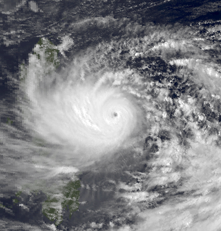
Typhoon Cimaron, known in the Philippines as Super Typhoon Paeng, was the most intense tropical cyclone to strike the Philippine island of Luzon since Typhoon Zeb in 1998. Originating from a tropical depression on October 25, Cimaron developed within an environment strongly favoring tropical cyclogenesis east of the Philippines. On October 28, the system underwent rapid intensification, culminating in attaining its peak strength with winds of 185 km/h (115 mph). Estimates from the Joint Typhoon Warning Center ranked the system as a Category 5-equivalent super typhoon with one-minute sustained winds of 260 km/h (160 mph), though this is argued to have underrepresented the typhoon's strength. The system moved ashore near Casiguran, Aurora in northern Luzon at peak strength. Crossing the island, Cimaron emerged over the South China Sea where conditions allowed for temporary reorganization. After becoming nearly stationary on November 1, the typhoon executed a tight anti-cyclonic loop and rapidly weakened. The storm degenerated into a tropical depression on November 4, before dissipating three days later off the coast of Vietnam.

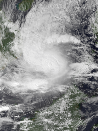
Severe Tropical Storm Tess known in the Philippines as Tropical Storm Welpring was the second of three tropical cyclones to directly impact the Philippines in a two-week time frame in 1988. An area of disturbed weather near the Philippines was first observed on November 1. Following an increase in organization, the disturbance was designated as a tropical cyclone on November 4. Moving west, Tess steadily strengthened due to favorable conditions aloft. During the evening of November 5, Tess was estimated to have achieved its highest intensity, with winds of 115 km/h (70 mph). Rapid weakening then ensured as Tess neared Vietnam, and after making landfall in the country on November 6, Tess dissipated the next day.

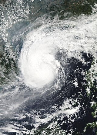
Typhoon Cary, known as Typhoon Ising in the Philippines, was the second of two tropical cyclones to affect Vietnam in a week. An area of disturbed weather developed southwest of Pohnpei on August 6, 1987. The system initially remained disorganized, but by August 14, Cary had attained tropical storm intensity. After initially moving north-northwest, Cary turned west-northwest, although intensification was slow to occur. On August 15, Cary was upgraded into a typhoon, and on August 17, the typhoon peaked in intensity. Typhoon Cary then made landfall in northern Luzon while at peak intensity. Across the Philippines, 954 houses were damaged and an additional 89 were destroyed, which left 55,567 people, or 13,247 families that were either homeless or otherwise sought shelter. Five people died in the country while damage totaled $5.58 million (1987 USD), including $1.45 million from agriculture and $4.13 million from infrastructure. The storm weakened over land, but re-intensified into a typhoon over the South China Sea. On August 21, Typhoon Cary passed just south of Hainan, where hundreds of homes were damaged but no fatalities occurred, and subsequently entered the Gulf of Tonkin. The storm weakened as it approached Vietnam, and on August 23, the storm dissipated inland over Laos. Across Vietnam, almost 40,000 ha of land were flooded or destroyed. Twenty people were killed and many others were injured.
Typhoon Faith, known in the Philippines as Typhoon Norming, struck both the Philippines and Vietnam during December 1998. A tropical disturbance developed within the vicinity of the western Caroline Islands during early December. At midday on December 8, the system developed into a tropical depression. Tracking northwest at a brisk pace, the depression gradually intensified, and was upgraded into a tropical storm at noon on December 9. Quickly intensifying, Faith turned to the west-northwest, and after tracking near Samar Island on the evening of December 10, Faith attained typhoon intensity. After clipping the northern tip of Palawan Island, the typhoon entered the South China Sea at peak intensity. Across the Philippines, 33 people were killed, with 30 others wounded and 36 others listed missing. A total of 6,423 homes were damaged and 3,234 houses were destroyed, leaving more than 20,000 homeless. Damage was estimated at $25.9 million, with $6.82 million from crops, $15.9 million from public infrastructure, and $3.37 million from private infrastructure.

Typhoon Eli, known in the Philippines as Typhoon Konsing, struck the Philippines and Hainan during mid-July 1992. A weak low pressure system developed in the Philippine Sea on July 7, which became a tropical depression on the next day. The depression tracked west-northwest and strengthened into a tropical storm on July 10. After turning more westward, Eli steadily intensified, and obtained typhoon intensity that evening. The storm attained its highest intensity of 130 km/h (80 mph) early on July 11 before striking northern Luzon. After entering the South China Sea, the storm maintained most of its intensity as it approached Hainan, although agencies disagree on how precisely strong it was. After passing through Hainan late on July 13, Eli passed through the Gulf of Tonkin on the next day before striking Vietnam, where Eli quickly dissipated.

Typhoon Zeke, known in the Philippines as Typhoon Etang, was the first of two typhoons to make landfall in China within a week during mid-July 1991. An area of disturbed weather developed east of the Philippines towards the end of the first week of July. Tracking west-northwestward, the disturbance organized into a tropical depression on July 9. After tracking across the Philippines, where it left two people missing and injured three others, the depression intensified into a tropical storm on July 10. The storm steadily deepened as it moved across the South China Sea, and on July 12 it strengthened into a typhoon. While at its peak intensity of 120 km/h (75 mph), Zeke moved onshore at Hainan, where it began to weaken. The system tracked across Vietnam on July 13, and dissipated within two days after moving inland.


