
The 2005 Pacific typhoon season was the least active typhoon season since 2000, producing 23 named storms, of which 13 became typhoons. It was an event in the annual cycle of tropical cyclone formation, in which tropical cyclones form in the western Pacific Ocean. The season ran throughout 2005, though most tropical cyclones typically develop between May and October. The season's first named storm, Kulap, developed on January 13, while the season's last named storm, Bolaven, dissipated on November 20. The season's first typhoon, Haitang, reached typhoon status on July 13, and became the first super typhoon of the year three days later.

The 2006 Pacific typhoon season was a destructive and deadly season, although it was near-average in terms of activity with a total of 23 named storms, 15 typhoons, and six super typhoons. Compared to the previous season, more typhoons inflicted damage across several countries, particularly China and the Philippines, some of which made landfall at higher intensities. The ratio of intense typhoons to all typhoons is at 0.73, the highest since 1970.

The 2003 Pacific typhoon season was a slightly below average yearlong period of tropical cyclogenesis exhibiting the development of 45 tropical depressions, of which 21 became named storms; of those, 14 became typhoons. Though every month with the exception of February and March featured tropical activity, most storms developed from May through October. During the season, tropical cyclones affected the Philippines, Japan, China, the Korean Peninsula, Indochina, and various islands in the western Pacific.

The 1994 Pacific typhoon season was an extremely active season in the annual cycle of tropical cyclone formation in the Western North Pacific, being the second most active season in the basin, only behind 1964. With a total of 36 tropical storms, where 20 of them reached typhoon strength and 6 further strengthening into super typhoons, during the course of the season, much like the Pacific hurricane season. The season had no official bounds and it ran year-round in 1994, but most tropical cyclones tend to form in the northwestern Pacific Ocean between May and November. Tropical storms that formed west of the date line were assigned a name by the Joint Typhoon Warning Center. The World Meteorological Organization-designated Regional Specialized Meteorological Centre for tropical cyclones for the region is the Japan Meteorological Agency. Tropical depressions that entered or formed in the Philippine area of responsibility were assigned a name by the Philippine Atmospheric, Geophysical and Astronomical Services Administration or PAGASA. This can result in some storms having two names.

The 1992 Pacific typhoon season was the fourth consecutive above-average season, producing 31 tropical storms, 16 typhoons and five super typhoons. It had no official bounds; it ran year-round in 1992. Despite this, most tropical cyclones tend to form in the northwestern Pacific Ocean between May and November. These dates conventionally delimit the period of each year when most tropical cyclones form in the northwestern Pacific Ocean.

The 1988 Pacific typhoon season was a very active season in terms of named storms, though it only featured 11 typhoons and 1 super typhoon. It had no official bounds; it ran year-round in 1988, but most tropical cyclones formed between May and November. Tropical storms that formed in the entire west Pacific basin were assigned a name by the Joint Typhoon Warning Center. Tropical depressions that enter or form in the Philippine area of responsibility are assigned a name by the Philippine Atmospheric, Geophysical and Astronomical Services Administration or PAGASA. This can often result in the same storm having two names.
The 1980 Pacific typhoon season was a slightly-below average season when compared to the long-term average, though it featured several intense storms. It ran year-round in 1980, but most tropical cyclones formed between June and December. These dates conventionally delimit the period of each year when most tropical cyclones form in the northwestern Pacific Ocean. A total of 28 tropical depressions formed this year in the Western Pacific, of which 24 became tropical storms and were assigned a name by the Joint Typhoon Warning Center. Beginning in March, tropical cyclones formed in each subsequent month through December. Of the 24 named storms, 15 storms reached typhoon intensity, of which 2 reached super typhoon strength.
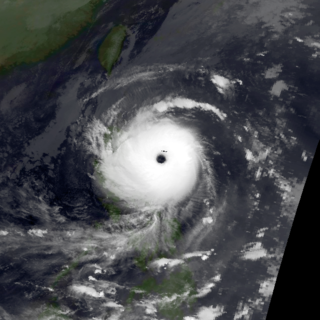
Typhoon Elsie, known in the Philippines as Typhoon Tasing, was one of the most intense known tropical cyclones to make landfall in the Philippines. A powerful Category 5 super typhoon, Elsie formed out of a tropical disturbance on October 13, 1989, and initially moved relatively slowly in an area of weak steering currents. On October 15, the storm underwent a period of rapid intensification, attaining an intensity that corresponds to a Category 3 hurricane on the Saffir–Simpson hurricane scale. After taking a due west track towards the northern Philippines, the storm intensified further, becoming a Category 5 super typhoon hours before making landfall in Luzon. After moving inland, the typhoon rapidly weakened to a tropical storm. Once back over water in the South China Sea, wind shear prevented re-intensifcation. Elsie eventually made landfall in Vietnam on October 22 and dissipated the following day over Laos.
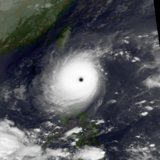
Typhoon Angela, known in the Philippines as Typhoon Rubing, was an intense tropical cyclone that formed in late September 1989. The storm developed from a tropical disturbance in the monsoon trough and moved generally westward throughout its duration. The storm ultimately peaked in intensity as a super typhoon and struck northern Luzon in the Philippines. After weakening and traversing the South China Sea, Angela bypassed Hainan to the south and struck Vietnam before dissipating. The storm caused severe damage and 119 fatalities in the Philippines. Thousands of houses were damaged, and hundreds of thousands of residents were impacted by the typhoon. Monetary damage is placed at $8 million.

Severe Tropical Storm Zita, known in the Philippines as Tropical Storm Luming, was a short-lived tropical cyclone that killed seven people throughout southern China in August 1997. Originating from a tropical disturbance over the South China Sea on August 19, Zita tracked westward as it quickly strengthened within a region of light wind shear, attaining winds of 140 km/h (85 mph) as it made landfall along the Leizhou Peninsula early on August 22. Maintaining this intensity, the storm made a second landfall in northern Vietnam later that day before rapidly weakening over land. The remnants of Zita were last noted over extreme northwestern Vietnam on August 24.

Typhoon Dot, known in the Philippines as Typhoon Kuring, was one of several tropical cyclones to impact southern China and northern Vietnam during the 1989 Pacific typhoon season. Originating from a tropical disturbance near Palau on June 4, Dot tracked west-northwestward towards the Philippines. Crossing the country on June 6, the system moved over the South China Sea and attained typhoon status. Late on June 8, Dot reached its peak intensity with winds estimated at 185 km/h (115 mph). The system weakened slightly the next day before making landfall in Hainan Island. A weakened storm then entered the Gulf of Tonkin before striking northern Vietnam and dissipating on June 12.

Tropical Storm Toraji was a short-lived and minimal tropical cyclone that brought inundating rainfall to areas of Southeast Asia in July 2007. The name Toraji was contributed to the western Pacific typhoon naming list by North Korea and stands for a broad bell flower. The third named storm of the annual typhoon season, Toraji developed from an area of disturbed weather within the South China Sea on July 4. As a result of its northwesterly track, the tropical depression moved over Hainan shortly after tropical cyclogenesis. Upon its emergence into the Gulf of Tonkin on July 5, Toraji quickly intensified into a tropical storm with winds of 65 km/h (40 mph); this would be the tropical cyclone's peak intensity for its entire duration. However, the JMA indicated that tropical storm intensity had been reached a day earlier. On the evening of July 5, Toraji made its final landfall on Dongxing, Guangxi before rapidly deteriorating inland and degenerating into a remnant low-pressure area by the following day.

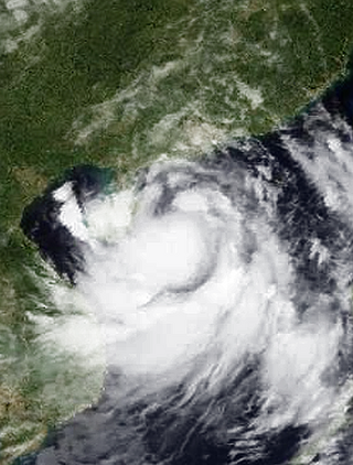
Typhoon Sally, known in the Philippines as Typhoon Maring, was an intense tropical cyclone that caused widespread damage across southeastern Asia, particularly in China, in September 1996. Forming well east of the Philippines on 5 September, Sally quickly intensified as it tracked westward within favorable conditions. The system reached tropical storm intensity several hours after tropical cyclogenesis was completed, and strengthened further into typhoon intensity the following day. On 7 September, Sally reached super typhoon status shortly before attaining its peak intensity with maximum sustained winds of 260 km/h (160 mph) and a barometric pressure of 940 mbar. Quickly moving across the South China Sea, Sally substantially weakened but remained a strong typhoon before making its first landfall on the Leizhou Peninsula on 9 September. The tropical cyclone's trek brought it briefly over the Gulf of Tonkin before making a final landfall near the border of China and Vietnam. The typhoon rapidly deteriorated inland and dissipated later that day.

Severe Tropical Storm Koni, known in the Philippines as Tropical Storm Gilas, caused moderate damage to areas of China and Vietnam in July 2003. The eighth tropical storm in the western Pacific that year, Koni originated from a disturbance situated within the monsoon trough well east of the Philippines on July 15. Tracking westward, intensification was slow and the system remained a tropical depression as it moved across the central Philippines on July 17. Upon moving into the South China Sea, however, conditions allowed for quicker strengthening, and as such the cyclone reached tropical storm status on July 18 before reaching its peak intensity with maximum sustained winds of 110 km/h (68 mph) and a minimum barometric pressure of 975 mbar, making it a severe tropical storm. However, atmospheric conditions began to deteriorate as Koni made landfall on Hainan on July 21, weakening the system. The tropical storm continued to weaken as it moved over the Gulf of Tonkin prior to a final landfall near Hanoi, Vietnam the following day. Tracking inland, the combination of land interaction and wind shear caused Koni to dissipate over Laos on July 23.

Typhoon Krovanh, known in the Philippines as Typhoon Niña, was a moderate tropical cyclone that caused a swath of damage stretching from the Philippines to Vietnam in August 2003. The fifteenth named storm and sixth typhoon in the western Pacific that year, Krovanh originated from a tropical disturbance within the monsoon trough on August 13. Despite rather favorable conditions, the initial tropical depression did not intensify significantly and degenerated into a remnant low on August 18. However, these remnants were able to reorganize and the system was reclassified as a tropical cyclone a day later. Intensification was rather rapid upon the storm's reformation – the depression reached tropical storm status on August 20 and then typhoon intensity two days later. Shortly after, Krovanh made landfall on Luzon at peak intensity with winds of 120 km/h (75 mph). The typhoon emerged into the South China Sea as a much weaker tropical storm, though it was able to restrengthen over warm waters. Once again at typhoon intensity, Krovanh clipped Haiyan before moving over the Leizhou Peninsula on its way to a final landfall near Cẩm Phả, Vietnam on August 25. Quick weakening due to land interaction occurred as Krovanh moved across northern Vietnam, where the storm met its demise the following day.

Typhoon Kalmaegi, known in the Philippines as Typhoon Luis, was the 22nd depression and the 15th named storm of the 2014 typhoon season. Kalmaegi was the first storm to make landfall over the Philippines since Typhoon Rammasun, two months prior. The storm caused flooding in Southeast Asia during mid-September. Kalmaegi started as a disturbance near Palau that could become a tropical cyclone in the next few days. JTWC would designate it to Tropical Depression 15W. PAGASA also named the system Luis as the 11th named storm inside PAR. Environmental conditions became more conducive for intensification, which allowed 15W to intensify into a tropical storm and attained the name Kalmaegi. On September 13, the storm intensified into a Category-1 typhoon as it moved through open warm waters. Around 17:00 PHT on September 14, the eye of Kalmaegi made landfall in the coastal town of Divilacan, Isabela, bringing gusty winds and heavy rains in the area.

Typhoon Cary, known as Typhoon Ising in the Philippines, was the second of two tropical cyclones to affect Vietnam in a week. An area of disturbed weather developed southwest of Pohnpei on August 6, 1987. The system initially remained disorganized, but by August 14, Cary had attained tropical storm intensity. After initially moving north-northwest, Cary turned west-northwest, although intensification was slow to occur. On August 15, Cary was upgraded into a typhoon, and on August 17, the typhoon peaked in intensity. Typhoon Cary then made landfall in northern Luzon while at peak intensity. Across the Philippines, 954 houses were damaged and an additional 89 were destroyed, which left 55,567 people, or 13,247 families that were either homeless or otherwise sought shelter. Five people died in the country while damage totaled $5.58 million (1987 USD), including $1.45 million from agriculture and $4.13 million from infrastructure. The storm weakened over land, but re-intensified into a typhoon over the South China Sea. On August 21, Typhoon Cary passed just south of Hainan, where hundreds of homes were damaged but no fatalities occurred, and subsequently entered the Gulf of Tonkin. The storm weakened as it approached Vietnam, and on August 23, the storm dissipated inland over Laos. Across Vietnam, almost 40,000 ha of land were flooded or destroyed. Twenty people were killed and many others were injured.

Typhoon Eli, known in the Philippines as Typhoon Konsing, struck the Philippines and Hainan during mid-July 1992. A weak low pressure system developed in the Philippine Sea on July 7, which became a tropical depression on the next day. The depression tracked west-northwest and strengthened into a tropical storm on July 10. After turning more westward, Eli steadily intensified, and obtained typhoon intensity that evening. The storm attained its highest intensity of 130 km/h (80 mph) early on July 11 before striking northern Luzon. After entering the South China Sea, the storm maintained most of its intensity as it approached Hainan, although agencies disagree on how precisely strong it was. After passing through Hainan late on July 13, Eli passed through the Gulf of Tonkin on the next day before striking Vietnam, where Eli quickly dissipated.
Severe Tropical Storm Durian was a deadly system that caused severe impacts in China and Vietnam. The seventh tropical depression and third named storm of the 2001 Pacific typhoon season, the storm was first noted on June 29 and quickly intensified into a tropical storm and given the name Durian by the Japan Meteorological Agency (JMA). Durian continued northwestward before intensifying into a severe tropical storm as it approached the Chinese coast. On July 1 just before landfall, Durian peaked in intensity, with the JMA estimating 10-min winds of 110 km/h (68 mph) and the Joint Typhoon Warning Center (JTWC) estimating 1-min winds of 140 km/h (87 mph). Durian made landfall on Zhanjiang at peak intensity, before quickly weakening over land and dissipating on July 3 over the mountains of Vietnam.

Severe Tropical Storm Ruth was a weak but destructive tropical storm which struck Vietnam during September 1980. Originating from a monsoon depression in the South China Sea, as it tracked westward, it intensified into a tropical depression on 12 September. Initially peaking with 10-minute sustained winds of 50 mph (85 km/h), after it made landfallin Hainan, China on 15 September, it weakened into a minimal tropical storm. Despite that, the warm waters of the Gulf of Tonkin allowed Ruth to re-intensify, peaking as a high-end tropical storm according to the Japan Meteorological Agency (JMA) and a minimal typhoon according to the Joint Typhoon Warning Center (JTWC). Soon after, it made its second landfall in Thanh Hóa province, Vietnam. Rapidly weakening once inland, it dissipated over Bilauktaung Range on 18 September.

