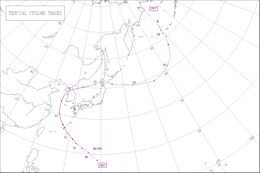
Typhoon Kompasu (2010)

Last updated

Map key
  Tropical depression (≤38 mph, ≤62 km/h)
  Tropical storm (39–73 mph, 63–118 km/h)
  Category 1 (74–95 mph, 119–153 km/h)
  Category 2 (96–110 mph, 154–177 km/h)
  Category 3 (111–129 mph, 178–208 km/h)
  Category 4 (130–156 mph, 209–251 km/h)
  Category 5 (≥157 mph, ≥252 km/h)
  Unknown
Storm type
Disc Plain black.svg Tropical cyclone
Solid black.svg Subtropical cyclone
ArrowUp.svg Extratropical cyclone, remnant low, tropical disturbance, or monsoon depression

The tropical disturbance that was to become Typhoon Kompasu was first analyzed by the Joint Typhoon Warning Center on August 25, as a tropical disturbance developing out of a surface trough of low pressure that was located near Chuuk State. [4] Over the next couple of days, the disturbance moved towards the northwest as it moved under the steering influence of a deep subtropical ridge of high pressure. During August 28, the disturbance developed a low level circulation which rapidly consolidated throughout that day. This led to the Japan Meteorological Agency and the JTWC designating it as Tropical Depression 08W during that day before the JTWC reported that the depression had intensified into a tropical storm. During the next day the PAGASA reported that the Tropical Depression had moved into their area of responsibility and subsequently named it Tropical Storm Glenda. Later that day the JMA also reported that Glenda had intensified into tropical storm and named it as Kompasu.[ citation needed ]

Lionrock (left), Namtheun (middle) and Kompasu (right) on August 31 LionrockKompasuNamtheun 31 August 2010.jpg
Lionrock (left), Namtheun (middle) and Kompasu (right) on August 31

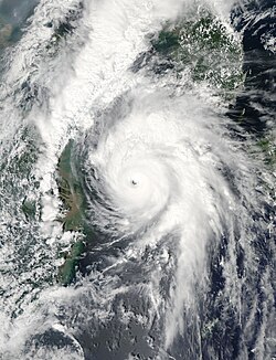
Early on August 30, the JTWC reported that Kompasu had developed an eye feature and had intensified into a typhoon. However the JMA did not follow suit until 1800 UTC, that day after the JTWC had assessed the intensity of Kompasu at 165 km/h (100 mph). During the next day as Kompasu passed over Okinawa both the JTWC and the JMA reported that Kompasu had peaked with windspeeds of 185 km/h, (115 mph) and 150 km/h, (90 mph) respectively.[ citation needed ]

The Japan Meteorological Agency's Regional Specialized Meteorological Center in Tokyo, Japan uses the Typhoon Committees Tropical Cyclone Intensity Scale which is based on 10-minute sustained winds for its tropical cyclone tracking information, while the Joint Typhoon Warning Center uses 1-minute sustained winds. [5] The conversion factor between the two is 1.14. [6] The JMA's peak intensity for Kompasu was 150 km/h, (90 mph) 10-minute sustained, or 170 km/h, (105 mph) 1-minute sustained. [6] The JTWC's peak intensity for Kompasu was 185 km/h, (115 mph) 1-minute sustained, or 165 km/h (100 mph) 10-minute sustained. [6] [7]

The storm made landfall near Seoul on September 2 at 6:35 AM local time. [1]

Preparations and impact

Okinawa

Okuma Recreation Facility staff members cleaning up debris left in the wake of Typhoon Kompasu Typhoon Kompasu 2010 Okinawa cleanup.JPG
Okuma Recreation Facility staff members cleaning up debris left in the wake of Typhoon Kompasu

On August 28, the United States Kadena Air Base in Okinawa began preparing for what was then Tropical Storm 08W. Tropical Cyclone Condition of Readiness (TCCOR) level three was issued the following morning. [8] By August 30, forecasts showed that a strengthening storm would strike the area, possibly bringing winds in excess of 130 km/h (81 mph). Following this, the TCCOR level was increased to two. [9] [10] For the first time in over three years, TCCOR level one was declared on August 31. Military personnel and residents across the island were urged to complete their preparations and remain indoors for the duration of the typhoon. [11] During the storm's passage on August 31, the highest warning level, TCCOR One-E (emergency) was declared. [12] Following Kompasu's passage, the emergency warning was changed to recovery as conditions improved. [13]

Throughout Okinawa, Kompasu brought strong winds and heavy rains, leaving an estimated 32,000 residences without power. [14] The highest rainfall total was measured in Motobu at 4.96 in (126 mm). [15] Winds in excess of 150 km/h (93 mph) felled a 300-year-old tree. The 17 m (56 ft) Sion Pine Tree was the last of its kind on the island and was once the symbol of the northern Okinawa Region. [16] The Okuma Recreation Facility sustained substantial damage and was closed to the public for at least a week. According to United States Air Force captain Adam Vaccarezza, concrete towers fell during the storm. Although Kompasu was a strong typhoon when it passed over Okinawa, no loss of life took place; however, five people were injured. [14] Some homes sustained roof damage across the region, prompting a few evacuations. Additionally, Kompasu resulted in the cancellation of 432 flights to and from the island chain, stranding 57,126 people. [15]

People's Republic of China

On August 31 at 12:40 CST, the Zhejiang Meteorological Observatory in Zhoushan City, Zhejiang issued an orange typhoon warning signal, and estimated that at midnight on the same day, the wind from the sea along the coast of Zhoushan would gradually intensify to 8–10 grade, and from the morning of September 1, will continue to increase from 10 to 12, and near the sea winds would exceed 12 grade. [17] Zhoushan City schools delayed the beginning of the school term, to ensure the safety of students and teachers. [18]

In Jiangsu Province, at 16:00 CST on August 31, the Jiangsu Province Meteorological Observatory issued a blue typhoon warning signal, and within the next 24 hours, Nantong, Yancheng, Lianyungang and other coastal areas received sea wind gusts of a 9–10 grade average. [19]

On the same day at 17:00 CST, the Shanghai Meteorological Observatory issued a blue typhoon warning signal for the Shanghai region, and expected that after midnight, winds would reach 6–8 grade, and that along the Yangtze River estuary, coastal winds would reach an intensity of 8–10 grade. [20] On September 1, the Shanghai Municipal Government announced that schools would be closed on that day, [21] whilst at Shanghai Honqiao and Pudong airports, flight times were adjusted for passengers' safety. [22]

In Shandong Province, on August 31, at 17:00 CST, the Shandong Province Meteorological observatory at Rizhao City issued a blue typhoon warning signal, and expected offshore wind intensities to reach 7–9 grade. [23]

South Korea

Tropical Storm Kompasu over South Korea on September 2 Kompasu sept 2 2010.jpg
Tropical Storm Kompasu over South Korea on September 2

Throughout South Korea, high winds and torrential rains cut power to an estimated 1.56 million residences. [24] According to the Korea Electric Power Corporation, the power outages cost 1.59 billion won (US$1.34 million). [25] Due to the relatively fast movement of the storm, much of the damage was sustained by intense winds which were recorded up to 188 km/h (117 mph), the sixth highest wind speed ever recorded in the country. The heaviest rains fell in Ganghwa, where 131.5 mm (5.18 in) was recorded. [26] In the capital city of Seoul, portions of the subway system were damaged, creating widespread travel issues. [24] Three lines of the subway system had interrupted service during the morning hours of September 3. [26] In Incheon, the Munhak Stadium sustained substantial damage as gale-force winds shredded the roof of the structure. [25] Damage to the stadium reached 10 billion won (US$8.3 million). [27] According to Korean officials, four people were killed by debris blown around by the storm. [25] A fifth, indirect fatality from electrocution was later linked to the storm in Mokpo. [28]

Roughly 10,000 hectares (25,000 acres) of agricultural land was inundated by the storm, resulting in widespread losses. At least 80,000 chickens were killed by the storm. [29] In South Chungcheong, 7,650 Anmyeon pine trees, regarded as the best type of tree for lumber in the region, were destroyed. Of these trees, 1,750 were more than 50 years old and averaged 24 m (79 ft) in height. [30]

According to the catastrophe modeler Eqecat, the storm was likely to cause $1–3 billion (USD) in damage throughout the country. [31] However, as of September 3, officials have estimated that damage has reached 68.52 billion won (US$58.3 million). [25] [27] [32] In the wake of the storm, the Korean disaster agency stated that 29,000 government officials, soldiers and volunteers were working on clearing debris and restoring power. [28] By the evening of September 2, electricity had been restored to 98% of the households affected. [30] Roughly $22 million (USD) was set aside as relief money for residents affected by the storm. The National Tax Service decided to allow extra time on deadlines for people to recover. [33]

North Korea

On September 1, North Korean media broadcast a typhoon warning, informing North Koreans to prepare for heavy rainfall. [2] According to the Korean Central News Agency, Thaetan, Suan, Sungho and Siwon Counties were affected from September 1–2, and within Pyongyang, Mangyongdae and Samsok districts received 80 mm and 65 mm of rain respectively. Areas within Kangwon, South Hamgyong and South Hwanghae provinces had winds of 10–18 metres per second. [34] Although the Government of North Korea withheld information regarding loss of life, a South Korean humanitarian group stated that dozens of people were killed across the country. Severe floods and landslides brought on by the storm destroyed nearly 9,000 structures and flooded 30,000 hectares of land. [35]

See also

Related Research Articles

<span class="mw-page-title-main">Typhoon Ewiniar (2006)</span> Pacific typhoon in 2006

Typhoon Ewiniar, known in the Philippines as Typhoon Ester, was the third named storm of the 2006 Pacific typhoon season and one that lasted for twelve days as a tropical cyclone, moving on a generally northward track. During its lifespan, it affected Palau, Yap, eastern China, the Ryūkyū Islands of Japan, South Korea as well as North Korea, briefly threatening to make landfall in North Korea before doing so in South Korea. Ewiniar is responsible for at least 181 deaths. However, an unofficial report stated that up to 10,000 people had been killed by flooding in North Korea, with 4,000 people missing.

<span class="mw-page-title-main">Typhoon Shanshan (2006)</span> Pacific typhoon in 2006

Typhoon Shanshan, known in the Philippines as Typhoon Luis, was a strong typhoon that affected parts of East Asia in late September 2006. The 13th named storm of the 2006 Pacific typhoon season, Typhoon Shanshan was also the seventh typhoon of the year operationally recognised by the Japan Meteorological Agency. In post-operational analysis Shanshan became the eighth typhoon of the year when Typhoon Maria was added to the list. The Joint Typhoon Warning Center considered Shanshan the 13th tropical storm and eighth typhoon of the season, a Category 4-equivalent typhoon in terms of 1-minute average wind speed. The name Shanshan was submitted to the naming list by Hong Kong and is a girls' given name.

<span class="mw-page-title-main">Typhoon Dianmu (2004)</span> Pacific typhoon in 2004

Typhoon Dianmu, known in the Philippines as Typhoon Helen, was a powerful typhoon that struck southeastern Japan during the 2004 Pacific typhoon season. The name Dianmu is the name of the goddess of thunder and lightning in Chinese folklore.

<span class="mw-page-title-main">Typhoon Sinlaku (2008)</span> Pacific typhoon in 2008

Typhoon Sinlaku, known in the Philippines as Typhoon Marce, was a typhoon which affected the Philippines, Taiwan, China and Japan. It was recognised as the 13th named storm and the ninth typhoon of the 2008 Pacific typhoon season by the Japan Meteorological Agency.

<span class="mw-page-title-main">2010 Pacific typhoon season</span> Typhoon season in the Western Pacific Ocean

The 2010 Pacific typhoon season, with 14 named storms is the least active Pacific typhoon season on record. Seven of them strengthened into typhoons while one reached super typhoon intensity. The Pacific typhoon season during 2010 was in fact less active than the 2010 Atlantic hurricane season, with only two other occurrences of that happening, 2005 and 2020. In the same year, the Pacific hurricane season broke the same record being the least active season on record. During the season, no storms made landfall in mainland Japan, only the second such occurrence since 1988. Also, all of the 14 named storms developed west of 150°E.

<span class="mw-page-title-main">Typhoon Conson (2004)</span> Pacific typhoon in 2004

Typhoon Conson, known in the Philippines as Typhoon Frank, was the first of the record ten typhoons to impact Japan during the 2004 Pacific typhoon season. Developing out of a tropical depression near the northern Philippines in early June, Conson slowly traveled towards the north. Gradually strengthening, the storm reached typhoon status late on June 7 according to the Joint Typhoon Warning Center and several hours later according to the Japan Meteorological Agency. After turning towards the northeast, the typhoon brushed Taiwan and reached its peak intensity with 10-minute sustained winds of 150 km/h (90 mph) on June 9. After reaching its peak, Conson gradually weakened, passing through Okinawa before being downgraded to a tropical storm the next day. On June 11, the storm made landfall as a minimal tropical storm in the Kōchi Prefecture just before becoming extratropical. The extratropical remnants continued towards the northeast and were last mentioned on June 14 crossing the International Date Line.

<span class="mw-page-title-main">2016 Pacific typhoon season</span> Typhoon season in the Western Pacific Ocean

The 2016 Pacific typhoon season is considered to have been the fourth-latest start for a Pacific typhoon season since reliable records began. It was an average season, with a total of 26 named storms, 13 typhoons, and six super typhoons. The season ran throughout 2016, though typically most tropical cyclones develop between May and October. The season's first named storm, Nepartak, developed on July 3, while the season's last named storm, Nock-ten, dissipated on December 28.

<span class="mw-page-title-main">2018 Pacific typhoon season</span> Typhoon season in the Western Pacific Ocean

The 2018 Pacific typhoon season was at the time, the costliest Pacific typhoon season on record, until the record was beaten by the following year. The season was well above-average, producing 29 storms, 13 typhoons, and 7 super typhoons. It was an event in the annual cycle of tropical cyclone formation, in which tropical cyclones form in the western Pacific Ocean. The season ran throughout 2018, though most tropical cyclones typically develop between May and October. The season's first named storm, Bolaven, developed on January 3, while the season's last named storm, Man-yi, dissipated on November 28. The season's first typhoon, Jelawat, reached typhoon status on March 29, and became the first super typhoon of the year on the next day.

<span class="mw-page-title-main">Typhoon Bolaven (2012)</span> Pacific typhoon in 2012

Typhoon Bolaven, known in the Philippines as Typhoon Julian, was regarded as the most powerful storm to strike the Korean Peninsula in nearly a decade, with wind gusts measured up to 186 km/h (116 mph). Forming as a tropical depression on August 19, 2012, to the southwest of the Mariana Islands, Bolaven steadily intensified as it slowly moved west-northwestward in a region favoring tropical development. The system was soon upgraded to a tropical storm less than a day after formation and further to a typhoon by August 21. Strengthening became more gradual thereafter as Bolaven grew in size. On August 24, the system attained its peak intensity, with winds of 185 km/h (115 mph) and a barometric pressure of 910 mbar. Weakening only slightly, the storm passed directly over Okinawa on August 26 as it began accelerating toward the north. Steady weakening continued as Bolaven approached the Korean Peninsula and it eventually made landfall in North Korea late on August 28 before transitioning into an extratropical cyclone. The remnants rapidly tracked northeastward over the Russian Far East before turning eastward and were last noted on September 1 crossing the International Dateline.

<span class="mw-page-title-main">Typhoon Sanba</span> Pacific typhoon in 2012

Typhoon Sanba, known in the Philippines as Typhoon Karen, was the strongest tropical cyclone worldwide in 2012. The sixteenth named storm and tenth typhoon of the annual typhoon season, Sanba formed as a tropical depression east of the Philippines on September 10. The storm gradually intensified as it moved generally northward in an area favorable for tropical development. The system was soon upgraded to a tropical storm less than a day after formation and subsequently further to a typhoon on September 12. Later that day, Sanba entered a phase of explosive intensification, quickly strengthening and gaining annular characteristics. On September 13, the system attained its peak intensity with maximum sustained winds of 125 mph (205 km/h), and a barometric pressure of 900 mbar, becoming the strongest typhoon in the Western Pacific Ocean since Megi in 2010. Accelerating towards more northerly latitudes, a period of gradual weakening ensued afterwards as its eye expanded. It made landfall on South Korea late on September 17 as a typhoon before transitioning into an extratropical cyclone the following day. Sanba's remnants tracked into the Primorsky Krai region of eastern Russia before they were last noted on September 19.

<span class="mw-page-title-main">Typhoon Abby (1983)</span> Pacific typhoon in 1983

Typhoon Abby, known in the Philippines as Typhoon Diding, was the second typhoon to strike Japan within a span of a few days in August 1983. First noted southeast of Guam on July 31, development of this system was initially slow to occur; it was first classified on August 5, and was upgraded into a tropical storm the next day. Intensification was rapid as Abby slowly recurved northward on August 7 and 8. After reaching peak intensity with winds of 140 mph (225 km/h) early on August 9, Abby slowly weakened, though the storm briefly re-intensified on August 11. By August 14, winds had diminished to 100 mph (160 km/h). Abby finally weakened back into a tropical storm on August 17 not long after making landfall in Japan. The following day, Abby completed the transition to an extratropical cyclone after moving through central Japan. However, meteorologists continued monitoring the storm for six more days.

<span class="mw-page-title-main">Typhoon Halola</span> Pacific typhoon in 2015

Typhoon Halola, known in the Philippines as Typhoon Goring, was a small but long-lived tropical cyclone in July 2015 that traveled 7,640 km (4,750 mi) across the Pacific Ocean. The fifth named storm of the 2015 Pacific hurricane season, Halola originated from a Western Pacific monsoon trough that had expanded into the Central Pacific by July 5. Over the next several days, the system waxed and waned due to changes in wind shear before organizing into a tropical depression on July 10 while well southwest of Hawaii. The depression strengthened into Tropical Storm Halola on the next day as it traveled westward. Halola crossed the International Date Line on July 13 and entered the Western Pacific, where it was immediately recognized as a severe tropical storm. The storm further strengthened into a typhoon over the next day before encountering strong wind shear on July 16, upon which it quickly weakened into a tropical depression as it passed south of Wake Island. However, the shear relaxed on July 19, allowing Halola to reintensify. On July 21, Halola regained typhoon status and later peaked with 10-minute sustained winds of 150 km/h (93 mph) and a minimum pressure of 955 hPa. From July 23 onward, increasing wind shear and dry air caused Halola to weaken slowly. The system fell below typhoon intensity on July 25 as it began to recurve northwards. Halola made landfall over Kyushu on July 26 as a tropical storm and dissipated in the Tsushima Strait shortly after.

<span class="mw-page-title-main">Typhoon Mindulle (2016)</span> Pacific typhoon in 2016

Typhoon Mindulle was a strong tropical cyclone which affected Japan in late August 2016. It was the ninth named storm and the second typhoon of the annual typhoon season in 2016.

<span class="mw-page-title-main">Typhoon Dinah (1987)</span> Pacific typhoon in 1987

Typhoon Dinah, known as Typhoon Luding in the Philippines, was the fourth typhoon to form during August 1987. An area of low pressure developed near Guam on August 19, and two days later, the low reached tropical storm intensity as it moved generally west. Intensification was initially gradual, with Dinah becoming a typhoon early on August 24, before it subsequently intensified at a faster pace. Dinah reached its highest strength on August 26 before turning northward on August 28 and into a less favorable conditions aloft, which prompted weakening. Dinah entered the Sea of Japan after passing near Okinawa on August 29, where Dinah leveled off in intensity. The system then began to recurve towards southwestern Japan, and after tracking through the area, Dinah transitioned into an extratropical cyclone on August 31, although the remnants could be traced for four more days as it approached the International Date Line.

<span class="mw-page-title-main">Typhoon Maria (2018)</span> Pacific typhoon in 2018

Typhoon Maria, known in the Philippines as Typhoon Gardo, was a powerful tropical cyclone that affected Guam, the Ryukyu Islands, Taiwan, and East China in early July 2018. Developing into the eighth named tropical storm of the 2018 Pacific typhoon season and passing the Mariana Islands on July 4, Maria strengthened into the fourth typhoon of the season and underwent rapid intensification the next day amid favorable environmental conditions. The typhoon reached its first peak intensity on July 6; subsequently, Maria weakened due to an eyewall replacement cycle, but it reintensified and reached a second, stronger peak intensity on July 9 with 10-minute sustained winds of 195 km/h (121 mph) and a minimum pressure of 915 hPa. Over the next three days, it started to gradually weaken due to another eyewall replacement cycle and decreasing sea surface temperatures. After crossing the Yaeyama Islands and passing north of Taiwan on July 10, Maria ultimately made landfall over Fujian, China, early on July 11, before dissipating the next day.

<span class="mw-page-title-main">Typhoon Jongdari</span> Pacific typhoon in 2018

Typhoon Jongdari was a strong, long-lived and erratic tropical cyclone that impacted Japan and East China in late July and early August 2018. Formed as the twelfth named storm of the 2018 typhoon season near Okinotorishima on July 24, Jongdari gradually intensified and developed into the fourth typhoon of the year on July 26. Influenced by an upper-level low and a subtropical ridge, Jongdari executed a rare counter-clockwise southeast of Japan on the next day. At that time, it also reached peak intensity. The typhoon made landfall in Kii Peninsula, over Mie Prefecture of Japan locally early on July 29.

<span class="mw-page-title-main">Typhoon Bavi</span> Pacific typhoon in 2020

Typhoon Bavi, known in the Philippines as Severe Tropical Storm Igme, was a powerful tropical cyclone that made landfall in North Korea in August 2020. The eighth named storm and third typhoon of the 2020 Pacific typhoon season, Bavi formed from a low pressure area depression on August 21 to the north of the Philippines and strengthened into a tropical storm on August 22. Bavi gradually strengthened as it skirted Taiwan and Okinawa, and became a typhoon on August 24. Passing over warm waters, Bavi turned to northwest and reached its peak intensity near Jeju Island on August 26. Thereafter, increasing wind shear and cooler waters caused Bavi to quickly weaken. Bavi made landfall in North Korea on August 27, and became an extratropical cyclone shortly thereafter.

<span class="mw-page-title-main">Typhoon Maysak (2020)</span> Pacific typhoon in 2020

Typhoon Maysak, known in the Philippines as Typhoon Julian, was a deadly, damaging and powerful tropical cyclone that struck the Ryukyu Islands and the Korean Peninsula in September 2020. The third typhoon of the 2020 Pacific typhoon season, Maysak formed from a tropical disturbance. The disturbance gradually organized, receiving the name Julian from PAGASA as it became a tropical depression. As the depression strengthened, the JMA subsequently named the system Maysak. Maysak rapidly intensified into a strong typhoon before weakening and making landfall in South Korea.

<span class="mw-page-title-main">Typhoon Haishen (2020)</span> Pacific typhoon in 2020

Typhoon Haishen, known in the Philippines as Super Typhoon Kristine, was a powerful tropical cyclone that became the first super typhoon of the 2020 Pacific typhoon season. Being also the tenth named storm and this season's fifth typhoon, Haishen's origins can be tracked back to a disorganised low pressure area situated near Guam. While the disturbance tracked south-westward and quickly organised, the JTWC issued a Tropical Cyclone Formation Alert (TCFA) on the system, and a day later, on September 1, the system became a tropical depression. The depression strengthened into Tropical Storm Haishen according to the Japan Meteorological Agency as it moved southwestward. At about 12:00 UTC on September 2, the Philippine Atmospheric, Geological and Astronomical Services Administration indicated that Haishen had entered the Philippine Area of Responsibility and was subsequently named Kristine. Later that day, Haishen became a typhoon. Intensification on September 3 was significant. Drifting northwestward into extremely favorable conditions, Haishen became a category 3-equivalent typhoon, acquiring a pinhole eye, before undergoing an eyewall replacement cycle (EWRC). Strengthening resumed soon after and the JTWC assessed wind speeds of 135 kn as it peaked as a powerful Category 4 super typhoon and had attained a new, symmetrical, clear eye.

<span class="mw-page-title-main">Tropical Storm Kompasu (2021)</span> Pacific tropical storm in 2021

Severe Tropical Storm Kompasu, known in the Philippines as Severe Tropical Storm Maring was a very large and deadly tropical cyclone that affected the Philippines, Taiwan, and southeast China. Part of the 2021 Pacific typhoon season, Kompasu originated from an area of low pressure east of the Philippines on 6 October 2021. The Japan Meteorological Agency (JMA) classified it as a tropical depression that day. A day later, the Philippine Atmospheric, Geophysical and Astronomical Services Administration (PAGASA) classified it as a tropical depression, naming it Maring. The cyclone was initially heavily disorganised, competing with another vortex, Tropical Depression Nando. Eventually, Maring became dominant, and the JMA reclassified it as a tropical storm, naming it Kompasu. Kompasu made landfall in Cagayan, Philippines, on 11 October 2021, and two days later, the storm made landfall in Hainan, China. The cyclone dissipated on 14 October 2021 while located over Vietnam.

References

  1. 1 2 (in Korean)
  2. 1 2 "Typhoon Kompasu hits South Korea capital Seoul". BBC. September 2, 2010. Retrieved September 3, 2010.
  3. "Typhoon Kompasu Hits Korea".
  4. Paul Stanko/Richard M, Devita (August 25, 2010). "Synoptic discussion for the Marianas". National Weather Service Forecast Office Guam. National Oceanic and Atmospheric Administration. Archived from the original on September 3, 2010. Retrieved September 3, 2010.
  5. Joint Typhoon Warning Center (March 31, 2008). "Frequently Asked Questions". United States Navy. Retrieved June 29, 2009.
  6. 1 2 3 "Section 2 Intensity Observation and Forecast Errors". United States Navy. 2009. Retrieved June 29, 2009.
  7. "JTWC Tropical Cyclone Running Best Track: Kompasu". Joint Typhoon Warning Center. December 17, 2002. Retrieved August 31, 2009.
  8. Dave Ornauer (August 28, 2010). "Tropical Storm 08W, # 1". Stars and Stripes. Retrieved September 3, 2010.
  9. Dave Ornauer (August 30, 2010). "Tropical Storm 08W, No. 3". Stars and Stripes. Retrieved September 3, 2010.
  10. Dave Ornauer (August 30, 2010). "Tropical Storm 08W (Kompasu), # 5". Stars and Stripes. Retrieved September 3, 2010.
  11. Dave Ornauer (August 29, 2010). "Typhoon 08W (Kompasu), # 8". Stars and Stripes. Retrieved September 3, 2010.
  12. Dave Ornauer (August 31, 2010). "Typhoon 08W (Kompasu), # 11: TCCOR 1-E declared". Stars and Stripes. Retrieved September 3, 2010.
  13. Dave Ornauer (August 31, 2010). "Typhoon 08W (Kompasu), # 13". Stars and Stripes. Retrieved September 3, 2010.
  14. 1 2 Tech. Sgt. Mike Tateishi (September 1, 2010). "Typhoon Kompasu crashes Okuma, spares Kadena". United States Pacific Air Forces. Archived from the original on September 5, 2010. Retrieved September 3, 2010.{{cite web}}: CS1 maint: unfit URL (link)
  15. 1 2 Chiyomi Sumida and David Allen (September 1, 2010). "Typhoon 08W (Kompasu) # 17, Okinawa aftermath". Stars and Stripes. Archived from the original on September 5, 2010. Retrieved September 3, 2010.{{cite web}}: CS1 maint: unfit URL (link)
  16. Staff Writer (September 3, 2010). "Centuries-old Sion Pine Tree felled by Typhoon Kompasu". Weekly Japan Update. Archived from the original on December 26, 2010. Retrieved September 3, 2010.{{cite web}}: CS1 maint: unfit URL (link)
  17. ""圆规"逼近浙江舟山发布台风橙色预警信号". Archived from the original on September 4, 2010. Retrieved September 4, 2010.
  18. 浙江部分中小学推迟开学 组织船回港人上岸
  19. 江苏省气象台发布台风蓝色预警
  20. 上海市气象台发布台风蓝色预警
  21. 上海中小学和幼托园所明日停课
  22. 受台风影响9月1日上海、杭州等地航班将调整
  23. 山东省日照市气象台发布台风蓝色预警
  24. 1 2 Staff Writer (September 2, 2010). "Typhoon Damage". 동아일보. Archived from the original on September 2, 2010. Retrieved September 2, 2010.
  25. 1 2 3 4 Kim Mi-ju (September 2, 2010). "Kompasu slams Korea, killing three". Joong Ang Daily. Archived from the original on September 3, 2010. Retrieved September 2, 2010.{{cite web}}: CS1 maint: unfit URL (link)
  26. 1 2 Staff Writer (September 2, 2010). "Powerful Typhoon Batters Central Korea". 동아일보. Archived from the original on September 2, 2010. Retrieved September 2, 2010.
  27. 1 2 Sangwon Yoon (September 2, 2010). "Typhoon suspends SKorean flights, trains, kills 4". The Associated Press. Archived from the original on September 5, 2010. Retrieved September 2, 2010.{{cite web}}: CS1 maint: unfit URL (link)
  28. 1 2 Staff Writer (September 3, 2010). "South Korea typhoon death toll grows to five". Agence-France Presse. Archived from the original on September 6, 2010. Retrieved September 3, 2010.{{cite web}}: CS1 maint: unfit URL (link)
  29. Staff Writer (September 3, 2010). 충남 민·관·군·경 '민수해복구 안간힘'...피해 규모 확산 깊은 시름 (in Korean). MSN. Archived from the original on September 3, 2010. Retrieved September 3, 2010.
  30. 1 2 Kim Mi-ju, Kim Bang-hyun (September 3, 2010). "Picking up the pieces after Kompasu hits region". Joong Ang Daily. Archived from the original on September 14, 2010. Retrieved September 3, 2010.{{cite web}}: CS1 maint: unfit URL (link)
  31. Chad Hemingway (September 2, 2010). "Typhoon Kompasu Could Cause Up To $3B In Losses In S. Korea". National Underwriter. Archived from the original on September 6, 2010. Retrieved September 2, 2010.{{cite web}}: CS1 maint: unfit URL (link)
  32. Staff Writer (September 3, 2010). 태풍 피해 1차 조사, 서산 149억, 당진 97억, 태안 323억3천만 원 (in Korean). MSN. Archived from the original on September 3, 2010. Retrieved September 3, 2010.
  33. Staff Writer (September 3, 2010). "Aftermath of Typhoon Kompasu". Arirang. Archived from the original on June 29, 2018. Retrieved September 3, 2010.
  34. September 2, 2010, DPRK Affected by Typhoon, Korean Central News Agency
  35. Staff Writer (September 15, 2010). "Dozens killed in North Korea typhoon". BBC News. Retrieved September 21, 2010.
Typhoon Kompasu (Glenda)
Typhoon Kompasu 2010-09-01 0450Z.jpg
Typhoon Kompasu approaching the Korean Peninsula on September 1