
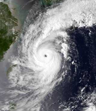
Typhoon Kujira, known in the Philippines as Typhoon Amang, was a long-lived tropical cyclone that lasted for 16 days and affected the island nations of Micronesia, Taiwan, and Japan in April 2003, as well as the earliest typhoon in a calendar year to ever make landfall on the latter. Forming from a broad area of disturbed weather as a tropical depression on April 9 well removed from any landmasses, Kujira quickly intensified in its early stages, and was upgraded to a tropical storm just two days after cyclogenesis. Strengthening slowed afterwards, though the storm attained typhoon intensity on April 14. Intensification continued and late on April 15, Kujira reached its peak intensity with winds of 165 km/h (103 mph) and a minimum barometric pressure of 930 mbar. Following peak intensity, Kujira began to track northwest and oscillate in strength, cresting an additional two times in intensity. On April 21, the typhoon was downgraded to tropical storm intensity and began to track erratically for several days east of Taiwan. However, on April 24, Kujira resumed a northward track and begin to weaken, and on April 24 was downgraded to tropical depression strength as it made landfall on Kyushu. Following landfall Kujira transitioned into an extratropical cyclone and continued to persist before these extratropical remnants crossed the International Dateline towards the end of April 2003.

Typhoon Caitlin, known in the Philippines as Typhoon Ising, contributed to major drought relief in Okinawa. A tropical disturbance formed in the middle of July 1991 in the eastern portion of the Western Pacific monsoon trough, and while tracking to the west-northwest, was designated a tropical depression on July 21. Thunderstorm activity associated with the depression increased markedly on July 22, and two days later, the depression was upgraded into Tropical Storm Caitlin. The storm turned northward as it rounded a subtropical ridge while gradually intensifying. Caitlin became a typhoon on July 25 and peaked in intensity on July 27 near Okinawa. The typhoon began to weaken as it turned northeast over the Korea Strait. On July 30, Catlin transitioned into an extratropical cyclone as it entered the Sea of Japan.

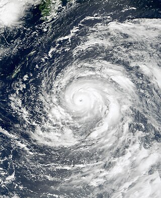
Typhoon Chaba was the strongest tropical cyclone in the western Pacific during 2004 and caused a swath of damage from the Mariana Islands to Japan from August through September of that year. Chaba was the Japan's second costliest storm during the season, only behind Songda in September, and peaked as a typhoon with maximum sustained winds equivalent to that of a Category 5 on the Saffir–Simpson hurricane wind scale.

Severe Tropical Storm Linfa, known in the Philippines as Tropical Storm Chedeng, brought deadly flooding to areas of the Philippines and Japan in May and June 2003. The fourth named storm within the northwestern Pacific that year, Linfa developed as a tropical depression just off the western coast of Luzon on May 25. The disturbance quickly intensified to reach tropical storm intensity a few hours after cyclogenesis. However, intensification leveled off as Linfa executed a small clockwise loop before a subsequent landfall on Luzon on May 27. Due to land interaction the storm temporarily weakened and decoupled before reforming in the Philippine Sea. Afterwards Linfa began reintensifying and reached its peak intensity on May 29 with maximum sustained winds of 100 km/h (65 mph) and a barometric pressure of 980 mbar. Following its peak the tropical storm began to deteriorate and transitioned into an extratropical cyclone on May 30; these extratropical remnants continued to track northward through Japan before dissipating in the Sea of Okhotsk on June 4.

Severe Tropical Storm Luke, known in the Philippines as Tropical Storm Pepang, was a short-lived tropical storm that brushed Japan during September 1991. Tropical Storm Luke formed from a disturbance that moved through the Northern Marianas and became a tropical depression on September 14 just to the west of the islands. The depression began to slowly intensify as it moved towards the west-northwest and Tropical Storm Luke was named on September 15. Luke reached peak intensity prior to recurving to the northeast and weakening due to increased shear. Tropical Storm Luke then paralleled the southeastern Japan coastline before transitioning into an extratropical cyclone. Overall, 12 people were killed and 23 others were injured. A total of 225 houses were destroyed while 52,662 others were flooded. There were reports of 644 landslides and roads were damaged at 418 locations. Rivers crested at 18 spots and six bridges were washed away. Greater than 40 domestic flights were cancelled. A total of 103 bullet trains were cancelled and 160 others delayed between Tokyo and Osaka, which left 315,000 people stranded. Additionally, 11,999 trains were halted in eastern and northern Japan, stranding 750,000 passengers. Two ships as well as 4,973 ha of farmland were damaged. Monetary damage totaled ¥24.2 billion yen (US$179 million).
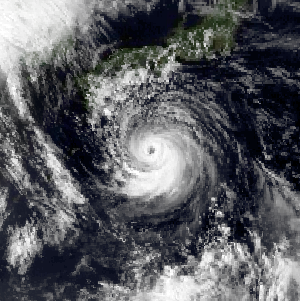
Typhoon Yancy, known in the Philippines as Typhoon Tasing, was one of the costliest and most intense tropical cyclones to strike Japan on record. Yancy was the sixth typhoon of the annual typhoon season and sixth tropical cyclone overall to impact Japan that year. Developing out of an area of disturbed weather in the open northwest Pacific on August 29, 1993, the precursor to Yancy tracked westward and quickly intensified to reach tropical storm strength on August 30. Just two days later, the tropical storm reached typhoon intensity as it recurved towards the northeast. A period of rapid intensification followed, allowing Yancy to quickly reach super typhoon intensity. The strong tropical cyclone reached peak intensity on September 2 with maximum sustained winds of 175 km/h (109 mph). The following day Yancy made its first landfall on Iōjima at nearly the same strength; over the course of the day the typhoon would make three subsequent landfalls on Japanese islands. Land interaction forced the tropical cyclone to weaken, and after its final landfall on Hiroshima Prefecture, Yancy weakened below typhoon intensity. After emerging into the Sea of Japan, Yancy transitioned into an extratropical cyclone; these remnants persisted as they meandered in the sea before dissipating completely on September 7.
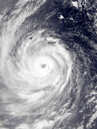
Typhoon Saomai, known in the Philippines as Typhoon Osang, was a long-tracked and intense tropical cyclone that brought flooding rainfall in Japan and the Korean Peninsula in September 2000. The torrential precipitation in Japan was considered some of the worst in the past century.

Typhoon Khanun, known in the Philippines as Typhoon Kiko, was the strongest tropical cyclone to make landfall on Zhejiang Province since Wanda in 1956. Khanun developed from an area of convection east-southeast of Yap on September 5, thereafter tracking northwestward. The precursor reached tropical storm status on September 7 and typhoon intensity the next day. The tropical cyclone reached its peak intensity on September 10 with winds estimated at 155 km/h (100 mph) and a minimum barometric pressure of 945 mbar. After weakening slightly, Khanun moved ashore Zhejiang Province the next day, weakening further as it tracked over land. After recurving into the Yellow Sea on September 12, Khanun became extratropical; these remnants continued to track into the open North Pacific before they were last noted on September 16.
Typhoon Orchid, known in the Philippines as Typhoon Sendang, was a long-lived typhoon that brushed Japan during October 1991. An area of disturbed weather formed near the Caroline Islands in early October. A mid-latitude cyclone weakened a subtropical ridge to its north, allowing the disturbance to slowly gain latitude, and on October 3, the system organized into a tropical depression. On the next day, the depression intensified into Tropical Storm Orchid. Continuing to intensify, the cyclone strengthened into a typhoon on the morning of October 6. Typhoon Orchid tracked due westward south of subtropical ridge while rapidly intensifying, and on October 7, Orchid reached its peak intensity. Shortly after its peak, the typhoon began to recurve north as the ridge receded. After interacting with Typhoon Pat, Orchid weakened below typhoon intensity on October 12. After accelerating to the northwest while gradually weakening, Orchid transitioned into an extratropical cyclone on October 14.

Tropical Storm Winona struck Japan during August 1990. An area of disturbed weather developed within the monsoon trough, located over the East China Sea, on August 4. Despite the presence of strong wind shear, a tropical depression developed later that day. The depression initially tracked northeast, bypassing the southern tip of Kyushu. Thereafter, the depression turned southeast, and on August 6, was believed to have obtained tropical storm intensity. In response to a building subtropical ridge to its southeast, Winona veered north while gradually intensifying. On August 9, Winona peaked in intensity, and while near peak intensity, made landfall in Shizuoka Prefecture early the following morning. Winona transitioned into an extratropical cyclone on August 11, and was last observed on August 14.
Typhoon Zola struck Japan during August 1990. An area of disturbed weather developed during mid-August to the west of Guam. The disturbance developed into a tropical depression on August 16 while tracking eastward. Decreased wind shear aided in intensification, and it is estimated that the depression strengthened into a tropical storm on August 17. Continuing to intensify, Zola turned northwest in response to a subtropical ridge to its east before obtaining typhoon intensity on August 20. Typhoon Zola reached its peak intensity the next day. After weakening slightly, the storm moved ashore on Honshu. On August 23, the system transitioned into an extratropical cyclone over the Sea of Japan.

Typhoon Gene, known in the Philippines as Typhoon Oyang, struck Japan during late September 1990. An area of disturbed weather formed several hundred kilometers south-southeast of Okinawa on September 18. Gradual development occurred as it tracked generally westward, and on September 22, the disturbance developed into a tropical depression. The depression intensified into a tropical storm the next day. Continuing to steadily intensify, Gene turned northwest and became a severe tropical storm on September 25. In the evening, Gene was declared a typhoon, and on September 26, attained its maximum intensity. Gene leveled off in intensity while recurving towards Japan. After brushing Kyushu and Shikoku on September 29 and Honshu on September 20, Gene weakened back to a tropical storm. On September 30, Gene transitioned into an extratropical cyclone, which was last noted on October 1.

Typhoon Hattie, known in the Philippines as Typhoon Pasing, was the fifth tropical cyclone of a record-six to hit Japan during the 1990 Pacific typhoon season. Hattie originated from an area of disturbed weather that developed within the Western Pacific monsoon trough towards the end of September. Tracking westward, the disturbance initially was slow to develop, although on September 30, the system was classified as a tropical depression. Following an improvement of its convective structure and an increase in associated convection, the depression was upgraded into Tropical Storm Hattie on October 1. Following the development of an eye, Hattie attained typhoon intensity on October 2. The typhoon continued to slowly deepen as its forward speed slowed. Despite a decrease in cloud top temperatures around the eye, Hattie was estimated to have attained peak intensity on October 5. After recurving to the north and then northeast, Hattie began to slowly weaken due to increased wind shear. On October 7, Hattie lost typhoon intensity, and after tracking directly over Tokyo, transitioned into an extratropical cyclone on the next day.

Typhoon Page, known in the Philippines as Typhoon Tering, was the fourth tropical cyclone to strike Japan in three months and the sixth in 1990. An area of disturbed weather developed on November 5 near the International Date Line. For more than two weeks, the disturbance failed to develop appreciably while it tracked generally westward. The disturbance began to organize on November 17. Four days later, the disturbance was designated a tropical depression, and on November 22, the depression was classified as a tropical storm. After resuming a westward course, Page intensified into a typhoon on November 24. Page then entered a period of rapid deepening before plateauing in intensity early on November 26. Page turned northwest, north, and later northeast as it rounded a subtropical ridge. Because of the change in steering, Page began to encounter stronger wind shear, which resulted in a prolonged weakening trend. On November 30, Page, just offshore Honshu, weakened below typhoon intensity, and became an extratropical cyclone on the same day after making landfall in central Honshu.

Severe Tropical Storm Gladys in August 1991 was a large tropical cyclone that affected Japan and South Korea. An area of disturbed weather first formed within the Western Pacific monsoon trough on August 15. Slowly organizing, the disturbance developed into a tropical depression on August 15. Heading northwest, Gladys became a tropical storm the following day. Despite forecasts of significant strengthening, its large size only enabled slow intensification. After turning west, Gladys attained peak intensity on August 21 near Okinawa. After turning north and bypassing Kyushu, Gladys began to encounter significant wind shear, which caused weakening. Gladys veered west, interacting with land. Gladys weakened to a tropical depression on August 24, and dissipated the next day.

Severe Tropical Storm Irving, known in the Philippines as Tropical Depression Edeng, was an early-season tropical cyclone that struck southern Japan during August 1992. A distinct but weak low-pressure area developed within the Western Pacific monsoon trough. A tropical depression formed on July 31, and following an increase in both organization and thunderstorm activity, the depression attained tropical storm intensity on the morning of August 2. After tracking west-northwest and then north, Irving turned to the northeast, and attained peak intensity a day later. In response to a subtropical ridge to the north, the system began to track west-northwestward, and made landfall at maximum intensity over southwestern Shikoku at peak intensity. Irving turned sharply to the west and rapidly weakened, dissipating over the Korea Strait at noon on August 5.

Typhoon Janis, known in the Philippines as Typhoon Gloring, was an early-season typhoon that struck Japan during August 1992. An area of disturbed weather formed near Pohnpei in late-July 1992, and after an increase in thunderstorm activity, a tropical depression developed on August 3. After passing near Guam, Janis tracked generally westward, and on August 5, the storm was believed to have attained typhoon intensity. After intensifying at a brisk pace, Janis attained peak intensity on August 6 near Okinawa. Thereafter, the typhoon began to weaken and accelerate as it recurved towards Kyushu, where it made landfall on the next day. Land interaction took its toll on the typhoon as it tracked northeast, paralleling the western coast of Honshu. On August 9, Janis transitioned into an extratropical low over Hokkaido.

Tropical Storm Percy, known in the Philippines as Tropical Storm Miling, was an early-season tropical cyclone that passed through Japan during July 1993. An area of disturbed weather developed in the Philippine Sea on July 26. Gradual development ensued and on July 27, the disturbance was classified as a tropical depression. The following morning, the depression was upgraded into Tropical Storm Percy. Moving north-northwest, Percy slowly deepened and obtained its peak intensity of 115 km/h (70 mph) and a minimum barometric pressure of 975 mbar (28.79 inHg). Late on July 29, Percy passed over Kyushu and began to weaken. Percy was downgraded to a tropical depression on July 30 and dissipated completely two days later.

Typhoon Robyn, known in the Philippines as Typhoon Openg, was a mid-season tropical cyclone that brushed Japan during August 1993. Typhoon Robyn originated from a near equatorial monsoon trough in the eastern Caroline Islands in late July. Tracking west-northwest, a tropical depression developed on August 1, and became a tropical storm the next day. Following an increase in organization, Robyn obtained typhoon intensity on August 5. The typhoon briefly tracked west before veering to the northwest while intensifying. On August 7, Robyn attained its peak intensity of 160 km/h (99 mph), with a barometric pressure of 940 mbar (28 inHg). After passing through the Ryukyu Islands, Robyn skirted past western Kyushu on August 9 while steadily weakening. Midday on August 10, Robyn lost typhoon intensity over the Sea of Japan. The next day, the system was declared an extratropical cyclone.

Tropical Storm Ofelia, known in the Philippines as Tropical Storm Luming, was an early-season tropical cyclone that passed south Japan during July 1993. An area of disturbed weather developed from the Western Pacific monsoon trough in late July 1993. The disturbance organized into a tropical depression on July 24, and the next day developed into a tropical storm. Tracking west-northwestward, Ofelia slowly deepened and attained its peak intensity of 80 km/h (50 mph) and a minimum barometric pressure of 994 mbar (29.4 inHg) at noon on July 26. On the next day, the storm made landfall shortly before weakening to a tropical depression. On July 27, Ofelia transitioned into an extratropical cyclone.


