Tīrau

Last updated

Tīrau
The dog and sheep buildings, Tirau, Waikato, New Zealand, 3 April 2008.jpg
Tīrau's corrugated iron 'giant dog' and 'big sheep' buildings
Tirau
Coordinates: 37°59′S175°45′E / 37.983°S 175.750°E / -37.983; 175.750
CountryNew Zealand
Region Waikato Region
District South Waikato District
WardTirau Ward
CommunityTirau Community
Electorates
Government
  Territorial Authority South Waikato District Council
  Regional council Waikato Regional Council
Area
[1]
  Total1.69 km2 (0.65 sq mi)
Population
 (June 2023) [2]
  Total890
  Density530/km2 (1,400/sq mi)
Time zone UTC+12 (NZST)
  Summer (DST) UTC+13 (NZDT)
Postcode
3410
Area code 07

Tīrau is a small town in the Waikato region of the North Island of New Zealand, 50 kilometres southeast of Hamilton. The town has a population of 804 (2018 census). [3] In the Māori language, "Tīrau" means "place of many cabbage trees."

Contents

Tīrau is a major junction in the New Zealand state highway network. Just south of the township is the intersection of State Highway 1 and State Highway 5, where traffic from Auckland and Hamilton on State Highway 1 split to go either to Rotorua on SH 5, or continue along SH 1 to Taupō and beyond to Napier, Palmerston North and Wellington. State Highway 27 splits off State Highway 1 in the north of the town, providing a route north to the Coromandel Peninsula and an alternative route to Auckland, bypassing Hamilton.

Tīrau is primarily a farming town but in recent years has begun to exploit the income that comes from being at a major road junction.

The small community of Okoroire (with hot springs) is located just north of Tīrau. [4] Okoroire railway station was over 4 km (2.5 mi) to the west of the springs. [5]

History and culture

The Tirau pub The Tirau pub.jpg
The Tīrau pub

European settlement

In the 19th century, Tīrau, then known as Oxford, was originally planned as a township. [6] However plans were changed after the entrepreneurial Rose family bought up large areas of land in the region, with the intention of making large returns when it came of high demand. Oxford later became a rural service town.

Oxford Royal Hotel opened on 15 April 1881. [7] A store followed in June, [8] but by September 1881 Oxford still only had the hotel and store. [9] 94 lots in the township, [6] which it had been planned to sell in 1891, [10] were offered for sale in 1882. [11] In the 1886 census, Oxford had a population of 48 in the 1896 census, [12] 27 in 1891 [13] and 127 in 1911. [14]

Name

Oxford was a name given to the proposed township when it was sold by McLean & Co in 1881. [15] It may have been to identify it as a sister town to Cambridge. [16] Oxford changed its name to Tirau on 23 May 1896. [17] To avoid confusion with Oxford in Canterbury, Piako County Council had been asked for a new name. They chose Tirau, which is the name of the hill [18] to the south. [19] The name was spelled without a macron until 2019, when the New Zealand Geographic Board made Tīrau the official name. [20]

Tirau in 1958 Tirau in 1958.jpg
Tīrau in 1958

Railway station

Oxford railway station was at the site where the Kinleith Branch crossed Okoroire Rd [21] The Thames Valley & Rotorua Railway Co. opened it on Monday 8 March 1886. [22] The first train left Oxford at 7.50am and arrived in Auckland at 4.35pm, [23] 133 mi 60 ch (215.2 km) away. [24] Morrinsville is 30 mi 60 ch (49.5 km) away. Oxford was the terminus for a few months until 21 June 1886, when the line was extended south to Putāruru [25] and Lichfield. [26] On 3 days a week, from the start of the train service, a coach ran to Ohinemutu, at Rotorua. [27]

New Zealand Railways Department took over the line on 1 April 1886. [28] By August there was a coal shed (23ft x 15ft, 50 tons capacity), 2 cottages, 60 ft (18 m) by 30 ft (9.1 m) goods shed, turntable and a stationmaster's house. In 1895 the stationmaster was moved to Putāruru and Tirau was downgraded to a flag station. However, by 1896 Tīrau also had a 4th class station, platform, cart approach, loading bank, cattle yards, 4-stall engine shed, urinals and a passing loop for 26 wagons (extended for 70 wagons in 1964). In 1898 it was recommended that the engine shed be moved to Grahamstown, though a double shed was then built there. By 1911 there were also sheep yards. [28]

563 passengers bought tickets in 1894, [29] 330 in 1895 [30] and 308 in 1896, when the main import was coal and the main exports timber and sheep. [31] It was renamed Tirau on 8 March 1886.

In 1963 a new station in dark Huntly brick, with a storeroom, office, waiting room and platform for two railcars was built for about £4,800. [28] Closure to passengers was on 12 November 1968 and to goods, except private siding traffic, on 29 March 1981. [32] In 1989 the station was derelict, but still had a low level platform. [28]

The main remnant of the station, alongside Prospect Avenue, [33] is an NZHPT Category II listed (on 5 September 1985, List Number 4230) brick water tower. [34] Opening of the station was delayed a week as the water supply wasn't complete. Like other Thames Valley & Rotorua stations, water was fed to a 6,000 imp gal (27 m3) brick tank, supplied from the Oraka Stream, about 90 ch (1.8 km) to the south, by a Blake [35] hydraulic ram. [28] Similar towers remain at Lichfield and Ngātira. [36] Fonterra still moves freight by rail from its Tīrau factory, [37] which runs a very large anaerobic digester. [38]

 Former adjoining stations 
Okoroire
Line open, station closed
3.7 km (2.3 mi)
  Kinleith Branch   Taumangi
Line open, station closed
5.79 km (3.60 mi) [39]

Recent history

In 1991, local business man Henry Clothier took advantage of the town's relatively cheap real estate and high traffic volume by opening an Antique shop in the former Rose Bros. grocery store building. Many other businesses followed suit off the back of his success throughout the 1990s until today. Tīrau has built a reputation as a shopping destination for antiques, collectibles and other niche items.

In 2005/06 the South Waikato District Council is working, on behalf of the Tīrau Ward, in conjunction with the community, to develop a concept plan for Tīrau's future. [40] This project is taking the success of Tīrau's transformation over the past decade and linking it with the requirements of the Local Government Act 2002 [41] new emphasis on the four well-beings, social, economic, environmental and cultural.

Marae

The local Paparāmu Marae and Te Apunga meeting house are affiliated with the Ngāti Raukawa hapū of Ngāti Mōtai and Ngāti Te Apunga. [42] [43]

Demographics

Statistics New Zealand describes Tīrau as a rural settlement, which covers 1.69 km2 (0.65 sq mi) [1] and had an estimated population of 890 as of June 2023, [2] with a population density of 527 people per km2. The settlement is part of the larger Tīrau statistical area.

Historical population for the settlement
YearPop.±% p.a.
2006741    
2013702−0.77%
2018804+2.75%
Source: [3]

Tīrau had a population of 804 at the 2018 New Zealand census, an increase of 102 people (14.5%) since the 2013 census, and an increase of 63 people (8.5%) since the 2006 census. There were 333 households, comprising 399 males and 402 females, giving a sex ratio of 0.99 males per female, with 156 people (19.4%) aged under 15 years, 150 (18.7%) aged 15 to 29, 351 (43.7%) aged 30 to 64, and 153 (19.0%) aged 65 or older.

Ethnicities were 81.0% European/Pākehā, 27.6% Māori, 1.5% Pacific peoples, 3.0% Asian, and 1.1% other ethnicities. People may identify with more than one ethnicity.

Although some people chose not to answer the census's question about religious affiliation, 56.7% had no religion, 29.9% were Christian, 1.5% had Māori religious beliefs, 1.1% were Buddhist and 1.9% had other religions.

Of those at least 15 years old, 66 (10.2%) people had a bachelor's or higher degree, and 186 (28.7%) people had no formal qualifications. 81 people (12.5%) earned over $70,000 compared to 17.2% nationally. The employment status of those at least 15 was that 333 (51.4%) people were employed full-time, 87 (13.4%) were part-time, and 27 (4.2%) were unemployed. [3]

Tīrau statistical area

Tīrau statistical area covers 293.10 km2 (113.17 sq mi) [1] and had an estimated population of 2,630 as of June 2023, [44] with a population density of 9.0 people per km2.

Historical population for the statistical area
YearPop.±% p.a.
20062,196    
20132,106−0.60%
20182,334+2.08%
Source: [45]

Tirau had a population of 2,334 at the 2018 New Zealand census, an increase of 228 people (10.8%) since the 2013 census, and an increase of 138 people (6.3%) since the 2006 census. There were 870 households, comprising 1,173 males and 1,161 females, giving a sex ratio of 1.01 males per female. The median age was 36.7 years (compared with 37.4 years nationally), with 552 people (23.7%) aged under 15 years, 417 (17.9%) aged 15 to 29, 1,047 (44.9%) aged 30 to 64, and 321 (13.8%) aged 65 or older.

Ethnicities were 87.4% European/Pākehā, 19.8% Māori, 1.4% Pacific peoples, 2.8% Asian, and 1.0% other ethnicities. People may identify with more than one ethnicity.

The percentage of people born overseas was 13.9, compared with 27.1% nationally.

Although some people chose not to answer the census's question about religious affiliation, 56.7% had no religion, 33.2% were Christian, 0.9% had Māori religious beliefs, 0.1% were Muslim, 0.3% were Buddhist and 1.7% had other religions.

Of those at least 15 years old, 234 (13.1%) people had a bachelor's or higher degree, and 408 (22.9%) people had no formal qualifications. The median income was $36,800, compared with $31,800 nationally. 336 people (18.9%) earned over $70,000 compared to 17.2% nationally. The employment status of those at least 15 was that 1,005 (56.4%) people were employed full-time, 282 (15.8%) were part-time, and 48 (2.7%) were unemployed. [45]

Tourism

The Tirau 'good shepherd', outside the local church The Tirau 'good shepherd'.jpg
The Tīrau 'good shepherd', outside the local church

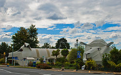
The town is now a well known tourist stop-off, and is characterised by many art works created out of corrugated iron. The church and many of the shops feature corrugated iron sculptures by local artist Steven Clothier and two large buildings are completely made from this material; the information centre which is shaped like a giant dog, [46] and the neighbouring sheep and ram building [47] - earning Tīrau the title of "Corrugated Capital of the World".

The Castle, a large toy museum on the town's southern limits which opened in 2000, can clearly be seen when heading towards the township from Rotorua or Taupō. The Tīrau dairy factory is New Zealand's only producer of lactalbumin, a key ingredient in the production of sports supplements. [48]

Government

Tīrau is governed locally by the South Waikato District Council. Nationally, Tīrau is part of the Taupō general electorate and the Te Tai Hauāuru Māori electorate. [49]

Transport

The Royal Hotel ran coaches twice a week from Cambridge from 1882. [50] By 1924 AARD was running a regular bus between Hamilton and Rotorua, via Tīrau. [51] In 2018 47% of those in the Tīrau statistical area said they drove to work, 30% worked from home, 4% walked and 0.5% cycled. [52] An Urban Connector bus runs twice a day between Tokoroa and Tīrau, via Putāruru and Lichfield. [53] Tīrau is also served by InterCity buses to Auckland, Gisborne, Hastings and Wellington. [54]

Education

Tirau Primary School is the sole school in Tīrau. It is a contributing primary school (Years 1–6) and has 123 students as of April 2023. [55] [56]

The nearest secondary school is Putaruru College, 8 kilometres (5 mi) south of Tīrau, in Putāruru.

See also

Related Research Articles

<span class="mw-page-title-main">Waikato</span> Region of New Zealand

Waikato is a region of the upper North Island of New Zealand. It covers the Waikato District, Waipa District, Matamata-Piako District, South Waikato District and Hamilton City, as well as Hauraki, Coromandel Peninsula, the northern King Country, much of the Taupō District, and parts of the Rotorua Lakes District. It is governed by the Waikato Regional Council.

<span class="mw-page-title-main">Matamata</span> Town in Waikato, New Zealand

Matamata is a town in Waikato, New Zealand. It is located near the base of the Kaimai Ranges, and is a thriving farming area known for Thoroughbred horse breeding and training pursuits. It is part of the Matamata-Piako District, which takes in the surrounding rural areas, as well as Morrinsville and Te Aroha. State Highway 27 and the Kinleith Branch railway run through the town. The town has a population of 9,130 as of June 2023.

<span class="mw-page-title-main">Ngāruawāhia</span> Town in Waikato, New Zealand

Ngāruawāhia is a town in the Waikato region of the North Island of New Zealand. It is located 20 kilometres (12 mi) north-west of Hamilton at the confluence of the Waikato and Waipā Rivers, adjacent to the Hakarimata Range. Ngāruawāhia is in the Hamilton Urban Area, the fourth largest urban area in New Zealand. The location was once considered as a potential capital of New Zealand.

<span class="mw-page-title-main">Te Awamutu</span> Town in Waikato, New Zealand

Te Awamutu is a town in the Waikato region in the North Island of New Zealand. It is the council seat of the Waipa District and serves as a service town for the farming communities which surround it. Te Awamutu is located some 30 kilometres (19 mi) south of Hamilton on State Highway 3, one of the two main routes south from Auckland and Hamilton.

<span class="mw-page-title-main">Putāruru</span> Town in Waikato, New Zealand

Putāruru is a small town in the South Waikato District and the Waikato region of New Zealand's North Island. It lies on the western side of the Mamaku Ranges and in the upper basin of the Waihou River. It is on the Oraka Stream 65 kilometres south-east of Hamilton. State Highway 1 and the Kinleith Branch railway run through the town.

Waharoa is a rural community in the Waikato region of New Zealand's North Island. It is located 7 km north of Matamata, and is part of the Matamata-Piako District. It is located at the junction of the Kinleith Branch railway and the East Coast Main Trunk Railway. State Highway 27 runs through the town, which is serviced by several shops and cafes and by a petrol station. Matamata Airport is just over 3 km (1.9 mi) north of Waharoa.

South Waikato District Council is the territorial authority for the South Waikato District of New Zealand.

<span class="mw-page-title-main">Rototuna</span> Suburb of Hamilton, New Zealand

Rototuna is a suburb in northern Hamilton, New Zealand, east of Flagstaff. It is one of the newest and fastest-growing suburbs in Hamilton, along with neighbouring Huntington and Flagstaff.

<span class="mw-page-title-main">Rotorua Branch</span> Mothballed railway line in New Zealand

The Rotorua Branch is a railway line from Putāruru to Rotorua, in the Waikato and Bay of Plenty regions of the North Island of New Zealand. Construction of the line was commenced by the Thames Valley and Rotorua Railway Company and finished by the Public Works Department (PWD). The complete line, 50.5 kilometres (31.4 mi) in length, opened in two sections; on 24 November 1893 to Tārukenga and the final 8 mi 43 ch (13.7 km) to Rotorua on 8 December 1894.

<span class="mw-page-title-main">Kinleith Branch</span>

The Kinleith Branch railway line is located in the Waikato region of New Zealand. The line was constructed by the Thames Valley and Rotorua Railway Company, Taupo Totara Timber Company and rebuilt by the Public Works Department primarily to serve the Kinleith Mill in 1952. It is 65 kilometres (40 mi) in length.

<span class="mw-page-title-main">Hinuera</span> Settlement in Waikato, New Zealand

Hinuera is a settlement in the Waikato Region of New Zealand's North Island. It is located along State Highway 29, approximately halfway between the cities of Hamilton and Tauranga. It also contains the Hinuera cliffs along State Highway 29.

<span class="mw-page-title-main">Whatawhata</span> Town in Waikato, New Zealand

Whatawhata, previously also spelt Whata Whata, is a small town in the Waikato region on the east bank of the Waipā River, at the junction of State Highways 23 and 39, 12 km (7.5 mi) from Hamilton. Te Araroa tramping route passes through Whatawhata.

Horotiu is a small township on the west bank of the Waikato River in the Waikato District of New Zealand. It is on the Waikato Plains 13 km (8.1 mi) north of Hamilton and 5 km (3.1 mi) south of Ngāruawāhia. From early in the 20th century it developed around a freezing works and other industries.

<span class="mw-page-title-main">Hamilton Central railway station, New Zealand</span> Defunct railway station in New Zealand

Hamilton Central was the name of a now-defunct railway station on the East Coast Main Trunk line which runs through the city of Hamilton in the Waikato region of New Zealand. The station was located in Hamilton's CBD and was made an underground station for the latter years of its existence before being closed. The underground platform still exists.

<span class="mw-page-title-main">Whitikahu</span> Locality in Waikato, New Zealand

Whitikahu is a settlement scattered along Whitikahu Rd in the Waikato District and Waikato region of New Zealand's North Island.

Okauia is a rural settlement and community located east of Matamata, in the Waikato region of New Zealand's North Island.

Lichfield is a rural settlement in the South Waikato District and Waikato region of New Zealand's North Island.

Kiwitahi is a rural community in the Matamata-Piako District and Waikato region of New Zealand's North Island, located directly south of Morrinsville.

<span class="mw-page-title-main">Kawaha Point</span> Suburb of Rotorua, New Zealand

Kawaha Point is a suburb of Rotorua in the Bay of Plenty Region of New Zealand's North Island.

<span class="mw-page-title-main">Te Rore</span> Locality in Waikato region, New Zealand

Te Rore was in the 1850s an important transhipment point on New Zealand's Waipā River, between the agriculture of the Waikato basin and its Auckland market. That was ended in 1864 by the Invasion of the Waikato, when Te Rore was, for a few months, part of the supply route to four redoubts set up nearby. It is now a rural community in the Waipa District, 6 km (3.7 mi) north of Pirongia and roughly the same distance south of Ngāhinapōuri on State Highway 39.

References

  1. 1 2 3 "ArcGIS Web Application". statsnz.maps.arcgis.com. Retrieved 5 November 2022.
  2. 1 2 "Subnational population estimates (RC, SA2), by age and sex, at 30 June 1996-2023 (2023 boundaries)". Statistics New Zealand . Retrieved 25 October 2023. (regional councils); "Subnational population estimates (TA, SA2), by age and sex, at 30 June 1996-2023 (2023 boundaries)". Statistics New Zealand . Retrieved 25 October 2023. (territorial authorities); "Subnational population estimates (urban rural), by age and sex, at 30 June 1996-2023 (2023 boundaries)". Statistics New Zealand . Retrieved 25 October 2023. (urban areas)
  3. 1 2 3 "Statistical area 1 dataset for 2018 Census". Statistics New Zealand. March 2020. 7013048–7013052.
  4. "1:50,000 map". topomap.co.nz. Topo Map. Retrieved 17 November 2018.
  5. "Current and historical topographic maps (topomaps) of New Zealand". www.mapspast.org.nz. 1944. Retrieved 13 May 2018.
  6. 1 2 "1881 Plan of the township of Oxford". www.aucklandcity.govt.nz. Retrieved 13 May 2018.
  7. "WAIKATO TIMES". paperspast.natlib.govt.nz. 21 April 1881. Retrieved 29 April 2021.
  8. "WAIKATO TIMES". paperspast.natlib.govt.nz. 23 June 1881. Retrieved 29 April 2021.
  9. "A TRIP TO OXFORD. WAIKATO TIMES". paperspast.natlib.govt.nz. 22 September 1881. Retrieved 29 April 2021.
  10. "TOWNSHIP OF OXFORD. Postponement of Sale. WAIKATO TIMES". paperspast.natlib.govt.nz. 23 April 1881. Retrieved 29 April 2021.
  11. "NEW ZEALAND HERALD". paperspast.natlib.govt.nz. 20 January 1882. Retrieved 29 April 2021.
  12. "RESULTS OF A CENSUS". StatsNZ. 28 March 1886.
  13. "RESULTS OF A CENSUS". StatsNZ. 5 April 1891.
  14. "Report on the results of a census". University of California. 1911.
  15. "AUCKLAND STAR". paperspast.natlib.govt.nz. 24 January 1881. Retrieved 29 April 2021.
  16. "Putaruru and Tīrau". teara.govt.nz. Retrieved 29 April 2021.
  17. "GAZETTE NOTICES. NEW ZEALAND HERALD". paperspast.natlib.govt.nz. 28 May 1895. Retrieved 28 April 2021.
  18. "THAMES ADVERTISER". paperspast.natlib.govt.nz. 19 April 1895. Retrieved 28 April 2021.
  19. "Tirau, Waikato". NZ Topo Map. Retrieved 28 April 2021.
  20. "NZGB notices – June 2019". Land Information New Zealand. 21 June 2019. Archived from the original on 1 July 2019. Retrieved 21 April 2020.
  21. "Current and historical topographic maps (topomaps) of New Zealand". www.mapspast.org.nz. 1944. Retrieved 14 May 2018.
  22. "The New Railway Time-Table". Waikato Times. 6 March 1886. p. 2. Retrieved 15 May 2018.
  23. "NEW ZEALAND HERALD". paperspast.natlib.govt.nz. 9 March 1886. Retrieved 26 April 2021.
  24. "Railway Extension". New Zealand Herald. 23 February 1886. p. 5. Retrieved 15 May 2018.
  25. "Appendix to the Journals of the House of Representatives — 1894 Session I — D-01 Page 45". atojs.natlib.govt.nz. Retrieved 14 May 2018.
  26. "Opening of Railway Line to Lichfield". New Zealand Herald. 15 June 1886. p. 4. Retrieved 15 May 2018.
  27. "NEW ZEALAND HERALD". paperspast.natlib.govt.nz. 11 March 1886. Retrieved 29 April 2021.
  28. 1 2 3 4 5 "Stations" (PDF). NZR Rolling Stock Lists. Retrieved 10 August 2020.
  29. "Appendix to the Journals of the House of Representatives — 1894 Session I — D-02 Page 17". atojs.natlib.govt.nz. Retrieved 14 May 2018.
  30. "Appendix to the Journals of the House of Representatives — 1895 Session I — D-02 Page 25". atojs.natlib.govt.nz. Retrieved 14 May 2018.
  31. "Appendix to the Journals of the House of Representatives — 1896 Session I — D-02 Page 11". atojs.natlib.govt.nz. Retrieved 14 May 2018.
  32. Scoble, Juliet (2010). "Names & Opening & Closing Dates of Railway Stations" (PDF). Rail Heritage Trust of New Zealand.
  33. "Prospect Ave". Google Maps. Retrieved 29 April 2021.
  34. "Water Tower". www.heritage.org.nz. Retrieved 29 April 2021.
  35. "John Blake - Graces Guide". www.gracesguide.co.uk. Retrieved 27 April 2021.
  36. "Operative District Plan" (PDF). South Waikato District Council. July 2015.
  37. "Fonterra and Toll Sign 20-year Rail Agreement". www.scoop.co.nz. November 2004. Retrieved 29 April 2021.
  38. "Biogas could help reduce New Zealand's emissions - study". Stuff. 21 December 2020. Retrieved 29 April 2021.
  39. Yonge, John Roger; Company, Quail Map (1993). New Zealand Railway and Tramway Atlas. Quail Map Company. ISBN   9780900609923.
  40. "South Waikato District Council". Archived from the original on 10 March 2007. Retrieved 2 April 2006.
  41. "Local Government Act 2002". Archived from the original on 24 March 2006. Retrieved 2 April 2006.
  42. "Te Kāhui Māngai directory". tkm.govt.nz. Te Puni Kōkiri.
  43. "Māori Maps". maorimaps.com. Te Potiki National Trust.
  44. "Population estimate tables - NZ.Stat". Statistics New Zealand . Retrieved 25 October 2023.
  45. 1 2 "Statistical area 1 dataset for 2018 Census". Statistics New Zealand. March 2020. Tīrau (185800). 2018 Census place summary: Tīrau
  46. "The i-SITE Visitor Centre" . Retrieved 26 April 2019.
  47. Wilkie, Kelsie (20 October 2016). "Corrugated iron sheep and ram buildings in Tirau for sale". Stuff.
  48. "Tirau". Fonterra. Retrieved 27 March 2013.
  49. "Find my electorate". Electoral Commission. Retrieved 19 December 2015.
  50. "WAIKATO TIMES". paperspast.natlib.govt.nz. 27 July 1882. Retrieved 29 April 2021.
  51. "WAIKATO TIMES". paperspast.natlib.govt.nz. 22 April 1924. Retrieved 29 April 2021.
  52. "2018 Census place summaries". www.stats.govt.nz. Retrieved 29 April 2021.
  53. "District Circuit". www.southwaikato.govt.nz. Retrieved 29 April 2021.
  54. "Book Bus Tickets Online | InterCity". www.intercity.co.nz. Retrieved 29 April 2021.
  55. "New Zealand Schools Directory". New Zealand Ministry of Education. Retrieved 12 December 2022.
  56. Education Counts: Tirau Primary School