Cachardistrict is an administrative district in the state of Assam in India. After independence, the pre-existing undivided Cachar district was split into four districts: Dima Hasao, Hailakandi, Karimganj, and the current Cachar district. Silchar is Cachar district's center of government.

Hailakandi district is one of the 33 districts of Assam state in north-eastern India. It makes up the Barak Valley alongside Cachar and Karimganj. It was constituted as a civil subdivision on 1 June 1869. Subsequently, it was upgraded to a district in 1989, when it was split from Cachar district.

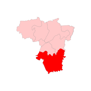
Karimganj district is one of the 31 districts of the Indian state of Assam. Karimganj town is both the administrative headquarters district and the biggest town of this district. It is located in southern Assam and borders Tripura and the Sylhet Division of Bangladesh. It makes up the Barak Valley alongside Hailakandi and Cachar. Karimganj was previously part of the Sylhet District before the Partition of India. It became a district in 1983.

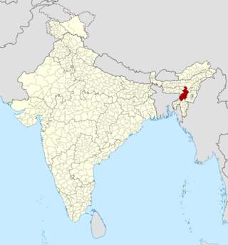
Dima Hasao district, is an administrative district in the state of Assam, India. As of 2011, it is the least populous district of Assam.

Silchar is a city and the headquarters of the Cachar district of the state of Assam, India. It is second largest city of Assam after Guwahati in terms of area, population and GDP. It is also administrative capital of Barak Valley division. It is located 343 kilometres south east of Guwahati. It was founded by Captain Thomas Fisher in 1832 when he shifted the headquarters of Cachar to Janiganj in Silchar. It earned the moniker "Island of Peace" from Indira Gandhi, the then Prime Minister of India. Silchar is the site of the world's first polo club and the first competitive polo match. In 1985, an Air India flight from Kolkata to Silchar became the world's first all-women crew flight. Silchar was a tea town and Cachar club was the meeting point for tea planters.

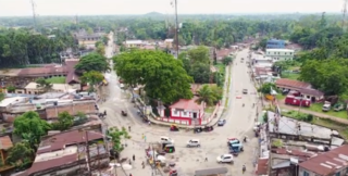
Karimganj is a town in the Karimganj District of the Indian state of Assam. It is the administrative headquarters of the district.

The Dimasa Kingdom was a late medieval/early modern kingdom in Assam, Northeast India ruled by Dimasa kings. The Dimasa kingdom and others that developed in the wake of the Kamarupa kingdom were examples of new states that emerged from indigenous communities in medieval Assam as a result of socio-political transformations in these communities. The British finally annexed the kingdom: the plains in 1832 and the hills in 1834. This kingdom gave its name to undivided Cachar district of colonial Assam. And after independence the undivided Cachar district was split into three districts in Assam: Dima Hasao district, Cachar district, Hailakandi district. The Ahom Buranjis called this kingdom Timisa.
Hojai is a town and a municipal board in Hojai district in the Indian state of Assam. It is located on the banks of the two tributaries of Brahmaputra, namely Kapili and Jamuna.
Lakhipur, is a town and a Municipal Board in Cachar district in the Indian state of Assam.
Silchar Part-X is a census town in Cachar district in the Indian state of Assam.

The Barak Valley is the southernmost region and administrative division of the Indian state of Assam. It is named after the Barak river. The Barak valley consists of three administrative districts of Assam namely - Cachar, Karimganj, and Hailakandi. The main and largest city is Silchar, which seats the headquarter of Cachar district and also serves as administrative divisional office of Barak valley division. The valley is bordered by Mizoram and Tripura to the south, Bangladesh and Meghalaya to the west and Manipur to the east respectively. Once North Cachar Hills was a part of Cachar district which became a subdivision in 1951 and eventually a separate district. On 1 July 1983, Karimganj district was curved out from the eponymous subdivision of Cachar district. In 1989 the subdivision of Hailakandi was upgraded into Hailakandi district.
The Barman Kacharis are an indigenous community of Northeast India and are a subsection of the Dimasa people in Barak Valley but claim to a separate group in Brahmaputra Valley. They are mainly found in the districts of Lower Assam and in Barak Valley like Cachar, Hailakandi and Karimganj and some parts of Arunachal Pradesh. Barman Kachari is Dimasa convert group of North-East India. Since the 2002 Amendment act, many Barman Kacharis in Assam are referred to as 'Barman'. They are sparsely found in Brahmaputra valley.
Assam – 16th largest, 15th most populous and 26th most literate state of the 28 states of the democratic Republic of India. Assam is at 14th position in life expectancy and 8th in female-to-male sex ratio. Assam is the 21st most media exposed states in India. The Economy of Assam is largely agriculture based with 69% of the population engaged in it. Growth rate of Assam's income has not kept pace with that of India's during the Post-British Era; differences increased rapidly since the 1970s. While the Indian economy grew at 6 percent per annum over the period of 1981 to 2000, the same of Assam's grew only by 3.3 percent.
Kalain is situated in a strategic location of the Cachar district of Assam, India. It is about 28.5 kilometres (17.7 mi) from the district headquarters, Silchar, and is called the Gateway to Barak Valley. There are three railway stations that connect Kalain smoothly to rest of the valley and the state of Assam; one at Hilara, one at Sukritipur. and one at Bihara
Dholai Assembly constituency is one of the 126 state legislative assembly constituencies in Assam state in North Eastern India. It is also one of the 7 state legislative assembly constituencies included in the Silchar Lok Sabha constituency. This constituency is reserved for the Scheduled caste candidates.
Sonai is a town in the Cachar district in the Indian state of Assam. It is also the name of a circle and block in the town. Government of Assam declared it as a municipal area on 2016 with 11 wards. The River Sonai flows through the town of Sonai joining with Barak River near Dungripar Village of Sonai. The Chandragiri Park and an Archeological site, a temple of Kachari Kingdom at Shivtilla (Changutilla) near Madhab Chandra Das College is a famous place to visit.
Barman Thar, where “thar” means language, is a highly endangered language. It is a Tibeto-Burman language that belongs to the Boro–Garo sub-group. The population of the Barman Kachari community is 24,237, according to a 2017 census. However, only a small part of this population speaks the language.

The Dimasa Kachari plains tribe of Cachar are known as Barman, forming one of the indigenous tribes of undivided Cachar. The Dimasas, inhabiting in the Cachar district are officially recognized as one of the Scheduled Tribes under the plains category in Assam in the name called “Barmans in Cachar”.

The Bengali Hindus are the second-largest ethno-religious group just after Assamese Hindus in Assam. As per as estimation research, around 6–7.5 million Bengali Hindus live in Assam as of 2011, majority of whom live in Barak Valley and a significant population also resides in mainland Brahmaputra Valley. The Bengali Hindus are today mostly concentrated in the Barak Valley region, where they were historically a minority, and now are politically, economically and socially dominant. Assam hosts the second-largest Bengali Hindu population in India after West Bengal.
The Barak state movement includes political activities organised by various individuals, organizations and political parties, for creation of a separate state of Barak, within the republic of India, with Silchar as the capital. The proposed state corresponds to the 4 southern districts of the state of Assam namely: Cachar, Hailakandi, Karimganj, Dima Hasao, Hojai's and Jiribam of Manipur respectively. The total area and population of proposed state is 13.379 km2 and 4.5 million as per 2011 Census. The area is covered by thick tropical forests and is surplus in natural resources like tea, oil, natural gas and jute. There are around 125 tea gardens across the Valley. The Minister of Petroleum and Natural Gas of India Mr. Hardeep Singh Puri on a visit have stated that the region is rich in natural gas and have further said that, "If those huge reserve is properly used, then it will definitely boost local industry & employment.


