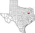
Union Hill, Henderson County, Texas

Last updated

Union Hill, Texas
USA Texas location map.svg
Red pog.svg
Union Hill
Usa edcp location map.svg
Red pog.svg
Union Hill
Coordinates: 32°18′29″N95°35′19″W / 32.30806°N 95.58861°W / 32.30806; -95.58861
Country United States
State Texas
County Henderson
Elevation
459 ft (140 m)
Time zone UTC-6 (Central (CST))
  Summer (DST) UTC-5 (CDT)
Area code(s) 430, 903
GNIS feature ID1889892 [1]

Union Hill is an unincorporated community in Henderson County, located in the U.S. state of Texas. [1]

Related Research Articles

<span class="mw-page-title-main">Texas</span> U.S. state

Texas is a state in the South Central region of the United States. At 268,596 square miles (695,660 km2), and with more than 30 million residents in 2023, it is the second-largest U.S. state by both area and population. Texas shares borders with the states of Louisiana to the east, Arkansas to the northeast, Oklahoma to the north, New Mexico to the west, and the Mexican states of Chihuahua, Coahuila, Nuevo León, and Tamaulipas to the south and southwest; and has a coastline with the Gulf of Mexico to the southeast.

<span class="mw-page-title-main">Washington County, Texas</span> County in Texas, United States

Washington County is a county in Texas. As of the 2020 census, the population was 35,805. Its county seat is Brenham, which is located along U.S. Highway 290, 72 miles northwest of Houston. The county was created in 1835 as a municipality of Mexico and organized as a county in 1837. It is named for George Washington, the first president of the United States.

<span class="mw-page-title-main">Kerr County, Texas</span> County in Texas, United States

Kerr County is a county located on the Edwards Plateau in the U.S. state of Texas. As of the 2020 census, its population was 52,598. Its county seat is Kerrville. The county was named by Joshua D. Brown for his fellow Kentucky native, James Kerr, a congressman of the Republic of Texas. The Kerrville, TX Micropolitan Statistical Area includes all of Kerr County.

<span class="mw-page-title-main">Houston County, Texas</span> County in Texas, United States

Houston County is a county located in the U.S. state of Texas. As of the 2020 census, its population was 22,066. Its county seat is Crockett. Houston County was one of 46 entirely dry counties in the state of Texas, until voters in a November 2007 special election legalized the sale of alcohol in the county.

<span class="mw-page-title-main">Bowie County, Texas</span> County in Texas, United States

Bowie County is a county in the U.S. state of Texas. Its legal county seat is Boston, though its courthouse is located in New Boston. As of the 2020 census, the population was 92,893. Bowie County is part of the Texarkana metropolitan statistical area. The county is named for James Bowie, the legendary knife fighter who died at the Battle of the Alamo.

<span class="mw-page-title-main">Angelina County, Texas</span> County in Texas, United States

Angelina County is a county located in the U.S. state of Texas. It is in East Texas and its county seat is Lufkin.

<span class="mw-page-title-main">Hillsboro, Texas</span> City in Texas, United States

Hillsboro is a city in and the county seat of Hill County, Texas, United States. The population was 8,221 at the 2020 census.

<span class="mw-page-title-main">Texas Hill Country</span> Region of Texas

The Texas Hill Country is a geographic region of Central and South Texas, forming the southeast part of the Edwards Plateau. Given its location, climate, terrain, and vegetation, the Hill Country can be considered the border between the American Southeast and Southwest. The region represents the very remote rural countryside of Central Texas, but also is home to growing suburban neighborhoods and affluent retirement communities.

<span class="mw-page-title-main">United States District Court for the Western District of Texas</span> United States federal district court in Texas

The United States District Court for the Western District of Texas is a federal district court. The court convenes in San Antonio with divisions in Austin, Del Rio, El Paso, Midland, Pecos, and Waco. It has jurisdiction in over 50 Trans-Pecos, Permian Basin, and Hill Country counties of the U.S. state of Texas. This district covers over 92,000 square miles (240,000 km2) and seven divisions.

<span class="mw-page-title-main">Nueces massacre</span>

The Nueces Massacre, also known as the Massacre on the Nueces, was a violent confrontation between Confederate soldiers and German Texans on August 10, 1862, in Kinney County, Texas U.S. Many first-generation immigrants from Germany settled in Central Texas in a region known as the Hill Country. They tended to support the United States and were opposed to the institution of slavery. Because of these sentiments, the Confederate States of America imposed martial law on Central Texas. A group of Germans, fleeing from the Hill Country to Mexico and onward to U.S.-controlled New Orleans, was confronted by a company of Confederate soldiers on the banks of the Nueces River. The ensuing German defeat represented an end to overt German resistance to Confederate governance in Texas, but it also fueled outrage among the German-Texan population. Disputes over the confrontation and the efficacy of Confederate actions after the battle, according to historian Stanley McGowen, continue to plague the Hill Country into the 21st century.

<span class="mw-page-title-main">Texas in the American Civil War</span>

Texas declared its secession from the Union on February 1, 1861, and joined the Confederate States on March 2, 1861, after it had replaced its governor, Sam Houston, who had refused to take an oath of allegiance to the Confederacy. As with those of other states, the Declaration of Secession was not recognized by the US government at Washington, DC. Some Texan military units fought in the Civil War east of the Mississippi River, but Texas was more useful for supplying soldiers and horses for the Confederate Army. Texas' supply role lasted until mid-1863, when Union gunboats started to control the Mississippi River, which prevented large transfers of men, horses, or cattle. Some cotton was sold in Mexico, but most of the crop became useless because of the Union's naval blockade of Galveston, Houston, and other ports.

<span class="mw-page-title-main">Secession in the United States</span> A state leaving the Union

In the context of the United States, secession primarily refers to the voluntary withdrawal of one or more states from the Union that constitutes the United States; but may loosely refer to leaving a state or territory to form a separate territory or new state, or to the severing of an area from a city or county within a state. Advocates for secession are called disunionists by their contemporaries in various historical documents.

<span class="mw-page-title-main">U.S. state</span> Constituent polity of the United States

In the United States, a state is a constituent political entity, of which there are 50. Bound together in a political union, each state holds governmental jurisdiction over a separate and defined geographic territory where it shares its sovereignty with the federal government. Due to this shared sovereignty, Americans are citizens both of the federal republic and of the state in which they reside. State citizenship and residency are flexible, and no government approval is required to move between states, except for persons restricted by certain types of court orders.

<span class="mw-page-title-main">1988 State of the Union Address</span> Speech by US president Ronald Reagan

The 1988 State of the Union Address was given by the 40th president of the United States, Ronald Reagan, on January 25, 1988, at 9:00 p.m. EST, in the chamber of the United States House of Representatives to the 100th United States Congress. It was Reagan's seventh and final State of the Union Address and his eighth and final speech to a joint session of the United States Congress. Presiding over this joint session was the House speaker, Jim Wright, accompanied by George H. W. Bush, the vice president.

Grapetown is an unincorporated farming and ranching community 9.5 miles (15.3 km) south of Fredericksburg, situated on South Grape Creek in Gillespie County, in the U.S. state of Texas. It is located on the old Pinta Trail. Grapetown is noted for being the site of the first annual Gillespie County Bundes Schützenfest. The school was designated a Recorded Texas Historic Landmark in 1984, Marker number 10048.

<span class="mw-page-title-main">1860 United States presidential election in Texas</span> Election in Texas

The 1860 United States presidential election in Texas was held on November 6, 1860. State voters chose four electors to represent the state in the Electoral College, which chose the president and vice president.

<span class="mw-page-title-main">Bristol, Texas</span> Census-designated place in Texas, United States

Bristol is a census-designated place in Ellis County, Texas, United States. The population was 668 at the 2010 census.

<span class="mw-page-title-main">Veronica Escobar</span> American politician (born 1969)

Veronica Escobar is an American politician serving as the U.S. representative for Texas's 16th congressional district, based in El Paso, since 2019. A member of the Democratic Party, she served as an El Paso County commissioner from 2007 to 2011 and the El Paso county judge from 2011 until 2017.

References

  1. 1 2 "Union Hill, Texas". Geographic Names Information System . United States Geological Survey, United States Department of the Interior.