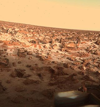
Utopia Planitia is a large plain within Utopia, the largest recognized impact basin on Mars and in the Solar System with an estimated diameter of 3,300 km (2,100 mi). It is the Martian region where the Viking 2 lander touched down and began exploring on September 3, 1976, and the Zhurong rover touched down on May 14, 2021, as a part of the Tianwen-1 mission. It is located at the antipode of Argyre Planitia, centered at 46.7°N 117.5°E. It is also in the Casius quadrangle, Amenthes quadrangle, and the Cebrenia quadrangle of Mars. The region is in the broader North Polar/Borealis Basin that covers most of the Northern Hemisphere of Mars.

Argyre Planitia is a plain located within the impact basin Argyre in the southern highlands of Mars. Its name comes from a map produced by Giovanni Schiaparelli in 1877; it refers to Argyre, a mythical island of silver in Greek mythology.

Chryse Planitia is a smooth circular plain in the northern equatorial region of Mars close to the Tharsis region to the west, centered at 28.4°N 319.7°E. Chryse Planitia lies partially in the Lunae Palus quadrangle, partially in the Oxia Palus quadrangle, partially in the Mare Acidalium quadrangle. It is 1600 km or 994 mi in diameter and with a floor 2.5 km below the average planetary surface altitude, and has been suggested to be an ancient buried impact basin, though this is contested. It has several features in common with lunar maria, such as wrinkle ridges. The density of impact craters in the 100 to 2,000 metres range is close to half the average for lunar maria.

Budh Planitia is a large plain on Mercury. It lies to the east of Odin Planitia. It falls within the Tolstoj quadrangle. It was named after the Hindu word for Mercury, Budha, in 1976. The region was first imaged by Mariner 10 in 1974.
Odin Planitia is a large basin on Mercury. It was named after the Norse god Odin, who was sometimes considered to be the equivalent of the Roman god Mercury, in 1976 by the IAU. It was first observed in detail by Mariner 10. The plain is approximately 473 kilometers in diameter.

Suisei Planitia is a large area of smooth plains on Mercury, approximately 570 km wide. Ghost craters are unusual forms that occur in the Suisei Planitia. They are buried and rounded in profile, with only their rim crests rising above the surrounding smooth plains. It has been suggested that material forming Suisei Planitia is ejecta from the impact that formed Caloris Planitia. The name for this Planitia was approved in 1976 by the IAU.

Tir Planitia is a large plain on the planet Mercury. The name Tir (تیر) is the Persian word for "Mercury", and the name was approved in 1976. It was first observed in detail by Mariner 10. It lies between the large crater Mozart and the ancient Tolstoj basin.
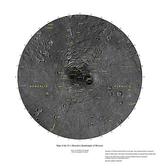
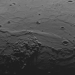
The Borealis quadrangle is a quadrangle on Mercury surrounding the north pole down to 65° latitude. It was mapped in its entirety by the MESSENGER spacecraft, which orbited the planet from 2008 to 2015, excluding areas of permanent shadow near the north pole. Only approximately 25% of the quadrangle was imaged by the Mariner 10 spacecraft during its flybys in 1974 and 1975. The quadrangle is now called H-1.

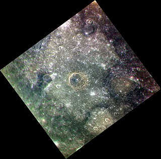
The Hokusai quadrangle (H-5) is one of fifteen quadrangles on the planet Mercury. It runs from 360 to 270° longitude and 20 to 70° latitude. Named after the Hokusai crater, it was mapped in detail for the first time after MESSENGER entered orbit around Mercury in 2011. It had not been mapped prior to that point because it was one of the six quadrangles that was not illuminated when Mariner 10 made its flybys in 1974 and 1975. These six quadrangles continued to be known by their albedo feature names, with this one known as the Apollonia quadrangle.

The Diacria quadrangle is one of a series of 30 quadrangle maps of Mars used by the United States Geological Survey (USGS) Astrogeology Research Program. The quadrangle is located in the northwestern portion of Mars' western hemisphere and covers 180° to 240° east longitude and 30° to 65° north latitude. The quadrangle uses a Lambert conformal conic projection at a nominal scale of 1:5,000,000 (1:5M). The Diacria quadrangle is also referred to as MC-2. The Diacria quadrangle covers parts of Arcadia Planitia and Amazonis Planitia.

Anseris Mons is an isolated massif (mountain) in the southern highlands of Mars, located at the northeastern edge of Hellas Planitia at longitude 86.65°E and latitude 29.81°S. The mountain is 58 km (36 mi) in diameter and rises to an elevation of approximately 4,200 m (13,780 ft) above datum or about 6,200 m (20,300 ft) above the surrounding plains. The mountain lies in the southeastern quarter of the Iapygia quadrangle (MC-21), straddling the boundary with the adjoining Hellas quadrangle (MC-28) to the south.

Elysium Planitia, located in the Elysium and Aeolis quadrangles, is a broad plain that straddles the equator of Mars, centered at 3.0°N 154.7°E. It lies to the south of the volcanic province of Elysium, the second largest volcanic region on the planet, after Tharsis. Elysium contains the major volcanoes Elysium Mons, Albor Tholus and Hecates Tholus. Another more ancient shield volcano, Apollinaris Mons, is situated just to the south of eastern Elysium Planitia. Within the plains, Cerberus Fossae is the only Mars location with recent volcanic eruptions. Lava flows dated no older than 0.2 million years from the present have been found, and evidence has been found that volcanic activity may have occurred as recently as 53,000 years ago. Such activity could have provided the environment, in terms of energy and chemicals, needed to support life forms.

Guinevere Planitia is an expansive lowland region of Venus that lies east of Beta Regio and west of Eistla Regio. These low-lying plains, particularly in the western portion, are characterized by apparent volcanic source vents and broad regions of bright, dark, and mottled deposits. They are the only break in an equatorially connected zone of highlands and tectonic zones. The types, numbers, and patterns of mapped tectonic features and small volcanic landforms in the region provide important detail in the interpretation and evolution of venusian landscape.

Ganis Chasma is a group of rift zones on the surface of the planet Venus. Bright spots detected by the Venus Monitoring Camera on the European Space Agency's Venus Express in the area suggest that there may be active volcanism on Venus.
Eridania Planitia is a plain located in the southern highlands of Mars. It borders the Hellas basin to the west, Promethei Terra to the south, and the massive shield volcano Hesperia Planum to the north. The name Eridania Planitia was approved by the International Astronomical Union (IAU) on 22 September 2010; it is named after the closest classical albedo feature.

Vulcan Planitia, or Vulcan Planum, is the unofficial name given to a large plain on the southern hemisphere of Pluto's moon Charon. It discovered by New Horizons during its flyby of Pluto in July 2015. It is named after the fictional planet Vulcan in the science-fiction series Star Trek. The name is not approved by International Astronomical Union (IAU) as of 2024.

Alver is a crater on Mercury. It has a diameter of 151.49 kilometers. Its name was adopted by the International Astronomical Union (IAU) on March 15, 2013. Alver is named for the Estonian poet Betti Alver.
Sihtu Planitia is a large plain on Mercury, approximately 565 km across. It was named in 2017 by the IAU. The crater Calvino lies at the center of the Planitia, and Rūdaki is on the east side.

Apārangi Planitia is a large plain on Mercury, approximately 1077 km across. It was named in 2017 by the IAU.

