Uvalda, Georgia

Last updated

Uvalda, Georgia
Uvalda City Hall.JPG
Uvalda City Hall
Montgomery County Georgia Incorporated and Unincorporated areas Uvalda Highlighted.svg
Location in Montgomery County and the state of Georgia
Coordinates: 32°2′16″N82°30′32″W / 32.03778°N 82.50889°W / 32.03778; -82.50889
Country United States
State Georgia
County Montgomery
Government
  MayorElaine Manning
Area
[1]
  Total1.91 sq mi (4.94 km2)
  Land1.89 sq mi (4.90 km2)
  Water0.01 sq mi (0.03 km2)
Elevation
177 ft (54 m)
Population
 (2020) [2]
  Total439
  Density231.91/sq mi (89.56/km2)
Time zone UTC-5 (Eastern (EST))
  Summer (DST) UTC-4 (EDT)
ZIP code
30473
Area code 912
FIPS code 13-78744 [3]
GNIS feature ID0324646 [4]

Uvalda is a city in Montgomery County, Georgia, United States. The population was 439 at the 2020 census, [2] down from 598 in 2010.

Contents

History

The community derives its name from Juan de Ugalde, a Texas pioneer. [5] The Georgia General Assembly incorporated Uvalda as a town in 1910. [6]

Geography

Uvalda is located in southern Montgomery County at 32°2′16″N82°30′32″W / 32.03778°N 82.50889°W / 32.03778; -82.50889 (32.037903, -82.508789). [7] U.S. Route 221 passes through the center of town, leading north-northwest 11 miles (18 km) to Mount Vernon, the county seat, and south-southwest 13 miles (21 km) to Hazlehurst. Georgia State Route 56 follows US 221 out of Uvalda to the northwest but also leads east 25 miles (40 km) to Reidsville. State Route 135 leads south to Hazlehurst with US 221 and north-northeast 13 miles (21 km) to Higgston.

According to the United States Census Bureau, Uvalda has a total area of 1.9 square miles (4.9 km2), of which 0.01 square miles (0.03 km2), or 0.68%, are water. [1] Milligan Creek flows through the city just east of its center, leading southeast to the Altamaha River.

Demographics

Historical population
CensusPop.Note
1920 240
1930 513113.8%
1940 59215.4%
1950 511−13.7%
1960 58915.3%
1970 66312.6%
1980 646−2.6%
1990 561−13.2%
2000 530−5.5%
2010 59812.8%
2020 439−26.6%
U.S. Decennial Census [8]

As of the census [3] of 2000, there were 530 people, 201 households, and 147 families residing in the city. By 2020, its population declined to 439.

Notable people

Related Research Articles

<span class="mw-page-title-main">Montgomery County, Georgia</span> County in Georgia, United States

Montgomery County is a county located in the central portion of the U.S. state of Georgia. As of the 2020 census, the population was 8,610. The county seat is Mount Vernon. Montgomery County is part of the Vidalia, GA micropolitan statistical area.

<span class="mw-page-title-main">Wheeler County, Georgia</span> County in Georgia, United States

Wheeler County is a county located in the central portion of the U.S. state of Georgia. As of the 2020 census, the population was 7,471. The county seat is Alamo. The county is one of the most impoverished counties in the nation. The American Community Survey's 2009–2013 average reports that the county's per-capita income of $8,948 makes it the poorest county in the United States by this metric. The measurement however is misleading as Wheeler County is the site of Wheeler Correctional Facility, a large prison with a capacity of 2,874 prisoners, about 40 percent of the county's total population. Most prisoners have little income. The prison was opened in 1998 and the prison population may also account for the increased population of the county in the early 2000s.

<span class="mw-page-title-main">Treutlen County, Georgia</span> County in Georgia, United States

Treutlen County is a county located in the east central portion of the U.S. state of Georgia. As of the 2020 census, the population was 6,406. The county seat is Soperton. It is host to the Million Pines Arts and Crafts Festival which occurs during the first weekend in November.

<span class="mw-page-title-main">Jeff Davis County, Georgia</span> County in Georgia, United States

Jeff Davis County is a county located in the southeastern part of the U.S. state of Georgia. As of the 2020 census, the population was 14,779. The county seat is Hazlehurst. The county was created on August 18, 1905, and named for Jefferson Davis, the only Confederate president.

<span class="mw-page-title-main">Alma, Georgia</span> City in Georgia, United States

Alma is a city in Bacon County, Georgia, United States, and the county seat. As of the 2020 census, the city had a population of 3,433.

<span class="mw-page-title-main">Adrian, Georgia</span> City in Georgia, United States

Adrian is a city in Emanuel and Johnson County, Georgia, United States. As of the 2020 census, the city had a population of 552.

<span class="mw-page-title-main">Stillmore, Georgia</span> City in Georgia, United States

Stillmore is a city in Emanuel County, Georgia, United States. The population was 439 in 2020.

<span class="mw-page-title-main">Kite, Georgia</span> City in Georgia, United States

Kite is a city in Johnson County, Georgia, United States, along the Little Ohoopee River. The population was 160 in 2020.

<span class="mw-page-title-main">Wrightsville, Georgia</span> City in Georgia, United States

Wrightsville is a city in and the county seat of Johnson County, Georgia, United States. The population was 2,195 at the 2010 census, down from 2,223 at the 2000 census. By 2020, its population grew to 3,449. The city limits include Johnson State Prison on the northeast side of town. Wrightsville is part of the Dublin Micropolitan Statistical Area.

<span class="mw-page-title-main">Lincolnton, Georgia</span> City in Georgia, United States

Lincolnton is a city and the county seat of Lincoln County, Georgia, United States. The population was 1,480 at the 2020 census. It contains numerous houses and historic districts listed on the National Register of Historic Places. Both the city and the county were named for General Benjamin Lincoln, who served in the Continental Army during the American Revolution.

<span class="mw-page-title-main">Woodbury, Georgia</span> City in Georgia, United States

Woodbury is a city in Meriwether County, Georgia, United States. The population was 908 at the 2020 census.

<span class="mw-page-title-main">Ailey, Georgia</span> City in Georgia, United States

Ailey is a city in Montgomery County, Georgia, United States. As of the 2020 census, the city had a population of 519, up from 432 in 2010.

<span class="mw-page-title-main">Alston, Georgia</span> Town in Georgia, United States

Alston is a town in Montgomery County, Georgia, United States, with a population of 178 at the 2020 census.

<span class="mw-page-title-main">Higgston, Georgia</span> Town in Georgia, United States

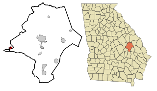
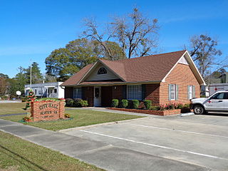
Higgston is a town in Montgomery County, Georgia, United States. The population was 314 at the 2020 census.

<span class="mw-page-title-main">Mount Vernon, Georgia</span> City in Georgia, United States

Mount Vernon is a city in, and the county seat of, Montgomery County, Georgia, United States. The population was 1,900 at the 2020 census, down from 2,451 in 2010. It is home to Brewton–Parker College.

<span class="mw-page-title-main">Tarrytown, Georgia</span> Town in Georgia, United States

Tarrytown is a town in Montgomery County, Georgia, United States. The population was 66 at the 2020 census, down from 87 in 2010.

<span class="mw-page-title-main">Lumber City, Georgia</span> City in Georgia, United States

Lumber City is a city located in Telfair County, Georgia, United States. As of the 2020 census, the city had a total population of 967.

<span class="mw-page-title-main">McRae, Georgia</span> City in Georgia, United States

McRae was a city in and the county seat of Telfair County, Georgia, United States. It was designated as the seat in 1871, after being established the previous year as a station on the Macon and Brunswick Railroad. Upon the city's merger with adjacent Helena in 2015, the new county seat is the combined city of McRae-Helena.

<span class="mw-page-title-main">Beechwood Trails, Ohio</span> Census-designated place in Ohio, United States

Beechwood Trails is a census-designated place (CDP) in Harrison Township, Licking County, Ohio, United States. The population was 3,276 at the 2020 census.

<span class="mw-page-title-main">Georgia State Route 135</span> State highway in Georgia, United States

State Route 135 (SR 135) is a 130-mile-long (210 km) state highway in the south-central part of the U.S. state of Georgia. It connects the Florida state line with Higgston, via Lakeland, Willacoochee, Douglas, and Hazlehurst. It travels concurrently with U.S. Route 221 for extensive distances, a short piece in Lakeland and a longer one from Douglas to Uvalda.

References

  1. 1 2 "2022 U.S. Gazetteer Files: Georgia". United States Census Bureau. Retrieved January 30, 2023.
  2. 1 2 "P1. Race – Uvalda city, Georgia: 2020 DEC Redistricting Data (PL 94-171)". U.S. Census Bureau. Retrieved January 30, 2023.
  3. 1 2 "U.S. Census website". United States Census Bureau . Retrieved January 31, 2008.
  4. "US Board on Geographic Names". United States Geological Survey. October 25, 2007. Retrieved January 31, 2008.
  5. Krakow, Kenneth K. (1975). Georgia Place-Names: Their History and Origins (PDF). Macon, GA: Winship Press. p. 239. ISBN   0-915430-00-2.
  6. Georgia (1910). Acts and Resolutions of the General Assembly of the State of Georgia. p. 1224.
  7. "US Gazetteer files: 2010, 2000, and 1990". United States Census Bureau. February 12, 2011. Retrieved April 23, 2011.
  8. "Census of Population and Housing". Census.gov. Retrieved June 4, 2015.