
Palakkad is one of the 14 districts in the Indian state of Kerala. It was carved out of the southeastern region of the former Malabar District on 1 January 1957. It is located at the central region of Kerala and is the second largest district in the state after Idukki. The city of Palakkad is the district headquarters. Palakkad is bordered on the northwest by the Malappuram district, on the southwest by the Thrissur district, on the northeast by Nilgiris district, and on the east by Coimbatore district of Tamil Nadu. The district is nicknamed "The granary of Kerala". Palakkad is the gateway to Kerala due to the presence of the Palakkad Gap, in the Western Ghats. The 2,383 m high Anginda peak, which is situated in the border of Palakkad district, Nilgiris district, and Malappuram district, in Silent Valley National Park, is the highest point of elevation in Palakkad district. Palakkad city is about 347 kilometres (216 mi) northeast of the state capital, Thiruvananthapuram.

Thirunellai (translit=Tirunellāyi) is a residential area in Palakkad district, Kerala, India. It is located on the banks of the Kannadi River and is about five kilometers from the district headquarters. It comes under the Kannadi Panchayath. It is about 4km from Kuzhalmannam.
Akathethara is a census town and suburb of Palakkad city, Kerala, India. It is located about 11 km from the city centre and 5 km from renowned Malampuzha dam. Sabari Ashram also called as Kerala's Sabarmati is located here where Mahatma Gandhi made his visit three times.
Vadakkencherry is a town and gram panchayat in the Palakkad district, state of Kerala, India. It is located about 35 km from Palakkad along National Highway 544. Vadakkencherry-Mannuthy section of NH-544 is the first six lane National Highway in the state.

Palakkad, also known as Palghat, historically known as Palakkattussery, is a municipality in the Indian state of Kerala. It is the administrative headquarters of Palakkad District. Palakkad is the most densely populated municipality and the fourth-most densely populated city in the state. It was established before Indian independence under British rule and known by the name Palghat. Palakkad is famous for the ancient Palakkad Fort, which is in the heart of the city and was captured and rebuilt by Hyder Ali in 1766 which later fell into the hands of Zamorin in 1784. The city is about 347 kilometres (216 mi) northeast of the state capital, Thiruvananthapuram.

Chittur-Thathamangalam is a town and municipality in Palakkad district of Kerala State, India. It is the headquarters of Chittur taluk, 13 km (8.1 mi) south-east of Palakkad, on the banks of the Kannadipuzha, a major headstream of the Bharathapuzha, the second longest river in Kerala. A Mini Civil Station is also located here which provides government related services. It consists of two areas, Chittur and Thathamangalam which together form the municipality.
Vengad is a gram panchayat situated in Thalassery taluk, Kannur district, Kerala, India, on the banks of the Anjarakandi River. Vengad is famous for its black pepper and handloom. One state seed farm is located in Vengad. Vengad gram panchayat consists of 21 wards; viz Pattathari (1), Kallayi (2), Vengad Angadi (3), Vengad Metta (4), Vengad Theru (5), Oorppalli (6), Kaitheripoyil (7), Valankichal (8), Pathiriyad (9), Pachapoika (10), Parambayi (11), Kelalur (12), Mambaram (13), Poyanad (14), Keezhathur Balavadi (15), Keezhathur Vayanasala (16), Kuzhiyil Peedika (17), Mailulli (18), Kunnirikka (19), Paduvilayi (20) and Thattari (21).
Nurani is a major commercial and residential area in Palakkad city Kerala, India. It is located along Palakkad Ponnani road which connects further to NH 66.Nurani is ward 39 of Palakkad Municipality. It also contains a heritage village populated mainly by Tamil Brahmins.
Ayyapuram is an area in Palakkad city,Kerala, India. The area derives its name from the Ayyappan temple that is located nearby. History is that the whole area belonged to this temple.Ayyapuram is wards 4 and 15 of Palakkad Municipality.

Shekharipuram(also spelled as Sekharipuram) is a residential area in Palakkad, in the Indian state of Kerala. Sekharipuram is famous for its agraharam(heritage village). The Calicut bypass road which starts from Sekharipuram is a 4 lane bypass road constructed for the vehicles coming from other parts of Kerala going towards Tamil Nadu side by bypassing Palakkad town.
Ayiloor, also known as Ayilur, Aylur, or Ayalur, is a village in the Chittur Thaluk of Palakkad district, state of Kerala, India. Ayiloor is located about 30 kilometers away from Palakkad town and 48 kilometers from Thrissur town.
Pirayiri is a residential and commercial area in Palakkad city. It is located about 8 km (5.0 mi) from the city centre.It belongs to Pirayiri gram panchayat in the Palakkad district, state of Kerala, India.

Puthur is a residential area in the Palakkad district, in the state of Kerala, India. Puthur is comprises of the wards 12 and 13 of Palakkad Municipality.

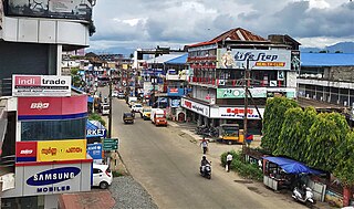
Kanjikode or Kanchikode is an industrial town located 13 km (8.1 mi) east of Palakkad. Kanjikode is the second largest industrial hub in Kerala after Kochi. The town is part of Pudussery Panchayat. It is one of the growing suburbs of Palakkad city. First and the only Indian Institute of Technology in Kerala, Indian Institute of Technology,Palakkad was established in Kanjikode. The upcoming Industrial Smart City project is going to be established in Kanjikode.

Perinthalmanna is a major town and municipality in Malappuram district, Kerala, India. It serves as the administrative centre for the Perinthalmanna taluk, as well as a revenue division, a community development block, and a police sub-division bearing the same name. It was formerly the headquarters of Valluvanad Taluk, which was one of the two Taluks in the Malappuram Revenue Division of the erstwhile Malabar District during the British Raj. The city is located 23 kilometres (14 mi) southwest of the city of Malappuram at the centre of the Kozhikode–Malappuram–Perinthalmanna–Palakkad National Highway 966.
Jainamedu is a suburb or neighbourhood of Palakkad city, Kerala, India, and is located on the southern banks of the Kalapathy River. It is one of the western suburbs of Palakkad and is ward 51 of Palakkad Municipality.
Kongad is a town and gram panchayat in Palakkad taluk, Kerala, India. It is a local government organisation that serves the villages of Kongad-I and Kongad-II. Kongad is located about 18 km from the district headquarters Palakkad.

Kunnathurmedu is a commercial, residential and institutional area in Palakkad city, Kerala, India. It mainly consists of residential colonies and apartments. Kunnathurmedu is wards 23 and 24 of Palakkad Municipality. Several offices related to the Police service of the city including Palakkad South and Traffic Police stations are situated here.
Kallekulangara is an area in Palakkad city, Kerala, India. Kallekulangara is famous for Sree Emoor Bhagavathy temple which is believed to be consecrated by Parashurama and Hemambika Devi is the deity,due to this Kallekulangara is also known by Hemambika Nagar. Head office of Palakkad railway division of Southern Railway zone and a residential colony of the railway employees under Southern Railway known as Hemambika Nagar railway colony is located here.
Vennakkara is an area in Palakkad city, Kerala, India. It is located about 5 km (3.1 mi) from the city centre. Vennakkara is wards 32 and 33 of Palakkad Municipality.

