
Ambalappuzha is a small town in the Alappuzha district of Kerala state, India. It is located 14 km (8.7 mi) south of Alleppy city. which is the district headquarters.

Azhikode is a coastal town situated in Kannur district of Kerala, India. Azhikode town is divided into Azhikode North and Azhikode South. The northern end of the Azhikode North is called Azhikkal. The place is the birthplace of Sukumar Azhikode, an influential thinker and literary critic. It is about 12 km (7.5 mi) from Kannur city.

New Mahe is a census town in Thalassery taluk of Kannur district in the Indian state of Kerala. It is part of Greater Mahé Region.

Kumily also spelt as Kumaly is a revenue village and Gram Panchayat in the Idukki district of Kerala. It is a town in Cardamom Hills near Thekkady and Periyar Tiger Reserve. Kumily is a gateway town into Kerala from Tamil Nadu.

Kasaragod is one of the 14 districts in the southern Indian state of Kerala. Its northern border Thalappady is located just 10 km south to Ullal, which is the southernmost portion of the major port city Mangalore, on the southwestern Malabar coast of India.
Pothanikkad or Pothanicad is a village in Ernakulam district in the Indian state of Kerala. It's also the first village to achieve 100% literacy in India. However, In 2011, literacy rate of Mallappally village was 96.92 % compared to 94.00 % of Kerala, the highest in India. In Mallappally Male literacy stands at 96.85 % while female literacy rate was 96.99 %. Back to the village, the name Pothanikkad derives from the Malayalam words poth, meaning buffalo, anaa, meaning elephant, and kaddu, meaning forest, as it was originally a forest with wild buffalos and elephants. Now, this small village has developed into one of the most educated and culturally advanced villages in Kerala. St. Mary's High School is the oldest high school in Pothanicad, where very prominent people in the society and many local politicians have been educated. St. John's Higher Secondary school Pulinthanam is a pioneering educational institution in the village. A government Lower Primary school and two other private Senior Secondary High schools, following CBSE curriculum, also provides better educational opportunities for the young community.

Alakode is a emerging big town in Kannur district in the Indian state of Kerala. It is located 46 km towards North of District headquarters Kannur. Alakode is located on Taliparamba-Manakadavu-Coorg Road. Alakode was one of the major centers of Malabar Migration.
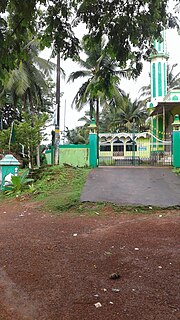
Kurumathur is a census town in Taliparamba taluk of Kannur district in Kerala state, India. Kurumathur is located 8 km (5.0 mi) east of Taliparamba town in SH 36.
Karadka is a village, block panchayat and grama panchayat in Kasaragod district in the state of Kerala, India.
Clappana is a village in Kollam district in the state of Kerala, India. Thottathil mukku and Puthan Pura Mukku is one of the major junctions in the village.
Edamulackal is a village in Kollam district in the state of Kerala, India. Situated near the second fastest growing town of Kerala, Anchal, the village, still retaining all the natural and scenic beauty of a typical Kerala village, is developing fast in education and service sectors too. The greeny slightly uneven terrain supports a wide range of agricultural activities, supported by the waters of Ithikkara river.
Elampalloor is an urban village in Kollam district in the state of Kerala and is a part of Kollam Metropolitan Area, India. It is 12 km away from Kollam city, 23 km away from Paravur and 13 km away from Kottarakkara.
Mulavana is a village in Kollam district in the state of Kerala, India. The place is filled with almost all types of shops,which includes stationary,fancy,textile etc. The Mulavana fish market is regarded as the best market while comparing with the surrounding places.
Thodiyoor is a village in Kollam district in the state of Kerala, India.
Vazhoor is a town in Kottayam district in the state of Kerala, India.It is a village, panchayat and block with headquarters at Kodungoor on NH183. Basically an agrarian community inhabits this part, whose income depends on rubber cultivation

Purathur is a beautiful sandy coastal village and a Grama Panchayat in Tirur Taluk, Malappuram district in the state of Kerala, India. Bharathappuzha river and Tirur River merges together in Purathur and join with the Arabian Sea at Padinjarekara Azhimukham, which is also the southernmost tip of Purathur Gram panchayat. Opposite to Padinjarekara Azhimukham is Ponnani port. The village is located at the southernmost tip of Tirur Taluk and is bordered by historically important Ponnani port in Ponnani Municipality of Ponnani taluk to south.
Thalikulam is a village in Thrissur district in the state of Kerala, India.

The Malappuram Metropolitan Area or Malappuram Urban Agglomeration is an urban agglomeration centred around the city of Malappuram, in Malappuram district, Kerala, India. It is the 25th largest urban agglomeration in India and the 4th largest in Kerala.
Kannur taluk is an administrative division of Kannur district of Kerala, India. Kannur district is divided into five taluks, Thalassery, Kannur, Payyanur, Iritty and Taliparamba. Thalassery has 35 villages, Kannur has 28, Payyanur has 22, Taliparamba has 28 villages and Iritty has 19 villages.
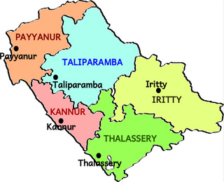
Taliparamba taluk is one of the five taluks in Kannur district in the state of Kerala, India. It borders Payyanur Taluk in the north, Kannur taluk and Thalassery taluk in the south and Iritty taluk in the east. It is a revenue division for the ease of administrative purposes, and is headquartered in Taliparamba. Most government offices are in the Mini Civil Station in Taliparamba. Taliparamba taluk consists of Taliparamba Municipality, Anthoor Municipality, Sreekandapuram Municipality and 15 surrounding panchayats.

