Related Research Articles


Northfield is a residential area in outer south Birmingham, England, and near the boundary with Worcestershire. It is also a council constituency, managed by its own district committee. The constituency includes the wards of Kings Norton, Longbridge, Weoley Castle and the smaller ward of Northfield that includes West Heath and Turves Green.

Kings Norton, alternatively King's Norton, is an area of Birmingham, England. Historically in Worcestershire, it was also a Birmingham City Council ward within the Government of Birmingham, England. The district lies 6.5 miles south-southwest of Birmingham city centre and is within 1.5 miles of the north Worcestershire border. Kings Norton has been split into two wards, Kings Norton North and Kings Norton South.

Wythall is a village and civil parish in the Bromsgrove District, in the north-east corner of the county of Worcestershire, England. Wythall parish borders Solihull and Birmingham, and had a population of 12,269 in the UK census of 2021.
New Frankley in Birmingham is a civil parish in Birmingham, England. As such, it has its own parish council.

Hollywood is a large village predominantly located in the Bromsgrove district of Worcestershire, England, almost contiguous with and to the south of the city of Birmingham. Hollywood was formerly part of Kings Norton, but when Birmingham expanded in 1911, Hollywood remained in Worcestershire. The village now lies across the wards of Hollywood, most of Drakes Cross, the Trueman's Heath polling district area of Trueman's Heath parish ward and, following a 1966 border change, the southern portion of the Birmingham Highter's Heath ward, with all but the latter being located within the civil parish of Wythall. The southern part of the village is also known as Drakes Cross, whilst the eastern part is sometimes referred to as Trueman's Heath. Hollywood is situated in the extreme northeastern corner of Worcestershire, 8.5 miles / 13 km south of Birmingham city centre, 6 miles / 9.5 km west-southwest of Solihull and 8 miles / 12.5 km northeast of Redditch.

Rednal is a residential suburb on the south western edge of metropolitan Birmingham, West Midlands, England, 9 miles southwest of Birmingham city centre and forming part of Longbridge parish and electoral ward.

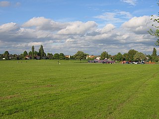
West Heath is a residential area of Birmingham, England on the boundary with Worcestershire. Forming the larger part of the ward of Longbridge And West Heath it is situated between Kings Norton, Northfield, Longbridge and Cofton Hackett and lies on traditional heathland formed in the 13th century as part of the Kings Norton manorial lands, and was historically in Worcestershire.

Bromsgrove is a constituency in Worcestershire represented in the House of Commons of the UK Parliament since 2010 by Sajid Javid of the Conservative Party. Javid formerly served as Chancellor of the Exchequer, Home Secretary and Health Secretary.

Longbridge is an area in the south-west of Birmingham, England, located near the border with Worcestershire.

Kings Norton railway station serves the Kings Norton and Cotteridge areas of Birmingham, England. It lies on the Cross-City Line from Redditch and Bromsgrove through Birmingham New Street to Lichfield. The station's main entrance is located on Pershore Road South, the A441.
Bromsgrove District Council elections are held every four years. Bromsgrove District Council is the local authority for the non-metropolitan district of Bromsgrove in Worcestershire, England. Since the last boundary changes in 2015, 31 councillors are elected from 30 wards.

King's Norton and Northfield Urban District was a local government administrative district in north Worcestershire, England, from 1898 until 1911. Much of its area was afterwards absorbed into the neighbouring Borough of Birmingham, under the Greater Birmingham Scheme, and now constitutes most of the city's southern and southwestern suburban environs.

Rubery is a village in the Bromsgrove District and a suburb of Birmingham in the counties of Worcestershire and West Midlands, England. It is 9 miles (14 km) from Birmingham city centre and a similar distance from Bromsgrove.

The administrative boundaries of Worcestershire, England have been fluid for over 150 years since the first major changes in 1844. There were many detached parts of Worcestershire in the surrounding counties, and conversely there were islands of other counties within Worcestershire. The 1844 Counties Act began the process of eliminating these, but the process was not completed until 1966, when Dudley was absorbed into Staffordshire.
Kings Heath is a suburb of south Birmingham, England, four miles south of the city centre. Historically in Worcestershire, it is the next suburb south from Moseley on the A435 Alcester Road. Since 2018 it has been part of the Brandwood and Kings Heath Ward.
Highter's Heath is a district and ward lying on the southern boundary of the city of Birmingham, UK. The district of Highter's Heath lies immediately east of the Maypole. The first recorded use of the name dates from 1495 as Heyters Heath, however today the name is not one that is particularly in widespread use, indeed only three signposted references to the name exist, when entering the city along Maypole Lane, when entering the city from the bottom of Highters Heath Lane and in Major's Green.
Major's Green is a village in the Wythall parish of Bromsgrove district and is the northeastern-most settlement in the county of Worcestershire, England.
References
- ↑ "Kings Norton South ward map" (PDF).
- ↑ "Wythall West ward map" (PDF).
- ↑ "LGBCE report 683, Aug 1992" (PDF). Archived from the original (PDF) on 14 April 2021.
- ↑ "Bromsgrove DC - Maximum Electorates and Polling Stations May 2019" (PDF).

52°24′19″N1°54′52″W / 52.4052°N 1.9144°W
| | This West Midlands location article is a stub. You can help Wikipedia by expanding it. |