Related Research Articles

Harden–Murrumburrah is a township and community in the Hilltops Region and is located in the South West Slopes of New South Wales in Australia. Harden is adjacent to both the Canberra region of the Australian Capital Territory and the Riverina Region in the southwest area of NSW. The town is a twin town between Harden and Murrumburrah.

Branxton is a town in the Hunter Region of New South Wales, Australia. Branxton is 171 kilometres (106 mi) north of Sydney via the Sydney–Newcastle Freeway and New England Highway. Branxton is located mostly in the City of Cessnock, but part of it is in Singleton Shire.
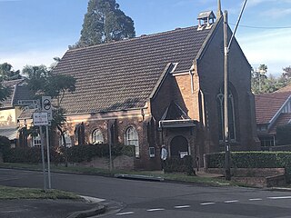
Artarmon is a suburb on the lower North Shore of Sydney, in the state of New South Wales, Australia, 9 kilometres north-west of the Sydney central business district, in the local government area of the City of Willoughby.

Zetland is an inner southern suburb of Sydney, New South Wales, Australia 4 kilometres south of the Sydney central business district, in the local government area of the City of Sydney. The postcode is 2017.

Carlton is a suburb in southern Sydney, in the state of New South Wales, Australia. Carlton is located 15 kilometres south of the Sydney central business district and is part of the St George area. Carlton lies across the boundary of two local government areas, the Georges River Council and the Bayside Council.
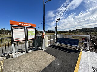
Wallarobba railway station is located on the North Coast line in New South Wales, Australia opening on 4 August 1911. It serves the rural locality of Wallarobba. Originally a full-length platform with wooden station buildings it was later replaced by the present short platform. It is serviced by NSW TrainLink Hunter line services travelling between Newcastle and Dungog.
Speers Point is a suburb of Greater Newcastle, and the location of the council seat of the City of Lake Macquarie local government area in New South Wales, Australia. It is 17 kilometres (10.6 mi) west-southwest of the city of Newcastle on the northern shore of Lake Macquarie, in Cockle and Warners Bays, between the suburbs of Cardiff and Warners Bay.

Port Stephens Council is a local government area in the Hunter Region of New South Wales, Australia. The area is just north of Newcastle and is adjacent to the Pacific Highway which runs through Raymond Terrace, the largest town and Council seat. The area is named after Port Stephens, which is the major geographical feature of the area. It extends generally from the Hunter River in the south, to near Clarence Town in the north, and from the Tasman Sea in the east, to just south of Paterson in the west. The mayor of Port Stephens Council is Ryan Palmer. Palmer was caught in a major scandal in 2022 following the purchase of an $86,000 Ford Ranger for mayoral and personal use. Port Stephens is about two and a half hours north of Sydney.

The City of Maitland is a local government area in the lower Hunter region of New South Wales, Australia. The area is situated adjacent to the New England Highway and the Hunter railway line.

Dungog Shire is a local government area in the Hunter region of New South Wales, Australia. The Shire is situated adjacent to the Barrington Tops and consists predominantly of very rugged to hilly country which becomes less rugged from north to south.
Thornton is a suburb in the City of Maitland, New South Wales, Australia. It is bisected by the New England Highway.
Telarah is a suburb in the City of Maitland, New South Wales, Australia. The suburb was formerly known as Homeville, however use of this name was abandoned in the 1950s. It is located on the New England Highway and is also the site of a major rail junction, where the North Coast line and the once extensive, privately owned South Maitland Railway system meet the Main North line. A station on the North Coast line opened in 1911 and is served by NSW TrainLink's Hunter Line, with services to Newcastle and Dungog. Telarah has its own fire brigade as well as bowling club, supermarket, pharmacy, takeaway shop and petrol station.
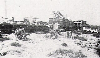
Pelaw Main is a hamlet a few kilometres south-west of Kurri Kurri, in the Hunter Region of New South Wales, Australia. It owes its origins entirely to the colliery there of the same name. It had a population of 1,027 in 2011
Martins Creek is a small country town located between Dungog and Maitland in the Hunter Region of Australia.
Glen Martin is a scattered rural community located within the Hunter Region of New South Wales, Australia. It is part of the Dungog local government area.
Oakhampton is a suburb in the City of Maitland in the Hunter Region of New South Wales, Australia.
Mindaribba is a suburb in the City of Maitland in the Hunter Region of New South Wales, Australia. It is located on the eastern side of the Hunter River, approximately 9 km north of the Maitland central business district.
Hilldale is a small country town located between Dungog and Maitland in the Hunter Region of Australia. Hilldale had a population of 193 people in the 2021 Census.
Wirragulla is a small country town located between Dungog and Maitland in the Hunter Region of Australia. Wirragulla had a population of 25 people in the 2021 Census.
Tabbil Creek is a small country town located between Dungog and Maitland in the Hunter Region of Australia. Tabbil Creek had a population of 53 people in the 2021 Census. Tabbil Creek includes a cemetery and a golf club.
References
- ↑ Australian Bureau of Statistics (28 June 2022). "Wallarobba (suburb and locality)". Australian Census 2021 QuickStats. Retrieved 28 June 2022.
- ↑ "2021 Wallarobba, Census All persons QuickStats | Australian Bureau of Statistics". www.abs.gov.au. Retrieved 2023-11-10.
- ↑ "Three seriously injured after train hits car in NSW Hunter region". www.9news.com.au. 2021-06-22. Retrieved 2023-11-10.
32°29′49″S151°41′46″E / 32.49694°S 151.69611°E
| | This Dungog Shire geography article is a stub. You can help Wikipedia by expanding it. |