Warrensburg, Illinois | |
---|---|
Coordinates: 39°55′52″N89°3′41″W / 39.93111°N 89.06139°W | |
Country | United States |
State | Illinois |
County | Macon |
Township | Illini |
Area | |
• Total | 0.73 sq mi (1.89 km2) |
• Land | 0.73 sq mi (1.89 km2) |
• Water | 0.00 sq mi (0.00 km2) |
Elevation | 700 ft (200 m) |
Population | |
• Total | 1,110 |
• Density | 1,524.73/sq mi (588.30/km2) |
Time zone | UTC-6 (CST) |
• Summer (DST) | UTC-5 (CDT) |
ZIP code | 62573 |
Area code | 217 |
FIPS code | 17-78916 |
Website | warrensburgil |
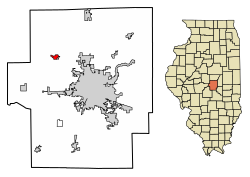
Warrensburg is a village in Macon County, Illinois, United States. Its population was 1,110 at the 2020 census, [2] down from 1,201 in 2010. It is included in the Decatur, Illinois Metropolitan Statistical Area. Warrensburg was established in 1841.
Warrensburg is located in northwestern Macon County at 39°55′52″N89°3′41″W / 39.93111°N 89.06139°W (39.931102, -89.061326). [3] Illinois Route 121 passes through the northeast side of the village, leading southeast 9 miles (14 km) to Decatur, the county seat, and northwest 14 miles (23 km) to Mount Pulaski.
According to the U.S. Census Bureau, Warrensburg has a total area of 0.73 square miles (1.89 km2), all land. [1]
Census | Pop. | Note | %± |
---|---|---|---|
1900 | 503 | — | |
1910 | 504 | 0.2% | |
1920 | 490 | −2.8% | |
1930 | 517 | 5.5% | |
1940 | 456 | −11.8% | |
1950 | 549 | 20.4% | |
1960 | 681 | 24.0% | |
1970 | 811 | 19.1% | |
1980 | 1,372 | 69.2% | |
1990 | 1,274 | −7.1% | |
2000 | 1,289 | 1.2% | |
2010 | 1,210 | −6.1% | |
2020 | 1,110 | −8.3% | |
U.S. Decennial Census [4] |
As of the census [5] of 2000, there were 1,289 people, 500 households, and 364 families residing in the village. The population density was 1,900.6 inhabitants per square mile (733.8/km2). There were 527 housing units at an average density of 777.0 per square mile (300.0/km2). The racial makeup of the village was 97.67% White, 0.62% African American, 0.31% Native American, 0.23% Asian, 0.08% from other races, and 1.09% from two or more races. Hispanic or Latino of any race were 0.47% of the population.
There were 500 households, out of which 35.8% had children under the age of 18 living with them, 58.6% were married couples living together, 10.2% had a female householder with no husband present, and 27.2% were non-families. 22.4% of all households were made up of individuals, and 7.8% had someone living alone who was 65 years of age or older. The average household size was 2.56 and the average family size was 3.03.
In the village, the population was spread out, with 27.0% under the age of 18, 8.2% from 18 to 24, 31.1% from 25 to 44, 25.0% from 45 to 64, and 8.7% who were 65 years of age or older. The median age was 35 years. For every 100 females, there were 95.0 males. For every 100 females age 18 and over, there were 97.3 males.
The median income for a household in the village was $45,708, and the median income for a family was $51,458. Males had a median income of $40,341 versus $22,688 for females. The per capita income for the village was $19,041. About 2.4% of families and 3.7% of the population were below the poverty line, including 3.5% of those under age 18 and 2.2% of those age 65 or over.
Macon County is a county located in the U.S. state of Illinois. According to the 2020 United States Census, it had a population of 103,998. Its county seat and most populous city is Decatur.
Lostant is a village in LaSalle County, Illinois, United States. The population was 423 at the 2020 census, down from 498 at the 2010 census. It is part of the Ottawa Micropolitan Statistical Area.
Latham is a village in Logan County, Illinois, United States. The population was 380 at the 2010 census.
Argenta is a village in Macon County, Illinois, United States, whose population was 913 at the 2020 census. It is included in the Decatur, Illinois Metropolitan Statistical Area.
Blue Mound is a village in Macon County, Illinois, United States. The population was 1,133 at the 2020 census. It is included in the Decatur, Illinois Metropolitan Statistical Area.
Forsyth is a village in Macon County, Illinois, United States. Its population was 3,734 at the 2020 census, up from 3,490 in 2010. It is included in the Decatur, Illinois Metropolitan Statistical Area.
Harristown is a village in Macon County, Illinois, United States. The population was 1,310 at the 2020 census. It is included in the Decatur, Illinois Metropolitan Statistical Area.
Long Creek is a village in Macon County, Illinois, United States. As of the 2020 census there were 1,261 people. It is included in the Decatur, Illinois Metropolitan Statistical Area.
Macon is a town in Macon County, Illinois, United States whose population was 1,177 at the 2020 census. It is included in the Decatur, Illinois Metropolitan Statistical Area and lies 9 miles (14 km) south of Decatur.
Maroa is a city in Macon County, Illinois, United States. Its population was 1,577 at the 2020 census, down from 1,801 in 2010. It is included in the Decatur, Illinois Metropolitan Statistical Area.
Niantic is a village in Macon County, Illinois, United States. Its population was 612 at the 2020 census, down from 707 in 2010. It is included in the Decatur, Illinois Metropolitan Statistical Area.
Oreana is a village in Macon County, Illinois, United States, which had a population of 891 at the 2020 census. It is included in the Decatur, Illinois Metropolitan Statistical Area.
East Gillespie is a village in Macoupin County, Illinois, United States. As of the 2020 census, the village had a population of 269.
Modesto is a village in Macoupin County, Illinois, United States. The population was 182 at the 2020 census, down from 252 in 2000.
Sawyerville is a village in Macoupin County, Illinois, United States. As of the 2020 census the population was 268.
Standard City is a village in Macoupin County, Illinois, United States. The population was 135 at the 2020 census.
Wilsonville is a village in Macoupin County, Illinois, United States. The population was 536 at the 2020 census.
Dalton City is a village in Moultrie County, Illinois, United States. It is in the center of the state near the Macon County line. The population was 454 at the 2020 census, down from 544 in 2010.
Birnamwood is a village in Marathon and Shawano counties in the U.S. state of Wisconsin. It is part of the Wausau, Wisconsin Metropolitan Statistical Area. The population was 818 at the 2010 census. Of this, 802 were in Shawano County, and 16 were in Marathon County. The village is located mostly within the town of Birnamwood in Shawano County; only a small portion extends into the town of Norrie in adjacent Marathon County.
Mount Zion is a village in Macon County, Illinois, United States. The population was 6,019 at the 2020 census.