Lawrence is a city located in Essex County, Massachusetts, United States, on the Merrimack River. At the 2020 census, the city had a population of 89,143. Surrounding communities include Methuen to the north, Andover to the southwest, and North Andover to the east. Lawrence and Salem were the county seats of Essex County, until the state abolished county government in 1999. Lawrence is part of the Merrimack Valley.

Methuen is a 23-square-mile city in Essex County, Massachusetts, United States. The population was 53,059 at the 2020 census. Methuen lies along the northwestern edge of Essex County, just east of Middlesex County and just south of Rockingham County, New Hampshire. The city is bordered by Haverhill to the northeast, North Andover to the southeast, Lawrence and Andover to the south, Dracut to the west, Pelham, New Hampshire to the northwest, and Salem, New Hampshire to the north. Methuen is located 17 miles (27 km) southwest from Newburyport, 30 miles (48 km) north-northwest of Boston and 25 miles (40 km) south-southeast of Manchester, New Hampshire.

North Andover is a town in Essex County, Massachusetts, United States. At the 2020 census, the population was 30,915.

Dracut is a town in Middlesex County, Massachusetts, United States. At the 2020 census, the town's population was 32,617, making it the second most populous town in Massachusetts with an open town meeting system of governance. The town covers a total area of 21.36 square miles, 0.5 square miles of which are water.

Lowell is a city in Massachusetts, United States. Alongside Cambridge, it is one of two traditional seats of Middlesex County. With an estimated population of 115,554 in 2020, it was the fifth most populous city in Massachusetts as of the last census, and the third most populous in the Boston metropolitan statistical area. The city is also part of a smaller Massachusetts statistical area, called Greater Lowell, and of New England's Merrimack Valley region.
Lowell National Historical Park is a National Historical Park of the United States located in Lowell, Massachusetts. Established in 1978 a few years after Lowell Heritage State Park, it is operated by the National Park Service and comprises a group of different sites in and around the city of Lowell related to the era of textile manufacturing in the city during the Industrial Revolution. In 2019, the park was included as Massachusetts' representative in the America the Beautiful Quarters series.

Spring Hill is a ridge in the central part of the city of Somerville, Massachusetts, United States, and the residential neighborhood that sits atop it. It runs northwest to southeast, roughly bounded by Highland Avenue, Somerville Avenue, Elm Street, and Willow Avenue. Summer Street runs along the hill's crest.

North Billerica is an unincorporated village of the town of Billerica, Massachusetts, United States, one of the nine sections (hamlets) that make up the Town of Billerica. It is the home to Faulkner and Talbot mills and the North Billerica Train Depot. The Middlesex Canal was built through the village in 1783 and the Boston and Lowell Railroad was put through in the 1840s.
The Thomas Aspinwall Davis House is a historic house at 29 Linden Place in Brookline, Massachusetts. The house was built in 1844, by Thomas Aspinwall Davis, later a mayor of Boston, and is one of the earliest buildings to survive from his Linden Park project, the first residential subdivision in Brookline. The house was listed on the National Register of Historic Places in 1985.
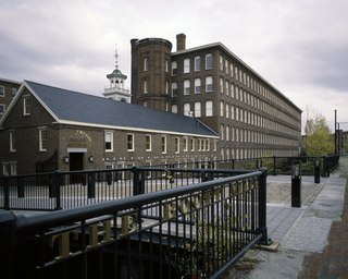
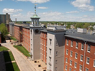
The Boott Mills in Lowell, Massachusetts were a part of an extensive group of cotton mills, built in 1835 alongside a power canal system in this important cotton town. Its incorporators were Abbott Lawrence, Nathan Appleton, and John Amory Lowell, and is named after Kirk Boott, the first Agent of the Proprietors of Locks & Canals in Lowell. Today, the Boott Mills complex is the most complete remainder of antebellum textile mills built in Lowell. The original Mill No. 6 is managed by the National Park Service unit Lowell National Historical Park and houses the Boott Cotton Mills Museum and the Tsongas Industrial History Center for K-12 educational programs.

The George Kunhardt Estate, also historically named Hardtcourt, is a historic estate off Great Pond Road in North Andover, Massachusetts. Built in 1906 for George Kunhardt, a principal owner of textile mills in the Merrimack Valley, the estate later became known as Campion Hall when it served as a Jesuit retreat center. After sitting vacant for many years, the property has been converted into residential condominiums. The property was listed on the National Register of Historic Places on April 22, 1976.

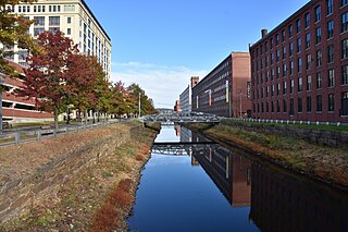
The North Canal Historic District of Lawrence, Massachusetts, encompasses the historic industrial heart of the city. It is centered on the North Canal and the Great Stone Dam, which provided the waterpower for its many mill complexes. The canal was listed on the National Register of Historic Places in 1975, while the district was first listed in 1984, and then expanded slightly in 2009.

The Tavern Acres Historic District encompasses a residential development known as Tavern Acres, which was built in the 1920s with a landscape design by Henry Vincent Hubbard, then with the Olmsted Brothers landscape design firm. It is bounded by Bradstreet Rd., Green and Main Sts. and Park Way in North Andover, Massachusetts. The district encompasses Memorial Park, the Stevens Library, and properties facing Memorial Park and further along Bradstreet Road. The district was listed on the National Register of Historic Places in 1995.
The Spring Hill Historic District is a historic district roughly bounded by Summer, Central, Atherton, and Spring Streets in the Spring Hill area of Somerville, Massachusetts. The district encompasses the city's best-preserved residential subdivision from the mid-19th century, with later infill construction in the late 19th and early 20th centuries. The district was listed on the National Register of Historic Places in 1989.
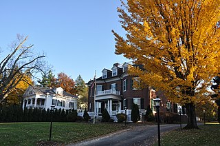
The Andover Street Historic District is a linear residential historic district in the Belvidere neighborhood of eastern Lowell, Massachusetts. The district encompasses large, fashionable houses and estates that were built between the 1860s and the 1930s. It includes properties at 245—834 Andover Street, and at 569 and 579 East Merrimack Street. The district was listed on the National Register of Historic Places in 2000.
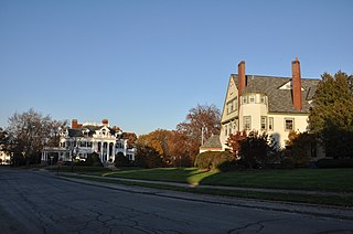
The Belvidere Hill Historic District encompasses a residential area on the east side of Lowell, Massachusetts known for its fine 19th-century houses. The area, roughly bounded by Wyman, Belmont, Fairview, and Nesmith Streets, was developed beginning in the 1850s, and was one of the finest neighborhoods in the city, home to many of its business and civic leaders. It was listed on the National Register of Historic Places in 1995.
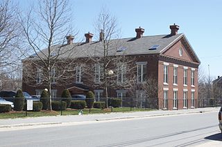
The Colburn School is a historic former school building at 136 Lawrence Street in Lowell, Massachusetts, USA. Built in 1848, it is a fine example of institutional Greek Revival architecture, and is one of the city's older surviving school buildings, built during the rapid population growth that followed the city's industrialization. Now converted to apartments, it was listed on the National Register of Historic Places in 1995.

The Flagg-Coburn House is a historic house at 722 E. Merrimack Street in Lowell, Massachusetts. Built in 1926 for a local industrialist, it is the first known example in New England of the distinctive residential work of New York City architect Ernest Flagg. It was listed on the National Register of Historic Places in 1986.

The Hoyt-Shedd Estate is a historic residential estate at 386-396 Andover Street and 569-579 East Merrimack Street in Lowell, Massachusetts. The houses at 386 and 396 Andover Street are large Stick style mansions, built about the same time and designed by the same architect. They were built for the friends and business partners E. W. Hoyt and F. B. Shedd. Together they made a fortune selling perfume and related products.

The Merrimack Valley is a bi-state region along the Merrimack River in the U.S. states of New Hampshire and Massachusetts. The Merrimack is one of the larger waterways in New England and has helped to define the livelihood and culture of those living along it for millennia.


