
Capitol Hill is a neighborhood in Washington, D.C., located in both Northeast D.C. and Southeast D.C.. Bounded by 14th Street SE & NE, F Street NE, Southeast Boulevard SE, South Capitol Street SE. Dominated by the United States Capitol, which sits on the highest point of Capitol Hill, it is one of the oldest historic districts in Washington. Home to around 35,000 people in just under 2 square miles (5 km2), Capitol Hill is also one of the most densely populated neighborhoods in Washington, D.C.. The name "Capitol Hill" is frequently used as a metonym for the U.S. Congress.

The West Newton Village Center Historic District encompasses the heart of the village of West Newton, in the city of Newton, Massachusetts in the United States. It extends along Washington Street between Lucas Court in the west and Davis Court in the east, and includes a few properties on immediately adjacent side streets, including Watertown Street and Waltham Street. The village is the second-largest of Newton's commercial centers and is the best-preserved of its late 19th and early 20th century village centers. The district was listed on the National Register of Historic Places in 1990.

The Salem–Auburn Streets Historic District is a residential historic district at Salem and Auburn Streets in Cambridge, Massachusetts. The district includes a collection of houses that is among the oldest in the Cambridgeport section of the city, and includes most of the houses on two blocks of these streets. The district was added to the National Register of Historic Places in 1982.

The South Washington Street Historic District is a historic district encompassing 200 years of residential architecture in North Attleborough, Massachusetts. It extends along South Washington Street in the central portion of the town, between Elm Street in the north, and Sutherland Street in the south and includes two properties on Hunking Street. The district was added to the National Register of Historic Places in 1995.

The South Lee Historic District encompasses the historic portion of the village of South Lee in Lee, Massachusetts. Extending mainly along Massachusetts Route 102 between Fairview Street and the Stockbridge town line, the village is a well-preserved 19th-century mill village, with fine Federal and Greek Revival buildings and a later 19th-century paper mill. It was listed on the National Register of Historic Places in 1999.

The Hatfield Center Historic District encompasses the traditional center of Hatfield, Massachusetts. The area, first laid out in 1661, is bounded by Maple Street to the south, the Connecticut River to the east, Day Avenue and School Street to the north, and the Mill River to the west. The area's layout and land use patterns are relatively little altered since they were laid out, leaving a well-preserved early colonial village landscape. The district was added to the National Register of Historic Places in 1994.

The Bradford Common Historic District is a historic district encompassing the former town center of Bradford, now a village of Haverhill, Massachusetts. Centered on the former town common at South Main and Salem Streets, the area served as Bradford's civic and commercial center from about 1750 until its annexation by Haverhill in 1897, and retains architecture from the 18th to early 20th centuries. It was added to the National Register of Historic Places in 1977.

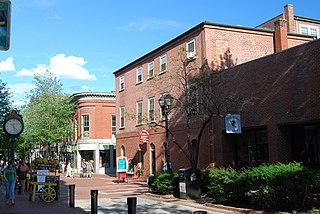
The Chestnut Street District is a historic district bounded roughly by Bridge, Lynn, Beckford, and River Streets in Salem, Massachusetts. It was added to the National Register of Historic Places in 1973 and enlarged slightly in 1978. The district contains a number of architecturally significant works of Samuel McIntire, a builder and woodworker who had a house and workshop at 31 Summer Street, and who designed and built a number of these houses, and others that display the profits made in the Old China Trade by Salem's merchants. The district is a subset of a larger locally designated McIntire Historic District.
Downtown Salem District is a historic district roughly bounded by Church, Central, New Derby, and Washington Streets in Salem, Massachusetts. It was added to the National Register of Historic Places in 1983, and represents a major expansion of the Old Town Hall Historic District, which was listed in 1972.

The Essex Institute Historic District is a historic district at 134-132, 128, 126 Essex Street and 13 Washington Square West in Salem, Massachusetts. It consists of a compact group of properties associated with the Essex Institute, founded in 1848 and merged in 1992 into the Peabody Essex Museum. Listed by increasing street number, they are: the Crowninshield-Bentley House, the Gardner-Pingree House, the John Tucker Daland House, and the Phillips Library. The John Ward House, which fronts on Brown Street but shares the 132 Essex Street address, is another National Historic Landmark within the district. The Andrew Safford House at 13 Washington Square West, built in 1819, was said to be the most expensive home in New England at the time.

The Peabody Civic Center Historic District encompasses a well-preserved portion of the historic center of Peabody, Massachusetts. Extending along Chestnut and Franklin Streets south of Peabody City Hall, the district includes a small residential area built in the mid-19th century, as well as the city hall and St. JOhn the Baptist Roman Catholic Church, two monumental structures defining the town's civic heart. The district was added to the National Register of Historic Places in 1980.

Salem Common Historic District is a historic district bounded roughly by Bridge, Derby, and St. Peter's streets, as well as Collins Cove in Salem, Massachusetts, United States.

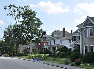
The High Street Historic District in Wilmington, Massachusetts is a residential historic district along High Street. The district runs east from High Street's junction with Salem Street to a sharp bend in the road where it meets the right-of-way for Interstate 93. Of the 17 contributing properties, all but four are located on the north side of the road ; the rest are on the south side. It represents a cluster of high quality houses built mainly in the second half of the 19th century, although there is one contributing property built in 1942. The styling of these houses is diverse, with all of the popular revival styles of the period represented. Houses built in the 20th century are predominantly Colonial Revival or Craftsman/Bungalow in style.
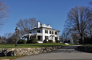
Beebe Homestead, also known as the Lucius Beebe House and Beebe Farm, is a historic Federal period home at 142 Main Street in Wakefield, Massachusetts, which was built during the federal era that extended from the late 18th-century into the 1820s. It is suspected to have been remodeled into the federal style from an earlier home built in circa 1727. It overlooks Lake Quannapowitt, and according to a 1989 study of historic sites in Wakefield, the house is "one of Wakefield's most imposing landmarks." The property was added to the National Register of Historic Places in 1989.
The Lyman Street Historic District is a historic district roughly encompassing Lyman Street between Church and Main Streets in Waltham, Massachusetts. Lyman Street was laid out in 1826 by Theodore Lyman, owner of The Vale, a country estate just to the north. Residential development took place along the street roughly between 1840 and 1900, resulting in a series of fashionable houses in a variety of 19th century architectural styles on the west side of the street. The district was listed on the National Register of Historic Places in 1989.
This is a timeline of the history of the city of Salem, Massachusetts, United States.

The Longwood Historic District is roughly bounded by Chapel, St. Marys, Monmouth, and Kent Sts. in Brookline, Massachusetts. The area was developed in the mid-19th century by David Sears and Amos Adams Lawrence as a fashionable residential area, and retains a number of architecturally distinguished buildings, including the Longwood Towers complex at 20 Chapel Street, Christ's Church Longwood, and Church of Our Saviour, Brookline. The district was listed on the National Register of Historic Places on September 13, 1978.

The Main Street–College Street Historic District encompasses a historically fashionable residential area of Burlington, Vermont. Principally located along Main and College Streets between South Winooski and South Williams Streets, the area was one of the city's most exclusive residential areas from the early 19th century to the early 20th century, and includes a diversity of high quality architecture from that period. It was listed on the National Register of Historic Places in 1988.

The Cove Street Historic District encompasses a small 19th-century neighborhood area of Duxbury, Massachusetts. Located along Cove Street north of the town center, it was developed in the early 19th century to provide housing for workers in nearby shipyards. The architecture of the district includes a variety of single-family housing styles common to the region and time period. The district was added to the National Register of Historic Places in 2019.
The Ascension-Caproni Historic District encompasses a mixed collection of late 19th and early 20th century architecture along Washington, Newcomb, and Thorndike Streets in the Roxbury neighborhood of Boston, Massachusetts. Including religious, residential, commercial, and industrial buildings, it encapsulates the area's transition from industrial to residential uses between about 1850 and 1930. The district was listed on the National Register of Historic Places in 2019.


