Wavrille | |
|---|---|
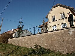 The town hall in Wavrille | |
 Location of Wavrille | |
 Wavrille  Wavrille | |
| Coordinates: 49°19′42″N5°23′24″E / 49.3283°N 5.39°E | |
| Country | France |
| Region | Grand Est |
| Department | Meuse |
| Arrondissement | Verdun |
| Canton | Montmédy |
| Intercommunality | Damvillers Spincourt |
| Government | |
| • Mayor (2020–2026) | Ernest Furina [1] |
Area 1 | 5.31 km2 (2.05 sq mi) |
| Population (2023) [2] | 47 |
| • Density | 8.9/km2 (23/sq mi) |
| Time zone | UTC+01:00 (CET) |
| • Summer (DST) | UTC+02:00 (CEST) |
| INSEE/Postal code | 55580 /55150 |
| Elevation | 210–361 m (689–1,184 ft) (avg. 228 m or 748 ft) |
| 1 French Land Register data, which excludes lakes, ponds, glaciers > 1 km2 (0.386 sq mi or 247 acres) and river estuaries. | |
Wavrille is a commune in the Meuse department in Grand Est in north-eastern France.