
Cochituate is a census-designated place (CDP) in the town of Wayland in Middlesex County, Massachusetts, United States. The population was 6,927 at the 2020 census, out of 13,943 in the entire town of Wayland.

Chestnut Hill is a wealthy New England village located six miles (10 km) west of downtown Boston, Massachusetts, United States. It is best known for being home to Boston College and a section of the Boston Marathon route. Like all Massachusetts villages, Chestnut Hill is not an incorporated municipal entity. It is located partially in Brookline in Norfolk County; partially in the city of Boston in Suffolk County, and partially in the city of Newton in Middlesex County. Chestnut Hill's borders are defined by the 02467 ZIP Code. The name refers to several small hills that overlook the 135-acre Chestnut Hill Reservoir rather than one particular hill.

The Cochituate Aqueduct was an aqueduct in Massachusetts that brought water to Boston from 1848 to 1951.
This is a list of historic sites in Framingham, Massachusetts. There are several notable historic sites in Framingham, according to the Framingham Historical Society. This local society asserts:
While there are many historic spaces in Framingham, the Centre Common is the focal point for the town's past. Three of the town's most historic buildings on the Centre Common face "demolition by neglect." The Village Hall, the Edgell Memorial Library, and the Old Academy building not only house over 10,000 artifacts spanning four centuries of the town's history, but they are symbols of Framingham's commitment to educational excellence, civic engagement, and community pride.

The Old Connecticut Path was the Native American trail that led westward from the area of Massachusetts Bay to the Connecticut River Valley, the first of the North American trails that led west from the settlements close to the Atlantic seacoast, towards the interior. The earliest colonists of Massachusetts Bay Colony used it, and rendered it wider by driving cattle along it. The old route is still followed, for part of its length, by Massachusetts Route 9 and Massachusetts Route 126.
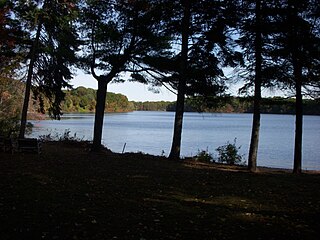
Lake Cochituate is a body of water in Natick, Wayland, and Framingham, Massachusetts, United States. Originally a reservoir serving Boston, it no longer serves that function, and is now a local recreational resource and home to Cochituate State Park.

Becket Center Historic District is a historic district encompassing the historic early center of Becket, Massachusetts. Centered at the junction of Massachusetts Route 8 and YMCA Road, this area was the town's civic heart and a center of industry until it was eclipsed in importance by North Becket, which was served by the railroad. Most of the architecture in the district is in the Federal and Greek Revival styles popular in the late 18th to mid 19th centuries. The district was added to the National Register of Historic Places in 1982.

The South Egremont Village Historic District encompasses most of the village of South Egremont, Massachusetts, a well-preserved village whose architecture has seen relatively little alteration since the 1840s. It is located along Massachusetts Route 23 in the plains east of the Taconic Mountains. The district was listed on the National Register of Historic Places in 1984.

The Heath Center Historic District encompasses a rural village with predominantly 18th- and 19th-century structures in Heath, a small agricultural town in hills of northwestern Franklin County, Massachusetts, United States. The district is centered on the junction of several roads, around which the center of the town grew. South Road arrives from the south, East Main Street and Bray Road from the east, Ledge Road from the north, and West Main Street from the west.

The Wendell Town Common Historic District encompasses the historic heart of the small town of Wendell, Massachusetts. Centered on a town common established in 1782, it includes a significant number of well preserved Greek Revival buildings. The district was listed on the National Register of Historic Places in 1992.

The Granville Center Historic District is a historic district encompassing the historic center of Granville, Massachusetts. The cluster of buildings in the village center includes the Congregational church, and a number of Federal and Greek Revival residences. The district was listed on the National Register of Historic Places in 1991.

The Sudbury Center Historic District is a historic district on Concord and Old Sudbury Roads in Sudbury, Massachusetts. It was listed on the National Register of Historic Places in 1976. In 1976, it included 80 buildings over 193.6 acres (0.783 km2).

The Dorchester Community Church is a historic church building off NH 118 in Dorchester, New Hampshire. Built in 1828 and rebuilt on a smaller scale in 1883, it is a well-preserved local example of Greek Revival architecture. The church was listed on the National Register of Historic Places in 1980, and included in the Dorchester Common Historic District in 1985.

The Middlefield Center Historic District encompasses the historic village center of Middlefield, Massachusetts. It is centered on the junction of Skyline Trail, the main north-south road, with Bell and Town Hill Roads. The district was listed on the National Register of Historic Places in 2012.

Benson Village is the village center of the rural town of Benson, Vermont. The central portion of the village, stretching along Stage Road from Lake Road to Hulett Hill Road, is a historic district listed on the National Register of Historic Places as a well-preserved 19th-century village center.

The Wallingford Main Street Historic District encompasses the historic portions of the village of Wallingford, Vermont. An essentially linear district extending along Main Street on either side of School Street, it has a well-preserved array of 19th and early-20th century residential, commercial, and civic buildings. It was listed on the National Register of Historic Places in 1984.

The Strafford Village Historic District encompasses the historic village center of Strafford, Vermont, United States. Founded in 1768, the village center was developed in the 1790s, and saw most of its growth before 1840, resulting in a fine assortment of predominantly Greek Revival buildings. Notable exceptions include the 1799 meetinghouse, and the Justin Smith Morrill Homestead, a fine example of Gothic Revival architecture built by native son Justin Smith Morrill. The district, centered on the town green at the junction of Morrill Highway and Brook Road, was listed on the National Register of Historic Places in 1974.

The Thetford Hill Historic District encompasses the well-preserved 19th-century village center of Thetford Hill in Thetford, Vermont. Developed between 1792 and about 1860 and located at what is now the junction of Vermont Route 113 and Academy Road, it includes mainly residential buildings, as well as several buildings of Thetford Academy and the 1785-88 Thetford Meetinghouse, one of the state's oldest churches in continuous use. The district was listed on the National Register of Historic Places in 1988.

The Watertown Center Historic District encompasses the historic village center of Watertown, Connecticut. It exhibits architectural and historic changes from the early 1700s into the 20th century. It is roughly bounded by Main, Warren, North, Woodbury, Woodruff, and Academy Hill Roads, and was listed on the National Register of Historic Places in 2001.

First Parish of Sudbury refers to both an historic meetinghouse and a Unitarian Universalist congregation in Sudbury, Massachusetts, United States. The meetinghouse was built in 1797 on the site of the first meetinghouse built on the west side on the Sudbury River. The meetinghouse was designed by Captain Thomson and built at a cost of $6,025.93. It was paid for by the Town of Sudbury to be the meetinghouse for both Town Meetings and parish worship.


