
Ellington Airport is a public and military use airport in Harris County, Texas, United States. It is owned by the City of Houston's department of aviation, Houston Airport System and located 15 nmi southeast of downtown Houston. Formerly known as Ellington Field, then Ellington Air Force Base, then again as Ellington Field it is included in the National Plan of Integrated Airport Systems for 2011–2015, which categorized it as a general aviation reliever airport. The airport does not have scheduled commercial passenger service. However, Continental Airlines used to operate daily regional services between Ellington and Houston's George Bush Intercontinental Airport between 1990 and 2004. On 17 October 2018, the City of Houston approved Phase 1 of the Houston Spaceport project on the Ellington Airport site.

Lubbock Preston Smith International Airport is five miles north of Lubbock, in Lubbock County, Texas, United States. Originally Lubbock International Airport, it was renamed in 2004 for former Texas governor Preston E. Smith, an alumnus of Texas Tech University.
Greater Binghamton Airport is a county-owned American airport eight miles north of Binghamton, in Broome County, New York. It is in East Maine, New York and serves the Southern Tier of New York.

Montgomery Regional Airport is a civil-military airport seven miles southwest of Montgomery, the capital of Alabama. Owned by the Montgomery Airport Authority, it is used for general aviation and military aviation, and sees two airlines.
Del Rio International Airport is two miles northwest of Del Rio, in Val Verde County, Texas, United States. It is used for general aviation, and, being near Laughlin Air Force Base, it is often used by USAF students during training flights.

West Michigan Regional Airport, formerly Tulip City Airport, is a public-use airport located two nautical miles (3.7 km) south of the central business district of Holland, a city in Ottawa County and Allegan County, Michigan, United States. It is included in the Federal Aviation Administration (FAA) National Plan of Integrated Airport Systems for 2017–2021, in which it is categorized as a national general aviation facility.
Beaumont Municipal Airport is seven miles west of downtown Beaumont, in Jefferson County, Texas. The National Plan of Integrated Airport Systems for 2017–2021 categorized it as a general aviation facility.
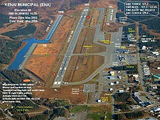
Kenai Municipal Airport is a city-owned, public-use airport located in Kenai, a city in the Kenai Peninsula Borough of the U.S. state of Alaska.

Charlevoix Municipal Airport is a city-owned, public-use airport located one nautical mile (2 km) southwest of the central business district of Charlevoix, a city in Charlevoix County, Michigan, United States. It is mostly used for general aviation, but also offers passenger service to Beaver Island via Island Airways and Fresh Air Aviation.
Iowa City Municipal Airport, is two miles southwest of downtown Iowa City, in Johnson County, Iowa. It is the oldest civil airport west of the Mississippi River still in its original location.

Kenosha Regional Airport is a city-owned public-use airport located four nautical miles (7 km) west of the central business district of Kenosha, a city in Kenosha County, Wisconsin, United States.
Skylark Field is a city-owned, public-use airport located three nautical miles (6 km) east of the central business district of Killeen, a city in Bell County, Texas, United States. It is included in the National Plan of Integrated Airport Systems for 2011–2015, which categorized it as a general aviation facility. It was formerly known as Killeen Municipal Airport.

Felts Field is a public airport in the northwest United States, located five miles (8 km) northeast of downtown Spokane, in Spokane County, Washington. It is owned by Spokane City-County.

Steamboat Springs Airport is a city-owned airport three miles northwest of Steamboat Springs, in Routt County, Colorado. The National Plan of Integrated Airport Systems for 2011–2015 categorized it as a general aviation facility.
Brewton Municipal Airport is a city-owned public-use airport located 3 nautical miles (6 km) south of the central business district of Brewton, a city in Escambia County, Alabama, United States. Originally constructed by the U.S. Navy during World War II as an auxiliary field to the Naval Air Station Pensacola complex, it was later redesignated as Navy Outlying Landing Field (NOLF) Brewton before being conveyed to the city of Brewton as a public use facility. Although under civilian ownership, the airfield still functions concurrently as NOLF Brewton and is used by Navy training aircraft located at Naval Air Station Whiting Field, Florida.
St. Paul Island Airport is a state-owned, public-use airport located on St. Paul Island in the Aleutians West Census Area of the U.S. state of Alaska. It is situated near the city of St. Paul, the island's main settlement. Scheduled airline service to Anchorage International Airport is provided by Ravn Alaska.
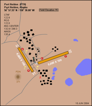
Port Heiden Airport is a state-owned public-use airport located six nautical miles northeast of the central business district of Port Heiden, in the Lake and Peninsula Borough of the U.S. state of Alaska. Scheduled airline service to King Salmon Airport is provided by Peninsula Airways (PenAir).
New Stuyahok Airport is a state-owned, public-use airport located one nautical mile (1.85 km) west of the central business district of New Stuyahok, a city in the Dillingham Census Area of the U.S. state of Alaska. Scheduled airline service to Dillingham Airport is provided by Peninsula Airways (PenAir).
Richmond Municipal Airport is six miles southeast of Richmond near Boston, in Wayne County, Indiana. It is owned by the Richmond Board of Aviation Commissioners. The National Plan of Integrated Airport Systems for 2011–2015 called it a general aviation facility.
Polson Airport is a public use airport in Lake County, Montana, United States. It is located one nautical mile (2 km) west of the central business district of Polson, a city on the southern shore of Flathead Lake. The airport is owned by the City of Polson and Lake County. It is included in the National Plan of Integrated Airport Systems for 2011–2015, which categorized it as a general aviation facility.


