
The Westgate Hotel is a Grade II listed hotel in Newport city centre, whose name and site is famous as the scene of the 1839 Chartist riot, also called the Newport Rising. It is located at the bottom of Stow Hill.
Cameo is an American soul-influenced funk group that formed in the early 1970s. Cameo was initially a 14-member group known as the New York City Players; this name was later changed to Cameo to avoid being confused with Ohio Players, another funk group in the 1970s.

Westgate-on-Sea is a seaside town and civil parish in northeast Kent, England, with a population of 6,996 at the 2011 Census. It is within the Thanet local government district and borders the larger seaside resort of Margate. Its two sandy beaches have remained a popular tourist attraction since the town's development in the 1860s from a small farming community.

Wakefield Westgate railway station is a mainline railway station in Wakefield, West Yorkshire, England. It is 10 miles (16 km) south of Leeds to the west of the city centre, on the Wakefield Line and Leeds branch of the East Coast Main Line.

Westgate-on-Sea railway station is on the Chatham Main Line in England, serving the town of Westgate-on-Sea, Kent. It is 72 miles 35 chains (116.6 km) down the line from London Victoria and is situated between Birchington-on-Sea and Margate.
Westgate Resorts is an American timeshare resort company founded by David A. Siegel in 1982.
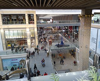
The Westgate Centre is a major shopping centre in Oxford city centre, England, that was extensively remodelled and extended between 2016–17. The original centre was built between 1970–72, designed by Douglas Murray and built by Taylor Woodrow. The centre was closed in February 2016 for comprehensive redevelopment, and reopened on Tuesday 24 October 2017.

Westgate is a community within the Hilltop area of Columbus, Ohio. It was partially constructed on land that formerly housed the American Civil War Camp Chase and a Confederate prison. After the Civil War, the land was purchased by Joseph Binns and his associates with the intent to start a Quaker community. These plans failed to materialize and the land was developed as a "streetcar suburb" in the 1920s. Located 4 miles (6.4 km) west of downtown, the neighborhood is home to Westgate Park and Recreation Center, Westgate Alternative Elementary School, St. Mary Magdalene Church and school, and Parkview United Methodist Church. 4,500 residents live within the Westgate boundaries, most in single family houses.
Westgate Center is a 640,000 sq ft (59,000 m2) regional shopping center located in the West San Jose neighborhood of San Jose, California. The mall is located at the intersection of Saratoga Avenue and Campbell Avenue.

'Westgate Football Club' also referred to as Westgate Sindjelic, is a semi-professional Serbian-founded Australian football club located in Ardeer, Melbourne, that plays in the Victorian State League Division 2, Australia's joint fifth tier in the country's league system.

Westgate is a residential neighbourhood in the southwest quadrant of Calgary, Alberta. It is bounded by Bow Trail to the north, 45 Street W to the east, 17 Avenue S to the south and Sarcee Trail to the west. Edworthy Park is located north of the community.

Neverwinter Nights 2: Mysteries of Westgate (NWN2:MoW) is an expansion pack for the role-playing video game Neverwinter Nights 2. It was developed by Ossian Studios and published by Atari on April 29, 2009. The player creates a character and controls it, along with a group of three pre-designed companions, journeying through the game world. The gameplay is very similar to that of the base game. Mysteries of Westgate also includes new monsters, music, and other tools, which can be used by players to create their own Neverwinter Nights 2 levels.
Westgate Mall is an indoor community shopping mall in Bethlehem, Pennsylvania. It is located in the Lehigh Valley. It is located near US Route 22 on Schoenersville Road.

Westgate Farms is an unincorporated community in New Castle County, Delaware, United States. Westgate Farms is a small neighborhood located east of Loveville Road between Delaware Route 41 and Delaware Route 48 to the southeast of Hockessin.
Westgate is a neighborhood in Austin, Texas, located southwest of the city's urban core. It includes ZIP code 78745.

Westgate is a neighborhood in the Southwest District of Baltimore, located between Baltimore County (west) and the city neighborhood of Ten Hills (east). Its boundaries are marked by Baltimore National Pike (north), Frederick Avenue (south), Rock Glen Avenue and Edmondson Avenue (east) and the city line (west).

On Saturday, 21 September 2013, four masked gunmen attacked the Westgate shopping mall, an upscale mall in Nairobi, Kenya. There are conflicting reports about the number killed in the attack, since part of the mall collapsed due to a fire that started during the siege. The attack resulted in 71 total deaths, including 62 civilians, five Kenyan soldiers, and four attackers. Approximately 200 people were wounded in the mass shooting.

Westgate is a lifestyle and family shopping mall in Jurong East, Singapore. It is the only mall with direct connections to both Jurong East MRT station and Jurong East Bus Interchange.

66 Westgate Street is a grade II* listed building in Gloucester, UK. It has been listed by Historic England under the Planning Act 1990.

The Westgate Tower is a mixed-use high-rise building in downtown Austin, Texas. The twenty-six-story 261-foot (80 m) tower block was designed in 1962 and completed in 1966; its name reflects its location across the street from the west gate of the Texas State Capitol. Designed by architect Edward Durell Stone, the tower was added to the National Register of Historic Places in 2010 and designated a Recorded Texas Historic Landmark in 2012.


