Weston, Idaho

Last updated

Weston, Idaho
City
Weston idaho.jpg
Franklin County Idaho Incorporated and Unincorporated areas Weston Highlighted 1687040.svg
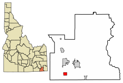
Location of Weston in Franklin County, Idaho.
Coordinates: 42°02′13″N111°58′42″W / 42.03694°N 111.97833°W / 42.03694; -111.97833
Country United States
State Idaho
County Franklin
Area
[1]
  Total
1.90 sq mi (4.93 km2)
  Land1.90 sq mi (4.92 km2)
  Water0.01 sq mi (0.01 km2)
Elevation
[2]
4,741 ft (1,445 m)
Population
 (2020) [3]
  Total
511
  Density247.37/sq mi (95.50/km2)
Time zone UTC-7 (Mountain (MST))
  Summer (DST) UTC-6 (MDT)
ZIP code
83286
Area code 208
FIPS code 16-87040
GNIS feature ID2412240 [2]

Weston is a city in Franklin County, Idaho, United States. The population was 511 at the 2020 census. It is part of the Logan, Utah-Idaho Metropolitan Statistical Area. It was first settled in 1865. [4] The community was so named due to its location at the west bank of the Bear River. [5]

Contents

Geography

According to the United States Census Bureau, the city has a total area of 1.98 square miles (5.13 km2), of which, 1.97 square miles (5.10 km2) is land and 0.01 square miles (0.03 km2) is water. [6]

Demographics

Historical population
CensusPop.Note
1910 308
1920 45246.8%
1930 429−5.1%
1940 4392.3%
1950 382−13.0%
1960 284−25.7%
1970 230−19.0%
1980 31034.8%
1990 39025.8%
2000 4259.0%
2010 4372.8%
2020 51116.9%
U.S. Decennial Census [7]

2010 census

As of the census [3] of 2010, there were 437 people, 139 households, and 112 families residing in the city. The population density was 221.8 inhabitants per square mile (85.6/km2). There were 147 housing units at an average density of 74.6 per square mile (28.8/km2). The racial makeup of the city was 98.4% White, 0.5% African American, and 1.1% from two or more races. Hispanic or Latino of any race were 0.5% of the population.

There were 139 households, of which 45.3% had children under the age of 18 living with them, 74.1% were married couples living together, 4.3% had a female householder with no husband present, 2.2% had a male householder with no wife present, and 19.4% were non-families. 18.7% of all households were made up of individuals, and 7.2% had someone living alone who was 65 years of age or older. The average household size was 3.14 and the average family size was 3.63.

The median age in the city was 29 years. 37.1% of residents were under the age of 18; 6.6% were between the ages of 18 and 24; 22.2% were from 25 to 44; 24.9% were from 45 to 64; and 9.2% were 65 years of age or older. The gender makeup of the city was 49.9% male and 50.1% female.

2000 census

As of the census [8] of 2000, there were 425 people, 118 households, and 105 families residing in the city. The population density was 214.6 inhabitants per square mile (82.9/km2). There were 129 housing units at an average density of 65.1 per square mile (25.1/km2). The racial makeup of the city was 97.18% White, 0.24% Pacific Islander, 1.88% from other races, and 0.71% from two or more races. Hispanic or Latino of any race were 3.29% of the population.

There were 118 households, out of which 56.8% had children under the age of 18 living with them, 81.4% were married couples living together, 5.1% had a female householder with no husband present, and 11.0% were non-families. 11.0% of all households were made up of individuals, and 4.2% had someone living alone who was 65 years of age or older. The average household size was 3.60 and the average family size was 3.84.

In the city, the population was spread out, with 39.5% under the age of 18, 9.9% from 18 to 24, 24.9% from 25 to 44, 17.9% from 45 to 64, and 7.8% who were 65 years of age or older. The median age was 25 years. For every 100 females, there were 103.3 males. For every 100 females aged 18 and over, there were 107.3 males.

The median income for a household in the city was $35,556, and the median income for a family was $35,750. Males had a median income of $31,458 versus $17,188 for females. The per capita income for the city was $10,206. About 8.6% of families and 11.0% of the population were below the poverty line, including 11.8% of those under age 18 and 12.9% of those age 65 or over.

Notable people

Related Research Articles

<span class="mw-page-title-main">Downey, Idaho</span> City in Bannock County, Idaho, United States

Downey is a city in the Marsh Valley in southern Bannock County, Idaho, United States. It is part of the Pocatello Metropolitan Statistical Area. The population was 571 at the 2020 census.

<span class="mw-page-title-main">McCammon, Idaho</span> City in Idaho, United States

McCammon is a city in Bannock County, Idaho, United States. It is part of the Pocatello, Idaho Metropolitan Statistical Area'. The population was 825 at the 2020 census. In 1892, McCammon became the junction point between the Oregon Short Line Railroad and Utah and Northern Railway, and city gained the nickname Junction City.

<span class="mw-page-title-main">Paris, Idaho</span> City in Idaho, United States

Paris is a city and county seat of Bear Lake County, Idaho, United States. Located on the western side of the Bear Lake Valley, the city's population was 541 at the 2020 census. Paris was settled on September 26, 1863, by pioneer settlers of the Church of Jesus Christ of Latter-day Saints.

<span class="mw-page-title-main">St. Charles, Idaho</span> City in Idaho, United States

St. Charles or Saint Charles is a city in southern Bear Lake County, Idaho, United States, that is located near the northwestern shore of Bear Lake. Its population was 131 at the 2010 census, down from 156 in 2000.

<span class="mw-page-title-main">Aberdeen, Idaho</span> City in Bingham County, Idaho, United States

Aberdeen is a city in Bingham County, Idaho, United States. The community was named after Aberdeen, in Scotland. The population was 1,756 at the 2020 census.

<span class="mw-page-title-main">Basalt, Idaho</span> City in Bingham County, Idaho, United States

Basalt is a city in Bingham County, Idaho, United States. The population was 394 at the 2010 census.

<span class="mw-page-title-main">Wilder, Idaho</span> City in Idaho, United States

Wilder is a city in Canyon County, Idaho, United States. The population was 1,533 at the 2010 census.

<span class="mw-page-title-main">Bancroft, Idaho</span> City in Caribou County, Idaho, United States

Bancroft is a city in the Gem Valley in Caribou County, Idaho, United States. The population was 299 at the 2020 census, and 377 at the 2010 census.

<span class="mw-page-title-main">Albion, Idaho</span> City in Idaho, United States

Albion is a city in Cassia County, Idaho, United States. It is part of the Burley, Idaho Micropolitan Statistical Area. The population was 234 at the 2020 census. Albion was the county seat of Cassia County from 1879 to 1918.

<span class="mw-page-title-main">Clifton, Idaho</span> City in Idaho, United States

Clifton is a city in Franklin County, Idaho, United States. The population was 413 at the 2020 census. It is part of the Logan, Utah-Idaho Metropolitan Statistical Area.

<span class="mw-page-title-main">Dayton, Idaho</span> City in Idaho, United States

Dayton is a city in Franklin County, Idaho, United States. The population was 510 at the 2020 census. It is part of the Logan, Utah-Idaho Metropolitan Statistical Area.

<span class="mw-page-title-main">Franklin, Idaho</span> City in Idaho, United States

Franklin is a city in Franklin County, Idaho, United States. The population was 1,025 at the 2020 census. It is part of the Logan, Utah-Idaho Metropolitan Statistical Area.

<span class="mw-page-title-main">Preston, Idaho</span> City in Idaho, United States

Preston is a city in Franklin County, Idaho, United States. The population was 5,591 at the 2020 census, up from 5,204 at the 2010 census. The city is the county seat of Franklin County. It is part of the Logan, Utah-Idaho Metropolitan Statistical Area.

<span class="mw-page-title-main">Sugar City, Idaho</span> City in Idaho, United States

Sugar City is a city in Madison County, Idaho, United States. The population was 1,715 at the 2020 census, up from 1,514 in 2010. It is part of the Rexburg Micropolitan Statistical Area.

<span class="mw-page-title-main">Heyburn, Idaho</span> City in Idaho, United States

Heyburn is a city in Minidoka County, Idaho, United States. The population was 3,700 at the 2020 census, up from 3,089 in 2010. It is part of the Burley micropolitan area.

<span class="mw-page-title-main">Cache, Utah</span> CDP in Utah, United States

Cache Junction is a census-designated place (CDP) in Cache County, Utah, United States. The population was 38 at the 2010 census. It is included in the Logan, Utah-Idaho (partial) Metropolitan Statistical Area.

<span class="mw-page-title-main">Cornish, Utah</span> Town in the state of Utah, United States

Cornish is a town in Cache County, Utah, United States. The population was 274 at the 2020 census. It is included in the Logan, Utah-Idaho (partial) Metropolitan Statistical Area.

<span class="mw-page-title-main">Lewiston, Utah</span> City in Utah, United States

Lewiston is a city in Cache County, Utah, United States. It is situated at the northern Utah border and borders the state of Idaho. The population was 1,939 at the 2020 census. It is included in the Logan, Utah-Idaho (partial) Metropolitan Statistical Area.

<span class="mw-page-title-main">River Heights, Utah</span> City in Utah, United States

River Heights is a city in Cache County, Utah, United States. The population was 2,144 at the 2020 census. It is included in the Logan, Utah-Idaho (partial) Metropolitan Statistical Area.

<span class="mw-page-title-main">Trenton, Utah</span> Town in Utah, United States

Trenton is a town in Cache County, Utah, United States. The population was 512 at the 2020 census. It is included in the Logan, Utah-Idaho (partial) Metropolitan Statistical Area.

References

  1. "2019 U.S. Gazetteer Files". United States Census Bureau. Retrieved July 9, 2020.
  2. 1 2 U.S. Geological Survey Geographic Names Information System: Weston, Idaho
  3. 1 2 "U.S. Census website". United States Census Bureau . Retrieved December 18, 2012.
  4. Leonard J. Arrington. History of Idaho. Vol. 1, p. 275
  5. Lund, Anthon Henrik (1922). The Utah Genealogical and Historical Magazine. Geneal. Society of Utah. p. 41.
  6. "US Gazetteer files 2010". United States Census Bureau . Retrieved December 18, 2012.
  7. "Census of Population and Housing". Census.gov. Retrieved June 4, 2015.
  8. "U.S. Census website". United States Census Bureau . Retrieved January 31, 2008.