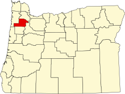
Whiteson | |
---|---|
Coordinates: 45°09′05″N123°11′48″W / 45.15139°N 123.19667°W | |
Country | United States |
State | Oregon |
County | Yamhill |
Elevation | 164 ft (50 m) |
Time zone | UTC-8 (Pacific (PST)) |
• Summer (DST) | UTC-7 (PDT) |
GNIS feature ID | 1166722 [1] |
Whiteson is an unincorporated community in Yamhill County, Oregon, United States. Oregon Geographic Names states that Whiteson is named for either for Henry White, who laid out the town site and gave the railroad right-of-way, or for William White. It is possible they are members of the same family. Whiteson post office was established in 1890. Whiteson is an agricultural community lacking either Oregon hamlet or village classification, and relies on the neighboring communities of McMinnville and Amity for basic services such as fire, health, and education. [2] The Yamhill County Sheriff has primary police jurisdiction over Whiteson. [2]
Whiteson is located 3 miles south of McMinnville, on Oregon Route 99W, near Whiteson Dip Bridge.
This region experiences warm (but not hot) and dry summers, with no average monthly temperatures above 71.6 °F. According to the Köppen Climate Classification system, Whiteson has a warm-summer Mediterranean climate, abbreviated "Csb" on climate maps. [3]
Whiteson School District 78 was established in 1892, and the first one-room schoolhouse was finished in the March 1893. In 1903 the decision was made to create an addition to the Whiteson school, making it a two-room school. 1936 was the last year school was taught here, before the district finally consolidated with Amity School District 4, in 1942. [4]
Whiteson railway station is the railway station, where the Dayton, Sheridan and Grande Ronde Railroad crossed the west side line of the Oregon and California Railroad.
Whiteson was formerly a notable station along the Red Electric interurban network. Initial service extended from Portland to Whiteson, but eventually reached Corvallis in 1917. By 1920, the schedule had four daily trains through from Portland to Corvallis in each direction and two more that ran as far as Whiteson. [5] [6]
Yamhill County is one of the 36 counties in the U.S. state of Oregon. As of the 2020 census, the population was 107,722. The county seat is McMinnville. Yamhill County was named after the Yamhelas, members of the Kalapuya Tribe.
Forest Grove is a city in Washington County, Oregon, United States, 25 miles (40 km) west of Portland. Originally a small farm town, it is now primarily a commuter town in the Portland metro area. Settled in the 1840s, the town was platted in 1850, then incorporated in 1872, making it the first city in Washington County. The population was 21,083 at the 2010 census, an increase of 19.1% over the 2000 figure (17,708).
Gaston is a city in Washington County, Oregon, United States. Located between Forest Grove to the north and Yamhill to the south, the city straddles Oregon Route 47 and borders the Tualatin River. Named after railroad executive Joseph Gaston, its population was 637 as of the 2010 census.
Carlton is a city in Yamhill County, Oregon, United States. The population was 2,135 as of the 2020 Census.
McMinnville is the county seat of and largest city in Yamhill County, Oregon, United States. The city is named after McMinnville, Tennessee. As of the 2020 census, the city had a population of 34,319.
Newberg is a city in Yamhill County, Oregon, United States. Located in the Portland metropolitan area, the city is home to George Fox University. As of the 2020 census, the city population was 25,138 making it the second most populous city in the county.
Sheridan is a city in Yamhill County, Oregon, United States. Platted in the 1860s when it received a post office, the city was incorporated in 1880. A major fire burned much of the city in 1913, and a flood covered much of the city in 1964. The population of the city as of the 2020 Census was 6,100, a decrease from 6,127 at the 2010 census.
Willamina is a city in Polk and Yamhill Counties in the U.S. state of Oregon. The population was 2,239 at the 2020 census.
The Oregon Electric Railway (OE) was an interurban railroad line in the U.S. state of Oregon that linked Portland to Eugene. Service from Portland to Salem began in January 1908. The Spokane, Portland and Seattle Railway purchased the system in 1910, and extended service to Eugene in 1912. Regular passenger service in the Willamette Valley ended in May 1933. Freight operations continued and the railway survived into the 1990s, ultimately as a Burlington Northern feeder. Operation as an electric railroad ended July 10, 1945.
Mount Hood is an unincorporated community and census-designated place (CDP) in Hood River County, Oregon, United States, about 3 miles (5 km) northeast of Parkdale on Oregon Route 35. As of the 2010 census it had a population of 286. Mount Hood is the terminus of Oregon Route 281, the Hood River Highway.
The Portland and Western Railroad is a 516-mile (830 km) Class II railroad serving the U.S. state of Oregon, and is a wholly owned subsidiary of shortline and regional railroad holding company Genesee & Wyoming Inc. The PNWR includes a subsidiary, the Willamette and Pacific Railroad.
Bellevue is an unincorporated rural community in Yamhill County, Oregon, United States. It is named for the French words for "beautiful view". It is not known who named the community, but it was settled in about 1860, and a previous post office in the area was named "Muddy". The community is located on the donation land claim of Hathaway Yocum, who came to Oregon from Illinois in 1851. Bellevue post office operated from 1869 to 1904.
Alvadore is an unincorporated community in Lane County, Oregon, United States, located nine miles northwest of downtown Eugene and one mile northeast of Fern Ridge Reservoir.
The Willamette Valley AVA is an American Viticultural Area which lies in the Willamette Valley of Oregon. The AVA is the wine growing region which encompasses the drainage basin of the Willamette River. It stretches from the Columbia River in the north to just south of Eugene in the south, where the Willamette Valley ends; and from the Oregon Coast Range in the west to the Cascade Mountains in the east. At 5,360 square miles (13,900 km2), it is the largest AVA in the state, and contains most of the state's wineries; approximately 908 as of 2021.
Gardiner is an unincorporated community and census-designated place in Douglas County, Oregon, United States, across the Umpqua River from Reedsport. It is located on U.S. Route 101. As of the 2010 census, it had a population of 248.
Blodgett is a census-designated place (CDP) and unincorporated community in Benton County, Oregon, United States, where Oregon Route 180 meets U.S. Route 20 in the Central Oregon Coast Range 15 miles (24 km) west of Corvallis. It is near the confluence of the Tumtum and Marys rivers. As of the 2010 census, the community had a population of 58.
Marion Forks is an unincorporated community on the North Santiam Highway, 15 miles (24 km) south of the city of Detroit, in Linn County, Oregon, United States.
Saint Joseph is an unincorporated community in Yamhill County, Oregon, United States. It is located about two miles west of Lafayette near Oregon Route 99W. The area is sometimes known as "St. Joe".
Gibbon is an unincorporated community in Umatilla County, Oregon, United States. It is about 20 miles (32 km) east of Pendleton on the Umatilla Indian Reservation, near the Umatilla River.
The Southern Pacific Red Electric Lines, also known simply as the Red Electric, was a network of interurban passenger train services operated by the Southern Pacific Railroad in the Willamette Valley of the U.S. state of Oregon from 1914 to 1929. The service got its name from the bright red color of its cars. Despite its short history, among West Coast interurbans it was unique, and it was considered the finest such system in the Pacific Northwest. It was the only major electric interurban railroad converted from steam to electric passenger use. It was also one of few systems using all-steel equipment, and one of the largest 1500-volt systems in the country.