Fairburn Ings Nature Reserve is a protected area in West Yorkshire, England, noted for its avian biodiversity. The reserve has recorded around 280 bird species, remarkable for an inland site in the United Kingdom. This is explained by the site being on migration routes as well as the diversity of habitats.

Stoke-on-Trent is a city and unitary authority area in Staffordshire, England, with an area of 36 square miles (93 km2). In 2019, the city had an estimated population of 256,375. It is the largest settlement in Staffordshire.
Sandwell Valley Country Park is a country park, run by Sandwell Metropolitan Borough Council, in Sandwell Valley, on the River Tame in the middle of the urban conurbation between Birmingham and West Bromwich in West Midlands, England.

Ingrebourne Valley is a local nature reserve (LNR) in Hornchurch in the London Borough of Havering. It is owned and managed by Havering Council, and has a visitor centre managed by the Essex Wildlife Trust. Most of it is in Hornchurch Country Park west of the River Ingrebourne, but there are also areas north and south of the park which are part of the LNR. It has a wide range of habitats, including woodland, grassland, the river and marshes. It is an important site for a range of species of plants, animals and birds, including great crested newts, slow worms, the harvest mouse and the water vole.

Smallthorne is an area in the city of Stoke-on-Trent in Staffordshire, England. It is in the north-east of the city, near Burslem. Smallthorne borders Bradeley and Chell in the north, Norton-in-the-Moors in the east, Sneyd Green in the south, and Burslem in the west.

Sneyd Green is an area in the city of Stoke-on-Trent in Staffordshire, England. It is in the north-east of the city, approx. 1.5 miles (2.4 km) from Hanley. Sneyd Green borders Smallthorne in the north, Milton in the east, Birches Head in the south, and Cobridge in the west.

Cotwall End Valley is a local nature reserve in West Midlands, England. It is about a mile south of Sedgley, in the Metropolitan Borough of Dudley.

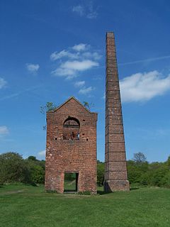
The North Staffordshire Coalfield was a coalfield in Staffordshire, England, with an area of nearly 100 square miles (260 km2), virtually all of it within the city of Stoke on Trent and the borough of Newcastle-under-Lyme, apart from three smaller coalfields, Shaffalong and Goldsitch Moss Coalfields near Leek and the Cheadle Coalfield. Coal mining in North Staffordshire began early in the 13th century, but the industry grew during the Industrial Revolution when coal mined in North Staffordshire was used in the local Potteries ceramics and iron industry.

The Three Brooks Nature Reserve is a Local Nature Reserve of approximately 44 hectares in Bradley Stoke, South Gloucestershire, England. It is named after the Hortham, Patchway, and Stoke Brooks which run through it, meeting at Three Brooks Lake before flowing eastwards back under the M4 motorway as Bradley Brook.

Ford Green Brook flows through Staffordshire and the outlying areas of Stoke-on-Trent, England. It is the first named tributary stream of the River Trent, and is 6.2 miles (10 km) long.

Chell is a suburb of the city of Stoke-on-Trent in Staffordshire, England, that can be subdivided into Little Chell, Great Chell and Chell Heath. It lies on the northern edge of the city, approximately 1-mile (1.6 km) from Tunstall, 2 miles (3.2 km) from Burslem and 3 miles (4.8 km) from the county border with Cheshire. Chell borders Pitts Hill to the west, Tunstall to the south west, Stanfield and Bradeley to the south, with the outlying villages of Packmoor and Brindley Ford to the north and Ball Green to the east. Since 2011 the area has been divided into the electoral wards of Bradeley & Chell Heath, Great Chell & Packmoor and Little Chell & Stanfield.

Stevenston Beach is a Local Nature Reserve (LNR), located between Stevenston and Saltcoats in Scotland. It is situated on the coast, west of the Stevenston Burn. The park covers an area of 12 ha, and consists mostly of sand dunes, with an area of coal mining spoil derived from Auchenharvie Colliery No. 5 pit which produced Ladyha' coal. It is ranked as the fifth most important sand dune system in Ayrshire. The dunes are also designated as a wildlife site by the Scottish Wildlife Trust.

Beam Valley Country Park is a 74-hectare park in Dagenham in the London Borough of Barking and Dagenham. Most of it is designated as a Local Nature Reserve (LNR) called Beam Valley, but a narrow strip next to the River Beam south from Western Avenue is a separate LNR called Beam Valley. The park is also designated as two Sites of Borough Importance for Nature Conservation, Grade 1, one north and the other south of South Dagenham Road.

Fowlea Brook flows through Staffordshire and the outlying areas of Stoke-on-Trent, England. It is a tributary stream of the River Trent, and is 6 miles (9.7 km) long.
Warren's Hall Country Park is a local nature reserve situated in Sandwell Metropolitan Borough in the West Midlands of England. It lies next to Bumble Hole Local Nature Reserve. It includes ponds, canals, grassland, small wooded areas and the entrance to Netherton Canal Tunnel.
The Biddulph Valley line was a double tracked line that ran from Stoke-on-Trent to Brunswick Wharf in Congleton. The line was named after the town of the same name as it ran via the Staffordshire Moorlands and covered areas of East Staffordshire and Cheshire.

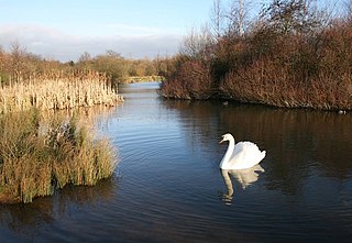
Bagnall Road Wood is a local nature reserve near Milton, on the eastern fringe of Stoke-on-Trent, England.

Branston Water Park is a local nature reserve near Burton upon Trent, in Staffordshire, England, adjacent to the village of Branston.