Staffordshire is a landlocked ceremonial county in the West Midlands of England. It borders Cheshire to the north-west, Derbyshire and Leicestershire to the east, Warwickshire to the south-east, the West Midlands county and Worcestershire to the south, and Shropshire to the west. The largest settlement is the city of Stoke-on-Trent, and the county town is Stafford.

James Brindley was an English engineer. He was born in Tunstead, Derbyshire, and lived much of his life in Leek, Staffordshire, becoming one of the most notable engineers of the 18th Century.
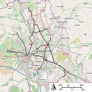
Stoke-on-Trent is a city and unitary authority area in Staffordshire, England, with an area of 36 square miles (93 km2). In 2022, the city had an estimated population of 259,965. It is the largest settlement in Staffordshire and is surrounded by the towns of Newcastle-under-Lyme, Alsager, Kidsgrove and Biddulph, which form a conurbation around the city.

The Staffordshire Potteries is the industrial area encompassing the six towns Burslem, Fenton, Hanley, Longton, Tunstall and Stoke in Staffordshire, England. North Staffordshire became a centre of ceramic production in the early 17th century, due to the local availability of clay, salt, lead and coal.

Burslem is one of the six towns that along with Hanley, Tunstall, Fenton, Longton and Stoke-upon-Trent form part of the city of Stoke-on-Trent in Staffordshire, England. It is often referred to as the "mother town" of Stoke on Trent. The population of the town was included under the Burslem Central ward and had a population of 6,490 in the 2021 Census.

Trentham Estate in the village of Trentham, Staffordshire, England, is a visitor attraction on the southern fringe of the city of Stoke-on-Trent.

Smallthorne is an area in the city of Stoke-on-Trent in Staffordshire, England. It is in the north-east of the city, near Burslem. Smallthorne borders Bradeley and Chell in the north, Norton-in-the-Moors in the east, Sneyd Green in the south, and Burslem in the west.

Longport is an area of Stoke-on-Trent, England. It is the location for Longbridge Hayes industrial estate.

Penkhull is a district of the city of Stoke-on-Trent, Staffordshire, England, part of Penkhull and Stoke electoral ward, and Stoke Central parliamentary constituency.

Werrington is a village in the Staffordshire Moorlands district of Staffordshire, England, about 5 miles (8 km) east of Stoke-on-Trent city centre. The village has a population of just over 3,000 people, sits at 875 feet (270 m) above sea level and is known for its windmill standing at the summit. It is surrounded by Wetley Moor, a Site of Special Scientific Interest, and has the A52 road running through the middle of the village.

Cobridge railway station was located on the Potteries Loop Line and served the Cobridge area of Stoke-on-Trent, Staffordshire, England. The station was located between Elder Road and Sandbach Road.

Goldenhill is an area on the northern edge of Stoke-on-Trent, in the Stoke-on-Trent district, in the ceremonial county of Staffordshire, England. It is centred along the High Street, part of the A50 road that runs from south-east to north-west. It is about 1 mile (1.6 km) north of Tunstall and 1.5 miles (2.4 km) south-east of Kidsgrove.

Chell is a suburb of the city of Stoke-on-Trent in the ceremonial county of Staffordshire, England, that can be subdivided into Little Chell, Great Chell and Chell Heath. It lies on the northern edge of the city, approximately 1-mile (1.6 km) from Tunstall, 2 miles (3.2 km) from Burslem and 3 miles (4.8 km) from the county border with Cheshire. Chell borders Pitts Hill to the west, Tunstall to the south west, Stanfield and Bradeley to the south, with the outlying villages of Packmoor and Brindley Ford to the north and Ball Green to the east. Since 2011 the area has been divided into the electoral wards of Bradeley & Chell Heath, Great Chell & Packmoor and Little Chell & Stanfield.
The Potteries Electric Traction Company operated a tramway service in The Potteries between 1899 and 1928.

Stoke-on-Trent is a city located in Staffordshire, England. The city is a linear conurbation of six constituent towns. Stoke-on-Trent is considered to be the home of the pottery industry in England and is commonly known as the Potteries. Formerly a primarily industrial conurbation, it is now a centre for service industries and distribution centres.

The Turner family of potters was active in Staffordshire, England 1756-1829. Their manufactures have been compared favourably with, and sometimes confused with, those of Josiah Wedgwood and Sons. Josiah Wedgwood was both a friend and a commercial rival of John Turner the elder, the first notable potter in the family.
Charles Lynam was an English architect, designing many public buildings and churches in the Stoke-on-Trent area. He was also a church historian, archaeologist, and preservationist.
The Old Town Hall is a former town hall in Burslem, in Staffordshire, England. It is in the Market Place, in the centre of the town. It is a Grade II* listed building, listed on 2 October 1951.

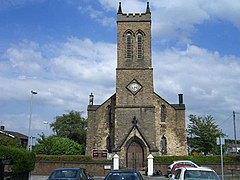
Christ Church is an Anglican church in Fenton, Staffordshire, England. It is in the parish of Stoke-upon-Trent and Fenton, and in the Diocese of Lichfield. The building is Grade II listed.