Related Research Articles

Staffordshire is a landlocked ceremonial county in the West Midlands of England. It borders Cheshire to the north-west, Derbyshire and Leicestershire to the east, Warwickshire to the south-east, the West Midlands county and Worcestershire to the south, and Shropshire to the west. The largest settlement is the city of Stoke-on-Trent, and the county town is Stafford.

Congleton is a market town and civil parish in the unitary authority of Cheshire East in Cheshire, England. It is on the River Dane, 21 miles (34 km) south of Manchester and 13 miles (21 km) north of Stoke on Trent. At the 2021 Census, it had a population of 30,015.
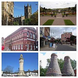
Stoke-on-Trent is a city and unitary authority area in Staffordshire, England, with an area of 36 square miles (93 km2). In 2021, the city had an estimated population of 258,400. It is the largest settlement in Staffordshire and is surrounded by the towns of Newcastle-under-Lyme, Alsager, Kidsgrove and Biddulph, which form a conurbation around the city.

East Staffordshire is a local government district with borough status in Staffordshire, England. The council is based in Burton upon Trent. The borough also contains the town of Uttoxeter and numerous villages and surrounding rural areas.

Crowle is a market town in the civil parish of Crowle and Ealand, on the Isle of Axholme in the North Lincolnshire unitary authority of Lincolnshire, England. The civil parish had a population at the 2011 census of 4,828. The town lies on the Stainforth and Keadby Canal.

Hanley is one of the six towns that, along with Burslem, Longton, Fenton, Tunstall and Stoke-upon-Trent, amalgamated to form the City of Stoke-on-Trent in Staffordshire, England.

Burslem is one of the six towns that along with Hanley, Tunstall, Fenton, Longton and Stoke-upon-Trent form part of the city of Stoke-on-Trent in Staffordshire, England. It is often referred to as the "mother town" of Stoke on Trent.

Stoke-on-Trent South is a constituency created in 1950, and represented in the House of Commons of the UK Parliament since 2017 by Jack Brereton, a Conservative. The local electorate returned a Labour MP in every election until 2017, when Brereton became its first Conservative MP. The seat is non-rural and in the upper valley of the Trent covering half of the main city of the Potteries, a major ceramics centre since the 17th century.
Bilton-in-Ainsty is a village in the civil parish of Bilton-in-Ainsty with Bickerton, in North Yorkshire, England. It lies about 4 miles (6 km) east of Wetherby and 8 miles (13 km) west of York. Bilton had a population of 147 in 2006.

Stoke-on-Trent railway station is a mainline railway station serving the city of Stoke-on-Trent, on the Stafford to Manchester branch of the West Coast Main Line. It also provides an interchange between local services running through Cheshire, Staffordshire and Derbyshire.
Ormiston Meridian Academy is a co-educational secondary school located in the Meir area of the City of Stoke-on-Trent, Staffordshire, England. The school serves the communities of Meir, Meir Park, Rough Close, Normacot and Lightwood.

Smallthorne is an area in the city of Stoke-on-Trent in Staffordshire, England. It is in the north-east of the city, near Burslem. Smallthorne borders Bradeley and Chell in the north, Norton-in-the-Moors in the east, Sneyd Green in the south, and Burslem in the west.

Fiskerton is a village and former civil parish, now in the parish of Fiskerton cum Morton, in the Newark and Sherwood district, in the county of Nottinghamshire, England. It is on the west bank of the River Trent about 3 miles southeast of Southwell. The waterfront is home to million-pound residential properties, previously residences of merchants and businessmen who commuted in the 1800s to nearby Nottingham by rail from Fiskerton Station. In 1881 the parish had a population of 283.

Owston Ferry is a village and civil parish in North Lincolnshire, England. It is situated on the west bank of the River Trent, and 9 miles (14 km) north from Gainsborough. It had a total resident population of 1,128 in 2001 including Kelfield. This increased to 1,328 at the 2011 census. Sometimes referred to as Owston or Ferry, the village forms part of the Isle of Axholme. It is bounded to the west by the A161 road and the village of Haxey. The River Trent is directly to the east. To the north, beyond a number of hamlets and villages, lies the Humber estuary. West Butterwick was originally a part of the township of Owston.

Poole is a civil parish in the unitary authority of Cheshire East and the ceremonial county of Cheshire, England, which lies to the north west of Nantwich and to the west of Crewe. The Shropshire Union Canal runs through the parish. Nearby villages include Acton, Aston juxta Mondrum, Barbridge, Stoke Bank, Rease Heath and Worleston.
The Villas, Stoke-on-Trent, is an estate of 24 Victorian houses in Stoke-upon-Trent, England. Originally a distinct settlement set in green fields, it now merges with the late 19th- and early 20th-century suburban sprawl along London Road below Penkhull village on the outskirts of Stoke-on-Trent and within the ward of Stoke and Trent Vale.

Goldenhill is an area on the northern edge of Stoke-on-Trent, in the Stoke-on-Trent district, in the ceremonial county of Staffordshire, England. It is centred along the High Street, part of the A50 road that runs from south-east to north-west. It is about 1 mile (1.6 km) north of Tunstall and 1.5 miles (2.4 km) south-east of Kidsgrove.

The Mercian Trail is the name given to a group of museums and historical sites in the West Midlands of England that will be used to display objects from the Staffordshire Hoard. The trail is organised by a partnership of Lichfield District, Tamworth Borough Council, Staffordshire County Council, Stoke-on-Trent City Council and Birmingham City Council, and features the following locations:

Bethesda Methodist Chapel is a disused Methodist chapel, in Hanley, Staffordshire, England. One of the largest Nonconformist chapels outside London, the building has been known as the "Cathedral of the Potteries", being "one of the largest and most ornate Methodist town chapels surviving in the UK".
References
- ↑ "The Lightwood Hoard - Stoke-on-Trent City Council". Archived from the original on 28 April 2009. Retrieved 2009-02-23.Description of Lightwood Hoard
- ↑ Listed buildings in Stoke-on-Trent, includes photo of chapel
- ↑ Historic England. "Methodist Chapel (1220578)". National Heritage List for England . Retrieved 6 June 2016.
52°58′12″N2°06′54″W / 52.970°N 2.115°W
| | This Staffordshire location article is a stub. You can help Wikipedia by expanding it. |