Lyme Brook

Last updated

Lyme Brook
Lyme Brook from the A500 (geograph 5002718).jpg
Lyme Brook from the A500
Staffordshire UK relief location map.jpg
Red pog.svg
Lyme brook within Staffordshire
Location
Country England
Counties Staffordshire
Physical characteristics
Mouth  
  location
Hanford, Staffordshire
  coordinates
52°58′44″N2°12′11″W / 52.979°N 2.203°W / 52.979; -2.203 Coordinates: 52°58′44″N2°12′11″W / 52.979°N 2.203°W / 52.979; -2.203
Length4.1 km (2.5 mi) [1]
Basin size31 km2 (12 sq mi) [2]
Progression : Lyme Brook—TrentHumber

Lyme Brook is a tributary stream of the River Trent, which flows through Newcastle-under-Lyme, and the outlying areas of Stoke-on-Trent in Staffordshire, England. [3] [4]

Contents

Course

Prior to the 20th century the upper course of the brook could be traced through the area to the north of Newcastle, but subsequent development and culverting means that only parts are now visible. [5]

To the south of Newcastle town centre, the brook joins together with a number of its tributaries including the Silverdale and the Ashfield brooks. This area between Rotterdam and Pool Dam was important historically, as the water from the brooks was dammed to form a protective pool around the ‘new’ motte-and-bailey castle in the 12th century, after which the town is named. [5]

From Pool Dam, the brook has been designated as main river, which flows south-east in a narrow valley, between Clayton and Trent Vale, where it forms the boundary between Newcastle and Stoke. The brook then passes next to the Clayton Wood Training Ground and under the A500 dual carriage-way, joining the Trent near Hanford. [3]

The catchment or drainage basin lies between that of the Fowlea Brook to the north and east, and that of the Park brook to the south, and has an area of 31 square kilometres (12 sq mi). [2]

Floods

The Return Road bridge over Lyme Brook -geograph- 2464396-by-Carl-Farnell.jpg
The Return

The brook is capable of causing flooding, and was the subject of a flood alleviation scheme in the 1990s by the National Rivers Authority. The completed scheme was commemorated by a sculpture on the Brook Lane bridge, known as The Return. The 1995 carved stone sculpture by local artist Ian Randall, shows a cascade of fish returning to the brook. [6]

A flood warning service is provided for the brook, and encompasses areas at risk such as, Brook Lane, Hatrell Street and the Lyme Valley sports fields. [7]

Pollution and ecology

Along with other watercourses draining the Potteries such as Ford Green Brook and the Fowlea Brook, Lyme brook suffered from pollution as the area developed following the Industrial Revolution with sewage effluent from Newcastle being discharged into the brook. The building of sewerage treatment works removed the gross pollution, but problems still persisted. [8]

Lyme brook is classed as having poor ecological quality [9] under the Water Framework Directive, having improved from bad in 2015. The bands in the five part framework scale are high, good, moderate, poor and bad. Problems include poor water quality and low levels of aquatic ecology. [4] [10] [11] Work to improve the brook is continuing and examples of improvement include the return of Brown Trout. [12]

Related Research Articles

Staffordshire County of England

Staffordshire is a landlocked county in the West Midlands of England. It borders Cheshire to the northwest, Derbyshire and Leicestershire to the east, Warwickshire to the southeast, the West Midlands County and Worcestershire to the south, and Shropshire to the west.

Stoke-on-Trent City and unitary authority in England

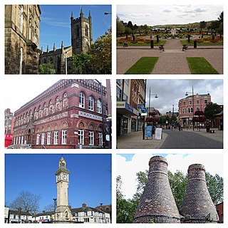
Stoke-on-Trent is a city and unitary authority area in Staffordshire, England, with an area of 36 square miles (93 km2). In 2019, the city had an estimated population of 256,375. It is the largest settlement in Staffordshire and is surrounded by the towns of Newcastle-under-Lyme, Alsager, Kidsgrove, Biddulph and Stone which form a conurbation around the city.

Newcastle-under-Lyme Market town in Staffordshire, England

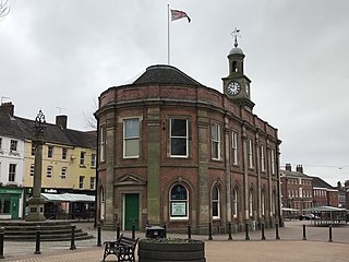
Newcastle-under-Lyme is a market town and the administrative centre of the Borough of Newcastle-under-Lyme in Staffordshire, England. Its 2011 census population was 75,082, covered by the borough had a population of 128,264 in 2016, up from 123,800 in the 2011 Census.

River Trent River in England – third-longest in the UK

The River Trent is the third-longest river in the United Kingdom. Its source is in Staffordshire, on the southern edge of Biddulph Moor. It flows through and drains the North Midlands. The river is known for dramatic flooding after storms and spring snowmelt, which in the past often caused the river to change course.

Newcastle-under-Lyme Canal

The Newcastle-under-Lyme Canal was a 3 mile 6 furlongs (6 km) level canal from the Trent & Mersey Canal at Stoke-on-Trent to Newcastle-under-Lyme. It was completed in 1800. The canal has been disused since 1935.

River Leen River in Nottinghamshire, England

The River Leen is a 15-mile (24 km) long tributary of the River Trent that flows through Nottinghamshire, and the city of Nottingham in the East Midlands of England.

Newcastle College is further education college in Newcastle-under-Lyme, Staffordshire, England.

Tunstall, Staffordshire Human settlement in England

Tunstall is one of the six towns that, along with Burslem, Longton, Fenton, Hanley and Stoke-upon-Trent, amalgamated to form the City of Stoke-on-Trent in Staffordshire, England. It was one of the original six towns that federated to form the city. Tunstall is the most northern, and fourth largest town of the Potteries. It is situated in the very northwest of the city borough, with its north and west boundaries being the city limit. It stands on a ridge of land between Fowlea Brook to the west and Scotia Brook to the east, surrounded by old tile making and brick making sites, some of which date back to the Middle Ages.

Eye Brook River in the East Midlands of England

The Eye Brook is a watercourse in the East Midlands of England and a tributary of the River Welland. It is around 18 miles (29 km) long.

River Sow River in Staffordshire, England

The River Sow is a tributary of the River Trent in Staffordshire, England, and is the river that flows through Stafford.

Basford is a suburb which sits on high ground between Newcastle-under-Lyme and Stoke-on-Trent in Staffordshire, England.

Staffordshire Fire and Rescue Service is the statutory fire and rescue service responsible for fire protection, prevention, intervention and emergency rescue in the county of Staffordshire and unitary authority of Stoke-on-Trent. The county has a population of 1,126,200 and covers a total area of 2,260 km2. Staffordshire shares the majority of its border with Derbyshire, Cheshire, West Midlands (County) and Shropshire; although, in much shorter stretches, the county also butts up against Worcestershire, Warwickshire and Leicestershire.

Lockram Brook is a small stream in southern England. It rises near the Berkshire village of Mortimer, and is a tributary of Burghfield Brook.

Ford Green Brook Stream in Staffordshire, England

Ford Green Brook flows through Staffordshire and the outlying areas of Stoke-on-Trent, England. It is the first named tributary stream of the River Trent, and is 6.2 miles (10 km) long.

River Swarbourn River in Staffordshire, England

The River Swarbourn is a minor tributary of the River Trent that flows for 10 miles (16 km) in Staffordshire, England.

Hilton Brook River in England

The Hilton Brook or Sutton Brook is a tributary of the River Dove in Derbyshire, England, and is 26 kilometres long. Like many watercourses in the area, it has multiple names, often being named locally after the village it flows past.

Fairham Brook River in Leicestershire and Nottinghamshire, England

Fairham Brook is a 16-mile-long (26 km) tributary of the River Trent that flows through Leicestershire and Nottinghamshire in England.

Fowlea Brook Stream in Staffordshire, England

Fowlea Brook flows through Staffordshire and the outlying areas of Stoke-on-Trent, England. It is a tributary stream of the River Trent, and is 6 miles (9.7 km) long.

River Bourne, Warwickshire River in Warwickshire, England

The River Bourne flows for 10.9 miles (17.6 km) through North Warwickshire, England, and is a tributary of the River Tame. In the 19th century, the river with its undeveloped catchment close to Birmingham, was selected to provide a source of clean drinking water for the city.

References

  1. Length from Pool Dam to the confluence with the Trent. Jenkins 1963
  2. 1 2 "WFD Surface Water Classification Status and Objectives 2012 csv files". Environment-agency.gov.uk. Archived from the original on 24 February 2014. Retrieved 20 April 2014.
  3. 1 2 Ordnance Survey (2006). 118 Stoke-on-Trent & Macclesfield. OS Landranger Map Series. Ordnance Survey. ISBN   9780319229064.
  4. 1 2 "Water Framework Directive - River Basin Management Plans". What's in your Backyard. Environment Agency. Archived from the original on 4 March 2016. Retrieved 11 May 2014.
  5. 1 2 J. G. Jenkins, ed. (1963). "Newcastle-under-Lyme: Introduction". A History of the County of Stafford: Volume 8. Institute of Historical Research. Retrieved 20 June 2014.
  6. "The Return". National Recording Project. public monuments and sculpture association. Archived from the original on 3 March 2016. Retrieved 20 June 2014.
  7. "Lyme Brook at Newcastle under Lyme and Trent Vale". Flood Warning Area Detail. Environment Agency. Retrieved 11 May 2014.
  8. J. G. Jenkins, ed. (1963). "Stoke-upon-Trent: Local government, economic history and social life". A History of the County of Stafford: Volume 8. Institute of Historical Research. Retrieved 20 June 2014.
  9. "Lyme Brook Catchment". Department for Environment Food & Rural Affairs. Retrieved 24 August 2022.
  10. "Bad rating for polluted brook". The Sentinel . 2013. Retrieved 20 May 2014.
  11. "Rivers and Brooks of Stoke on Trent". Canals and Waterways. thepotteries.org. Retrieved 14 March 2014.
  12. "Brown trout return to Newcastle-under-Lyme". Gov.uk. Gov.uk. Retrieved 24 August 2022.