
The Emerald Necklace consists of a 1,100-acre chain of parks linked by parkways and waterways in Boston and Brookline, Massachusetts. It was designed by landscape architect Frederick Law Olmsted, and gets its name from the way the planned chain appears to hang from the "neck" of the Boston peninsula. In 1989, the Emerald Necklace was designated as a Boston Landmark by the Boston Landmarks Commission.

The Gardens at Elm Bank, home of Massachusetts Horticultural Society, occupies 36 acres (15 ha) of Elm Bank Reservation, a 175-acre (71 ha) recreational area of woodlands, fields, and former estate property on the Charles River managed by the Massachusetts Department of Conservation and Recreation. The estate's entrance is located at 900 Washington Street, Wellesley, Massachusetts, United States, with the major portion of the grounds located in the neighboring town of Dover. In 1987, the entire site was added to the National Register of Historic Places as Elm Bank.

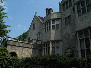
Frederick Law Olmsted National Historic Site is a United States National Historic Site located in Brookline, Massachusetts, a suburb of Boston. Frederick Law Olmsted (1822–1903) is recognized as the founder of American landscape architecture and the nation's foremost parkmaker of the 19th century. In 1883, Olmsted moved his home to suburban Boston and established "Fairsted", the world's first full-scale professional office for the practice of landscape design. Over the course of the next century, his sons and successors expanded and perpetuated Olmsted's design ideals, philosophy, and influence.
Planting Fields Arboretum State Historic Park, which includes the Coe Hall Historic House Museum, is an arboretum and state park covering over 400 acres (160 ha) located in the village of Upper Brookville in the town of Oyster Bay, New York.

Castle Hill is a 56,881 sq ft (5,284.4 m2) mansion in Ipswich, Massachusetts, which was completed in 1928 as a summer home for Mr. and Mrs. Richard Teller Crane, Jr. It is also the name of the 165-acre (67 ha) drumlin surrounded by sea and salt marsh that the home was built atop. Both are part of the 2,100-acre (850 ha) Crane Estate, located on Argilla Road. The estate includes the historic mansion, 21 outbuildings, and landscapes overlooking Ipswich Bay on the seacoast off Route 1, north of Boston. Its name derives from a promontory in Ipswich, Suffolk, England, from which many early Massachusetts Bay Colony settlers immigrated.
Charlestown Heights later known as Ensign John J. Doherty Park, is an urban park in Charlestown, a neighborhood of Boston, Massachusetts. It is one of five small urban parks designed by Frederick Law Olmsted for the city. These parks were designed to provide greenspaces in densely populated neighborhoods. Charlestown Heights was laid out on the North side of Bunker Hill, sloping down the hill from Bunker Hill Street to Medford Street, between St. Martin Street and North Mead Street.

Dorchester Park is a historic park bounded by Dorchester Avenue, Richmond, Adams and Richview Streets in the Dorchester neighborhood of Boston, Massachusetts.

Crocker Field is an outdoor sports and recreation facility for the children of the Fitchburg Public School System in Fitchburg, Massachusetts. The complex consists of a number of athletic facilities on a 5.5-acre (2.2 ha) plot of land near the Nashua River. There are indoor and outdoor playing areas, an outdoor stadium, a field house, and a ticket booth and concession stand. The site is enclosed on three sides by a wrought iron fence resting on a concrete base, with periodic square concrete pillars. Most of the complex was built in 1918, with landscaping designed by the Olmsted Brothers. The facility was listed on the National Register of Historic Places in 2001 as the Crocker Field Historic District.
Church Street Historic District is a historic district roughly on Church Street between Park Ave. and Highland St. in Ware, Massachusetts. This mainly residential area includes some of Ware's finest late 19th century houses and a well-preserved collection of Greek Revival houses. The area was developed primarily in response to the growth of industry to the south. The district was listed on the National Register of Historic Places in 1983.

Pulaski Park is a city park along the Connecticut River in Holyoke, Massachusetts. Originally called Prospect Park when it was laid out in 1884, it was given its present name in 1939 in honor of American Revolutionary War hero Casimir Pulaski, for whom there is a memorial in the park's center. The original 5.1-acre (2.1 ha) park was designed by the Olmsted Brothers landscape design firm.

Nahant Beach Boulevard, also Nahant Causeway and Nahant Road, is a historic road on the isthmus connecting Nahant, Massachusetts to the mainland at Lynn, Massachusetts, United States. The road runs from the Lynn Rotary, its junction with Lynn Shore Drive and the Lynnway, about 1.5 miles (2.4 km) to Wilson Road in Nahant. It passes through Nahant Beach Reservation, a state park offering beach access on the isthmus. The road offers expansive views of the area coastlines and Boston Harbor. Both the park and the roadway are administered by the Massachusetts Department of Conservation and Recreation.

Olmsted Subdivision Historic District is a historic district roughly bounded by New Ocean St/Paradise Road, Swampscott Avenue, Redington Street and Burrill Street in Swampscott, Massachusetts.

The Tavern Acres Historic District encompasses a residential development known as Tavern Acres, which was built in the 1920s with a landscape design by Henry Vincent Hubbard, then with the Olmsted Brothers landscape design firm. It is bounded by Bradstreet Rd., Green and Main Sts. and Park Way in North Andover, Massachusetts. The district encompasses Memorial Park, the Stevens Library, and properties facing Memorial Park and further along Bradstreet Road. The district was listed on the National Register of Historic Places in 1995.

The Middlesex Fells Reservoirs Historic District is a historic district roughly bounded by Pond St., Woodland Rd., I-93, and MA 28 in Stoneham and Medford, Massachusetts. It encompasses a portion of the Middlesex Fells Reservation, a state park managed by the Massachusetts Department of Conservation and Recreation (DCR). The principal features of the district are three reservoirs and their associated gate houses and pumping stations, which were developed by the Metropolitan District Commission starting in the late 19th century. The district was listed on the National Register of Historic Places in 1990.
The Beacon Street Historic District is a historic district running most of the length of Beacon Street in Brookline, Massachusetts, roughly from Saint Mary's Road, near Kenmore Square, to Ayr Road near Cleveland Circle. It includes a small number of properties on adjacent streets, and was listed on the National Register of Historic Places in 1985.

The Lewis Cabot Estate was a historic estate at Warren and Heath Streets in Brookline, Massachusetts. The estate, developed in 1894, was one of few surviving turn-of-the-century properties of the Boston Brahmin Cabot family, and a prominent local example of Jacobethan architecture with landscaping by Frederick Law Olmsted. The remnant portion of the estate was listed on the National Register of Historic Places in 1985; the main house has since been demolished.

The Moses-Kent House is a historic house at 1 Pine Street in Exeter, New Hampshire. Built in 1868 for a prominent local merchant, it is one of the town's finest examples of Victorian residential architecture. It was added to the National Register of Historic Places on September 12, 1985.
The Frederick Law Olmsted Summer Home, also known as Felsted, is a historic house in the town of Deer Isle, Maine. It is located on the west side of the same-named island, south of the village of Sunset. Designed by William Ralph Emerson and built in 1897, it was for one year the summer home of the famous landscape architect Frederick Law Olmsted in a bid to improve his failing mental health. Olmsted, then retired and severely affected by senility, was later committed McLean Hospital in Massachusetts, where he died in 1903. The house is a high-quality example of Shingle style architecture; it was listed on the National Register of Historic Places in 1976.

Cedar Brook Park is a 78-acre (32 ha) county park situated mostly in Plainfield in Union County, within the U.S. state of New Jersey, with a smaller portion of the park extending into South Plainfield in adjacent Middlesex County. Featuring the Shakespeare Garden, it was listed on the National Register of Historic Places on June 25, 2007, for its significance in landscape architecture. The park was designed by the Olmsted Brothers of Brookline, Massachusetts from 1924 to 1930.

Lewis Fulton Memorial Park is a public park in the city of Waterbury, Connecticut. Located north of the city center, it was developed in the 1920s through the philanthropy of William Fulton, a brass company owner, as a memorial to his son Lewis. Its grounds were designed by the Olmsted Brothers landscape architects, and were largely completed by 1925. The park includes facilities for both active and passive recreation, and retains many Olmsted-designed features. It was listed on the National Register of Historic Places in 1990.


