Sleaford is a market town and civil parish in the North Kesteven district of Lincolnshire, England. On the edge of the Fenlands, it is 11 miles north-east of Grantham, 16 mi (26 km) west of Boston, and 17 mi (27 km) south of Lincoln. It is the largest settlement in North Kesteven with a population of 19,807 in 2021. Centred on the former parish of New Sleaford, the modern boundaries and urban area include Quarrington to the south-west, Holdingham to the north-west and Old Sleaford to the east. The town is bypassed by the A17 and the A15 roads, which link it to Lincoln, Newark, Peterborough, Grantham, Boston and King's Lynn. Sleaford railway station is on the Nottingham to Skegness and Peterborough to Lincoln lines.

The Parts of Kesteven are a traditional division of Lincolnshire, England. This division had long had a separate county administration, along with the two other Parts of Lincolnshire, Lindsey and Holland.

South Kesteven is a local government district in Lincolnshire, England, forming part of the traditional Kesteven division of the county. Its council is based in Grantham. The district also includes the towns of Bourne, Market Deeping and Stamford, along with numerous villages and surrounding rural areas.

North Kesteven is a local government district in Lincolnshire, England. The council is based in Sleaford. The district also contains the town of North Hykeham, which adjoins the neighbouring city of Lincoln, along with numerous villages and surrounding rural areas.

Ancaster is a village and civil parish in the South Kesteven district of Lincolnshire, England, on the site of a Roman town. The population of the civil parish was 1,317 at the 2001 census, increasing to 1,647 at the 2011 census. The civil parish includes the settlements of Sudbrook and West Willoughby.

Anwick is a small village and civil parish in the North Kesteven district of Lincolnshire, England. The population of the civil parish at the 2011 census was 392. The village is situated 4 miles (6 km) north-east from Sleaford, on the A153 between Sleaford and Billinghay, and 16 miles (26 km) south-east from the city and county town of Lincoln.
Barkston is an English village and civil parish in the South Kesteven district of Lincolnshire. The parish population was 497 at the 2001 census and 493 at the 2011 census. The village lies about 4 miles (6 km) north of the market town of Grantham, on the A607, just south of the junction with the A153 to Ancaster.

Ruskington is a village and civil parish in the North Kesteven district of Lincolnshire, England, located approximately 4 miles (6.4 km) north of Sleaford on the north–south B1188 road and slightly north of the A153 road. The village contains approximately 2,200 dwellings and is approximately 1 mile (1.6 km) in length, measured from east to west. The population of the civil parish was 5,169 at the 2001 census, increasing to 5,637 at the 2011 census.

Aswarby and Swarby is a civil parish in the North Kesteven district of Lincolnshire, England. Aswarby is the ecclesiastical parish formed in 1850 from the two ancient parishes of Asarby and Swarby. The civil parish of Asarby and Swarby also includes Crofton. The parish therefore consists of both Aswarby and Swarby.
Leasingham is a village and civil parish in the North Kesteven district of Lincolnshire, England. It is situated less than 2 miles (3 km) north from Sleaford, and just off the A15. The hamlet of Roxholm lies to the north. When combined with Rauceby figures, there are a total of 916 households as of 2011. The population of the civil parish at the 2011 census was 1,584.

Great Hale is a village and civil parish in the North Kesteven district of Lincolnshire, England. The population of the civil parish at the 2011 census was 778. It is situated on the B1394 road, immediately south from Heckington and 1.7 miles (2.7 km) north from Helpringham.
Heckington is a village and civil parish in the North Kesteven district of Lincolnshire, England. It is situated between Sleaford and Swineshead Bridge, and south of the A17 road. Heckington, with 1,491 households, is one of the largest villages in Lincolnshire. The population of the civil parish including Boughton was 3,353 at the 2011 census.

South Rauceby is a village and civil parish in the North Kesteven district of Lincolnshire, England. It is situated 2.5 miles (4.0 km) west from Sleaford. The village of North Rauceby is less than 1 mile (1.6 km) to the north. The 2001 Census recorded a village population of 330 in 161 household, increasing to 367 at the 2011 census.
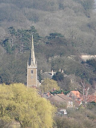
Navenby is a village and civil parish in the North Kesteven district of Lincolnshire, England. Lying 8 miles (13 km) south from Lincoln and 9 miles (14 km) north-northwest from Sleaford, Navenby had a population of 2,128 in the 2011 census and in March 2011, it was named as the 'Best Value Village' in England following a national survey.

Little Hale is a hamlet and civil parish in the North Kesteven district of Lincolnshire, England. It is situated 5 miles (8 km) south-east from the town of Sleaford, and directly south from the larger villages of Great Hale and Heckington. Adjacent villages include Burton Pedwardine, Great Hale and Helpringham. Little Hale, a village of approximately 60 houses, lies on the eastern western edge of the Lincolnshire Fens.
High Dyke is a minor road following a length of the Roman Road Ermine Street in the English county of Lincolnshire, between Woolsthorpe-by-Colsterworth and Ancaster, and onwards nearly to Bracebridge Heath. It is also the name of a small settlement on that road, 1 mile (1.6 km) south-east from Great Ponton, near to the mouth of Stoke Tunnel on the East Coast Main Line. High Dyke is also a name for the general area between Easton and Great Ponton. On the Ordnance Survey 1:25000 sheets it is spelled High Dike.

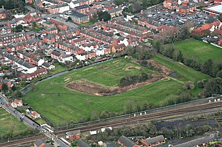
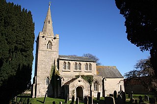
Quarrington is a village and former civil parish, now part of the civil parish of Sleaford, in the North Kesteven district of Lincolnshire, England. The old village and its church lie approximately 1 miles (2 km) south-west from the centre of Sleaford. Suburban housing developments at New Quarrington and Quarrington Hill effectively link the two settlements. Bypassed by the A15, it is connected to Lincoln and Peterborough, as well as Newark and King's Lynn. At the 2011 census, Quarrington and Mareham ward, which incorporates most of the settlement, had an estimated population of 7,046.
Kelby is a village in the civil parish of Culverthorpe and Kelby, in the North Kesteven district of Lincolnshire, England. It lies 5 miles (8 km) south-west from Sleaford, 9 miles (14 km) north-east from Grantham and 3 miles (5 km) south-east from Ancaster. Kelby was formerly a chapelry in the parish of Haydor, in 1866 Kelby became a separate civil parish, on 1 April 1935 the parish was abolished and merged with Culverthorpe to form "Culverthorpe and Kelby". In 1921 the parish had a population of 61.

Culverthorpe is a hamlet in the civil parish of Culverthorpe and Kelby, in the North Kesteven district of Lincolnshire, England. It lies 5 miles (8 km) south-west from Sleaford, 9 miles (14 km) north-east from Grantham and 3 miles (5 km) south-east from Ancaster.

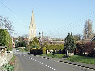
Evedon is a village in the civil parish of Ewerby and Evedon, in the North Kesteven district of Lincolnshire, England. It is situated 2 miles (3.2 km) north-east from the town of Sleaford.

