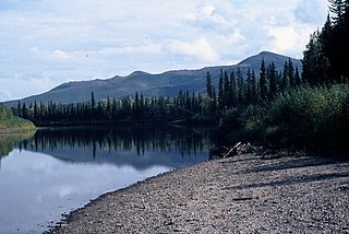
The Nowitna River is a 250-mile (400 km) tributary of the Yukon River in the U.S. state of Alaska. The river flows northeast from the Kuskokwim Mountains through Nowitna National Wildlife Refuge and enters the larger river 38 miles (61 km) northeast of Ruby and southwest of Tanana. Major tributaries include the Titna, Big Mud, Little Mud, Lost, and Sulatna rivers.

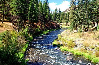
The John Day River is a tributary of the Columbia River, approximately 284 miles (457 km) long, in northeastern Oregon in the United States. Undammed along its entire length, the river is the fourth longest free-flowing river in the contiguous United States. There is extensive use of its waters for irrigation. Its course furnishes habitat for diverse species, including wild steelhead and Chinook salmon runs. However, the steelhead populations are under federal Endangered Species Act (ESA) protections, and the Chinook salmon have been proposed for such protection.
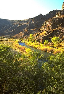
The Owyhee River is a tributary of the Snake River located in northern Nevada, southwestern Idaho and southeastern Oregon in the United States. It is 280 miles (450 km) long. The river's drainage basin is 11,049 square miles (28,620 km2) in area, one of the largest subbasins of the Columbia Basin. The mean annual discharge is 995 cubic feet per second (28.2 m3/s), with a maximum of 50,000 cu ft/s (1,400 m3/s) recorded in 1993 and a minimum of 42 cu ft/s (1.2 m3/s) in 1954.

The Koyukuk River is a 425-mile (684 km) tributary of the Yukon River, in the U.S. state of Alaska. It is the last major tributary entering the Yukon before the larger river empties into the Bering Sea.

The Flathead River, in the northwestern part of the U.S. state of Montana, originates in the Canadian Rockies to the north of Glacier National Park and flows southwest into Flathead Lake, then after a journey of 158 miles (254 km), empties into the Clark Fork. The river is part of the Columbia River drainage basin, as the Clark Fork is a tributary of the Pend Oreille River, a Columbia River tributary. With a drainage basin extending over 8,795 square miles (22,780 km2) and an average discharge of 11,380 cubic feet per second (322 m3/s), the Flathead is the largest tributary of the Clark Fork and constitutes over half of its flow.

The Andreafsky River is a 120-mile (190 km) tributary of the Yukon River in the U.S. state of Alaska. The Andreafsky flows south from near Iprugalet Mountain in the Yukon Delta National Wildlife Refuge to meet the larger river at Pitkas Point, near the village of St. Mary's.

The Aniakchak River is a stream, 27 miles (43 km) long, in Lake and Peninsula Borough on the Alaska Peninsula in the United States. It arises in Surprise Lake in the crater of Mount Aniakchak, a volcano in the Aleutian Range. It flows eastward from Aniakchak National Monument and Preserve into Aniakchak Bay and the Pacific Ocean.

The Fortymile River is a 60-mile (97 km) tributary of the Yukon River in the U.S. state of Alaska and the Canadian territory of Yukon. Beginning at the confluence of its north and south forks in the Southeast Fairbanks Census Area, the Fortymile flows generally northeast into Canada to meet the larger river 32 miles (51 km) southeast of Eagle, Alaska.
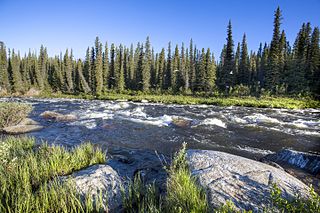
The Gulkana River is a 60-mile (97 km) tributary of the Copper River in the U.S. state of Alaska. Beginning near the southeastern end of Summit Lake in the Alaska Range, the river flows generally south to meet the larger river 9 miles (14 km) northeast of Glennallen. The Richardson Highway and the Trans-Alaska Pipeline run north–south, nearby and roughly parallel to the Gulkana River. Slightly south of Summit Lake the river passes under the east–west Denali Highway near its junction with the Richardson Highway at Paxson.
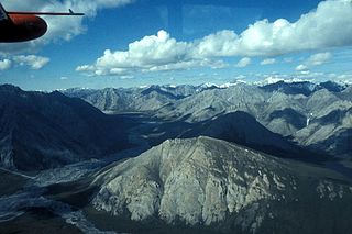
The Ivishak River is a 95-mile (153 km) tributary of the Sagavanirktok River in the North Slope Borough of the U.S. state of Alaska. Fed by glaciers at the headwaters, the Ivishak flows northeast, then northwest, through the Philip Smith Mountains and the northern foothills of the Arctic National Wildlife Refuge. It enters the Sagavanirktok River on the coastal plain south of Prudhoe Bay.

The Tinayguk River is a 44-mile (71 km) tributary of the North Fork Koyukuk River in the U.S. state of Alaska. Heading in the Endicott Mountains of the Brooks Range, the river flows generally west then south to meet the larger river about 80 miles (130 km) north of Bettles.

The Selway River is a large tributary of the Middle Fork of the Clearwater River in the U.S. state of Idaho. It flows within the Selway-Bitterroot Wilderness, the Bitterroot National Forest, and the Nez Perce National Forest of North Central Idaho. The entire length of the Selway was included by the United States Congress in 1968 as part of the National Wild and Scenic Rivers Act.
The North Fork John Day River is a 107-mile (172 km) tributary of the John Day River in the U.S. state of Oregon. It begins in Grant County about 20 miles (32 km) northwest of Baker City near the crest of the Blue Mountains. It flows generally west to the community of Dale on U.S. Route 395, then southwest through the city of Monument to the unincorporated community of Kimberly, where it meets the main stem of the John Day River.
The South Fork John Day River is a 60-mile (97 km) tributary of the John Day River in the U.S. state of Oregon. It begins in the Malheur National Forest in Harney County about 25 miles (40 km) north-northwest of Burns and flows generally north to Dayville, where it meets the main stem of the John Day River. Along the way, the stream passes through the abandoned town of Izee. Black Canyon Wilderness in the Ochoco National Forest lies within the river's drainage basin.
West Little Owyhee River is a 63.1-mile-long (101.5 km) tributary of the Owyhee River in the U.S. state of Oregon. The source of the river is at an elevation of 6,508 feet (1,984 m) near McDermitt, while the mouth is at an elevation of 4,373 feet (1,333 m) in the Owyhee Desert. West Little Owyhee River has a 310-square-mile (800 km2) watershed.

Big Jacks Creek is a 58-mile (93 km) long tributary of Jacks Creek in Owyhee County, Idaho. Beginning at an elevation of 5,935 feet (1,809 m) north of Riddle, it flows generally north and slightly east through the arid Big Jacks Creek Wilderness, before reaching its mouth southwest of Bruneau, at an elevation of 2,779 feet (847.0 m). In 2009, 35.0 miles (56.3 km) of the creek were designated as wild by the Omnibus Public Land Management Act, which also created the Big Jacks Creek Wilderness.

Roaring River is a 13.7-mile (22.0 km) tributary of the Clackamas River in Clackamas County, Oregon. Beginning near Signal Buttes on the western flank of the Cascade Range, the river flows generally west through parts of Mount Hood National Forest to meet the larger river 44 miles (71 km) from its mouth on the Willamette River.
The North Fork Owyhee River is a tributary, about 30 miles (48 km) long, of the Owyhee River in Malheur County, Oregon, and Owyhee County, Idaho, in the United States. It begins on the east flank of the Owyhee Mountains in Idaho and flows generally southwest to meet the main stem at Three Forks, Oregon, 161 miles (259 km) above the confluence of the larger river with the Snake River.
The South Fork Roaring River is a 4.6-mile (7.4 km) tributary of the Roaring River in Clackamas County in the U.S. state of Oregon. Beginning at Rock Lakes in the Mount Hood National Forest in the Cascade Range, it flows generally northwest along the base of Indian Ridge to meet the main stem. The South Fork has no named tributaries.

The North Fork Smith River is 28-mile (45 km) tributary of the Smith River that begins in the U.S. state of Oregon and ends in the U.S. state of California. Arising near Chetco Peak in the Klamath Mountains, it flows generally south to meet the Middle Fork Smith River at Gasquet, California. The combined streams form the Smith River.
