Wolf Summit, West Virginia | |
|---|---|
 Wolf Summit  Wolf Summit | |
| Coordinates: 39°16′51″N80°27′39″W / 39.28083°N 80.46083°W | |
| Country | United States |
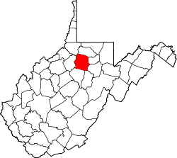
| State | West Virginia |
| County | Harrison |
| Area | |
• Total | 0.364 sq mi (0.94 km2) |
| • Land | 0.364 sq mi (0.94 km2) |
| • Water | 0 sq mi (0 km2) |
| Elevation | 1,119 ft (341 m) |
| Population (2020) | |
• Total | 214 |
| • Density | 590/sq mi (230/km2) |
| Time zone | UTC-5 (Eastern (EST)) |
| • Summer (DST) | UTC-4 (EDT) |
| Area code(s) | 304 & 681 |
| GNIS feature ID | 1556016 [2] |
Wolf Summit is a census-designated place and coal town in Harrison County, West Virginia, United States. Its population was 214 at the 2020 census (down from 272 at the 2010 census). [3] [4]
The community was named after the surname Wolf and its being the highest point on the railroad between Grafton and Parkersburg. [5]