
West Lindsey is a local government district in Lincolnshire, England. Its council is based in Gainsborough, the district's largest town. The district also includes the towns of Caistor and Market Rasen, along with numerous villages and surrounding rural areas. The east of the district includes part of the Lincolnshire Wolds, a designated Area of Outstanding Natural Beauty.

Rampton Secure Hospital is a high-security psychiatric hospital near the village of Woodbeck between Retford and Rampton in Nottinghamshire, England. It is one of three high-security psychiatric hospitals in England, alongside Ashworth Hospital in Merseyside and Broadmoor Hospital in Berkshire. It is managed by Nottinghamshire Healthcare NHS Foundation Trust.

Rampton is a village in the civil parish of Rampton and Woodbeck, about 6 miles (10 km) east of Retford in the Bassetlaw district, in the county of Nottinghamshire, England. The parish is long and thin, extending about 7 miles (11 km) east–west but only about 1 mile (1.6 km) north–south. Its eastern boundary is the River Trent, which here also forms the county boundary with Lincolnshire.

Welham is a hamlet in the civil parish of Clarborough and Welham, of Bassetlaw district, in the county of Nottinghamshire, England. It is 130 miles north of London, 28 miles north east of the city of Nottingham, and 2 miles north east of the market town of Retford.

Hodsock is a village and civil parish about 4 miles from Worksop, in the Bassetlaw district, in the county of Nottinghamshire, England. The parish includes the village of Langold and the country house Hodsock Priory. In 2021 the parish had a population of 2,603. The parish is surrounded by the settlements of Babworth, Barnby Moor, Blyth, Carlton in Lindrick, Costhorpe, Firbeck, Letwell, Maltby, Styrrup with Oldcotes and Torworth.

Scaftworth is a hamlet and civil parish within the Bassetlaw district of north Nottinghamshire, England.
Styrrup with Oldcotes is a civil parish in the Bassetlaw district, within the county of Nottinghamshire, England. The overall area had a population of 731 at the 2021 census, an increase from 684 at the 2011 census. The parish lies in the north of the county. It is 31 miles north of Nottingham, and 15 miles east of Sheffield. The parish rests alongside the county border with South Yorkshire.

Headon cum Upton is a civil parish in the Bassetlaw district, in the county of Nottinghamshire, England. The parish includes the villages of Headon, Upton and the hamlet of Nether Headon. The parish is adjacent to Askham, Gamston, East Drayton, Eaton, Grove, Rampton and Woodbeck, Stokeham and Treswell. In the 2021 census, the parish had a population of 192. The area is 3.5 miles south east of the nearest market town Retford, 26 miles north east of the county town Nottingham and 125 miles north of London. Headon cum Upton shares a parish council with Grove and Stokeham. There are 6 listed buildings in Headon cum Upton.
Rampton and Woodbeck is a civil parish in the Bassetlaw district, within the county of Nottinghamshire, England. The overall area had a population of 1,077 at the 2021 census. The parish lies in the north east of the county. It is 125 miles north west of London, 27 miles north east of the city of Nottingham, and 5 miles south east of the town of Retford. The parish rests alongside the county border with Lincolnshire. It is the site of Rampton Secure Hospital, which is one of only three high security psychiatric hospitals in England.
Headon is a village in Headon cum Upton civil parish, in the Bassetlaw district, of the county of Nottinghamshire, England. The village is adjacent to the villages of Upton, Nether Headon, East Drayton, Eaton, Gamston, Woodbeck and Stokeham. In 2011 the parish, together with Stokeham had a population of 253. The area is 3.5 miles south east of the nearest market town Retford, 26 miles north east of the county town Nottingham and 125 miles north of London. There are 2 listed buildings in Headon village.
Nether Headon is a hamlet in Headon cum Upton civil parish, within the Bassetlaw district, of the county of Nottinghamshire, England. It is 3.5 miles south east of the nearest market town Retford, 26 miles north east of the county town Nottingham and 125 miles north of London. The hamlet is adjacent to the villages of Upton, Headon, East Drayton, Eaton, Grove, Woodbeck and Stokeham. In 2011 the parish, together with Stokeham had a population of 253.

Marnham is a civil parish in the Bassetlaw district, in the county of Nottinghamshire, England. The parish includes the village of Low Marnham and the hamlets of High Marnham and Skegby. In the census of 2021 the parish had a population of 136. The parish lies in the north east of the county, and south east within the district. It is 122 miles north of London, 23 miles north east of the city of Nottingham, and 17 miles north east of the market town of Mansfield. The parish touches Fledborough, Normanton on Trent, South Clifton, Tuxford and Weston. Marnham shares a parish council with Normanton on Trent. There are 7 listed buildings in Marnham.

Norton and Cuckney is a former civil parish, now in the parish of Norton, Cuckney, Holbeck and Welbeck, in the Bassetlaw district, within the county of Nottinghamshire, England. The overall area had a population of 351 at the 2011 census. The parish lay in the north west of the county, and south west within the district. The parish lies close to the county border with Derbyshire. It is 125 miles north west of London, 20 miles north of the city of Nottingham, and 5 miles north of the market town of Mansfield. The area was bordering Sherwood Forest and has associations with mining interests and the Welbeck Estate.

Clumber and Hardwick is a civil parish in the Bassetlaw district, in the county of Nottinghamshire, England. The parish includes the settlement of Hardwick Village and Clumber Park, a country park. In the UK census of 2021 the parish had a population of 66. The parish lies in the north west of the county, and south west within the district. It is 125 miles north west of London, 22 miles north of the city of Nottingham, and 3½ miles south east of the market town of Worksop.The parish touches Babworth, Carburton, Elkesley, Perlethorpe cum Budby and Welbeck. The parish was formed on 1 April 1994. The area is within Sherwood Forest and has close historical associations with the Dukes of Newcastle, being part of a wider region known as The Dukeries. There are 26 listed buildings in Clumber and Hardwick.

South Wheatley is a village and former civil parish, now within the North and South Wheatley civil parish, of Bassetlaw district, in the county of Nottinghamshire, England. In 2001 South Wheatley parish had a population of 102. It is 130 miles north of London, 30 miles north east of the county town of Nottingham, and 5 miles north east of the Nottinghamshire town of Retford. There are 4 listed buildings in South Wheatley.

Skegby is a hamlet within the Marnham civil parish in Bassetlaw district, of the county of Nottinghamshire, England. It lies in the north east of the county, south east within the district and centre south of the parish. It is 122 miles (196 km) north of London, 23 miles (37 km) north east of the city of Nottingham, and 17 miles (27 km) north east of the market town of Mansfield. There are two listed buildings in the area.
North and South Wheatley is a civil parish in the Bassetlaw district, in the county of Nottinghamshire, England. The parish includes the villages of North Wheatley and South Wheatley. In 2021 the parish had a population of 610 residents. It is 130 miles north of London, 30 miles north east of the county town of Nottingham, and 5 miles north east of the Nottinghamshire town of Retford. The parish touches Bole, Clarborough and Welham, Clayworth, Hayton, Saundby, Sturton Le Steeple and West Burton. There are 18 listed buildings in North and South Wheatley.

Mattersey Thorpe is a small village in the Bassetlaw district of northern Nottinghamshire, England. It is 134 miles (216 km) north of London, 32 miles (51 km) north of the county town and city of Nottingham, and 5+1⁄2 miles (8.9 km) north of the town of Retford. It is in the civil parish of Mattersey.

Sookholme is a village and former civil parish, now in the parish of Warsop in the Mansfield district of western Nottinghamshire, England. It is 120 miles (190 km) north west of London, 16+3⁄4 miles (27.0 km) north of the county town and city of Nottingham, and 3+1⁄2 miles (5.6 km) north of the town of Mansfield. It retains an agricultural character, having been largely unaffected by the Industrial Revolution, which had a transformative impact on the settlement pattern and built form of numerous other settlements situated within the North Midlands coalfields. Whilst relatively close to the built up areas of Mansfield and Shirebrook, Sookholme is remote and rural. In 1931 the parish had a population of 210.
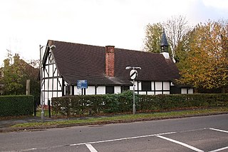
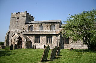
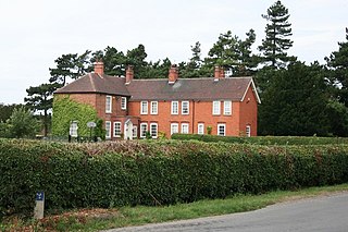
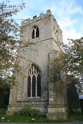
Rampton is a civil parish in the Bassetlaw District of Nottinghamshire, England. The parish contains six listed buildings that are recorded in the National Heritage List for England. Of these, two are listed at Grade I, the highest of the three grades, and the others are at Grade II, the lowest grade. The parish contains the village of Rampton and the surrounding area. The listed buildings consist of a church, two gateways, a farmhouse and associated structures, a row of cottages, and a pair of gate piers.


