Yasin Valley

Last updated
Yasin Valley
Noh Bridge.jpg
Yasin Valley, Gupis-Yasin District
Pakistan Gilgit-Baltistan location map.svg
Red pog.svg
Yasin Valley
Location in India
India location map.svg
Red pog.svg
Yasin Valley
Yasin Valley (India)
Coordinates: 36°22′15″N73°20′00″E / 36.37083°N 73.33333°E / 36.37083; 73.33333
Country India
India Gilgit Baltistan
District Gupis-Yasin District
Time zone UTC+5 (PST)

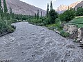
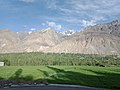
Yasin Valley is a high-altitude mountain valley nestled in the Hindu Kush mountain range, located in the northern region of the Gupis-Yasin District within the territory of Gilgit-Baltistan,Pakistan. [1] [2] The valley is situated approximately 148 kilometers (92 miles) away from the city of Gilgit, which serves as the capital of Gilgit-Baltistan. Within the valley's territory lies the Yasin Tehsil, an administrative subdivision of the region.

Contents

Yasin Valley in Summer Yasin Valley in Summer.jpg
Yasin Valley in Summer

History

Despite its sparse population, Yasin Valley has held significant strategic importance historically. This is due to the fact that it leads to a high mountain pass leading to the Yarkhun Valley and subsequently to the Broghil Pass in Chitral. These passes facilitate connectivity with the Wakhan Corridor in Afghanistan and further extends to Tajikistan.

Early period

Yasin Valley served as the administrative center of Worshigum, which was under the suzerainty of the Mehtars rulers who emerged from Chitral. The Mehtars of Yasin were great warriors and fought against the Sikhs and the Dogras of Kashmir in Gilgit Agency. But more often, they fought with each other, intrigued and murdered each other.

In 1895, the British took control of the territory under the Gilgit Agency. By this point, Yasin had become firmly recognized as part of the princely state of Jammu and Kashmir. [3]

Yasin Mehtars

*Muhammad Waizer Khan  *Ghulam Dastagir (Tham)

People

The primary languages of Yasin Valley are Burushaski language and Khowar Language. English Wakhi and Shina is also widely understood.

The majority of the people in Yasin are Ismailis, who lead their lives according to the Islamic principles more concerned with the imam of the time. Currently Aga Khan IV is the imam and spiritual leader of the Ismailis. However, other branches of both as Sunni and Shia Islam also live in Yasin. Ethnically, the people of Yasin are of Burusho origin; however, there are some migrants from different parts of the country.

The people of Yasin are known for their honesty, hard work and bravery. Havaldar Lalak Jan Shaheed who was given the Pakistan Military's highest award Nishan-e-Haider for his bravery in Kargil War in 1999, belonged to Hundur in Yasin valley.

Geography

Yasin is separated from the Ishkoman Valley by a high mountain pass. To reach Yasin one must take the Karakoram Highway north from Islamabad, and then turn left to reach Gupis in Ghizar. After Gupis, one continues northwest to reach the Yasin Valley.

The part of the valley where Khowar is spoken is known in the Shina language as Arinah. [4]

Villages

Administratively, Yasin constitutes Yasin Tehsil, which is part of Ghizer District. It is further divided into four local councils: Yasin, Sultanabad, Silgan and Thoi.

Passes

The Darkut Pass connects Yasin with Wakhan and Chitral, height 4,267 metres (13,999 ft), Buroghul pass connect Yasin with Brughol, height 3,798 metres (12,461 ft) while the Thoi Pass connects Yasin to Yarkhun Chitral, height 4,690 metres (15,390 ft). Assumber pass connects Yasin to Ishkoman. Darkot Pass is an historical pass which has been labelled as a restricted zone by the government of Pakistan. This pass used to be the shortest means of communication between the Oxus and Indus. Most tourism is along the Assumbur Pass to the Ishkoman Valley. one pass is from Darkot yasin to Thoi. Attar pass height 4,700 metres (15,400 ft) Connects Darkut with Ishkoman Valley and Attar Lake. Three passes from Nazbar yasin connect to Mastuj Chitral, height 5,009 metres (16,434 ft), one pass from Bujayote Nala to Bawoshter Ghizat Shamaran, one other pass from Khaimet bar to Chitral (sources Aina e Dardistan By Hidayat ullah Akhter, edited by Javed sajid Sultanabad Yasin).[ citation needed ]

Related Research Articles

<span class="mw-page-title-main">Gilgit</span> Capital city in Gilgit–Baltistan, a region administered by Pakistan

Gilgit is a city in Pakistani-administered Gilgit–Baltistan in the disputed Kashmir region. It is the capital of the Gilgit-Baltistan region. The city is located in a broad valley near the confluence of the Gilgit and the Hunza rivers. It is a major tourist destination in Pakistan, serving as a hub for trekking and mountaineering expeditions in the Karakoram mountain range.

<span class="mw-page-title-main">Chitral District</span> Former district of Khyber Pakhtunkhwa, Pakistan; 1969–2018

Chitral District was a district in the Malakand Division of the Pakistani province of Khyber Pakhtunkhwa, from 14 August 1947 to 2018. It was the largest district in the Khyber-Pakhtunkhwa, covering an area of 14,850 km², before splitting into Upper and Lower Chitral Districts in 2018. It was the northernmost district of Khyber Pakhtunkhwa. It shared a border with Gilgit-Baltistan to the east and with Swat and Dir districts of Khyber Pakhtunkhwa to the south. It also shared an international border with Afghanistan to the north and west. Afghanistan's narrow strip of Wakhan Corridor separated Chitral from Tajikistan in the north.

<span class="mw-page-title-main">Ghizer District (1974–2019)</span>

The Ghizer District, was a district in the westernmost part of the Gilgit-Baltistan region of Pakistan, before splitting into the current Ghizer and Gupis-Yasin districts in 2019. The capital of the district was Gahkuch.

<span class="mw-page-title-main">Shandur Pass</span> Mountain pass in Pakistan

Shandur Pass(Urdu: شندور) is a pass located within the Ghizer District of Gilgit Baltistan, Pakistan. It is often referred to as 'The Roof of the World.

<span class="mw-page-title-main">Geography of Gilgit-Baltistan</span>

Gilgit-Baltistan is an administrative territory of Pakistan in the northern part of the country. It was given self-governing status on August 29, 2009. Gilgit-Baltistan comprises 14 districts within three divisions. The four districts of Skardu Kharmang Shigar and Ghanche are in the Baltistan Division, four districts of Gilgit Ghizer Hunza and Nagar districts which were carved out of Gilgit District are in the Gilgit Division and the third division is Diamir, comprising Chilas and Astore. The main political centres are the towns of Gilgit and Skardu.

<span class="mw-page-title-main">Kho people</span> Ethnolinguistic group in Pakistan

The Kho or Chitrali people, are an Indo-Aryan ethnolinguistic group native to the Chitral District in Khyber Pakhtunkhwa and the Gupis-Yasin and Ghizer districts in Gilgit-Baltistan of Pakistan. They speak an Indo-Aryan language called Khowar.

Karambar Pass is a high mountain pass in Pakistan. It connects the Yarkhun River valley in Pakistan's upper Chitral District to the Karambar river valley in Ishkoman tehsil of Ghizer district in Hunza Valley. Sometimes it is misspelled as Karomber or Kromber pass.

<span class="mw-page-title-main">Mastuj Tehsil</span> Administrative sub-division in Pakistan

Mastuj is a tehsil of Upper Chitral District in Khyber-Pakhtunkhwa province of Pakistan; Mastuj is the principal settlement. It is located at 36°17'0N 72°31'0E with an altitude of 2359 metres. There are ruins of old fort built originally in 18th century and reconstructed several times.

The Katoor dynasty was a dynasty, which along with its collateral branches ruled the sovereign, later princely state of Chitral and its neighbours in the eastern Hindu Kush region for over 450 years, from around 1570 until 1947. At the height its power under Mehtar Aman ul-Mulk the territory controlled by the dynasty extended from Asmar in the Kunar Valley to Sher Qilla in the Gilgit valley. The Mehtar of Chitral was an influential player in the power politics of the region as he acted as an intermediary between the rulers of Badakhshan, the Yousafzai pashtuns, the Maharaja of Kashmir and later the Amir of Afghanistan.

<span class="mw-page-title-main">Tourism in Gilgit-Baltistan</span> Overview of the tourism industry in Gilgit-Baltistan, Pakistan

Tourism in Gilgit-Baltistan, an administered territory of Pakistan, focuses on its access to various mountain ranges and alpine terrain.

Niat Qabool Hayat Kakakhel was a Gilgit-Baltistani politician in Pakistan and, after 1973, assistant to the Governor of Gupis. Kakakhel was a member of the Central Asia Supreme Council and a senior member of the Aga Khan Council. He was a ruling official during the Frontier Crimes Regulations (FCR) period in the early 1970s.

<span class="mw-page-title-main">Golaghmuli Valley</span> Meadow in Gilgit-Baltistan, Pakistan

Golaghmuli Valley or Koh-i-Ghizer or Valley of Martyrs or Shandur Valley is a high mountainous valley located in the Gupis–Yasin District of Gilgit-Baltistan, Pakistan.

<span class="mw-page-title-main">Khalti Lake</span> Reservoir in Gilgit-Baltistan, Pakistan

Khalti Lake is situated in Gupis-Yasin District, the westernmost part of the Gilgit–Baltistan region and northernmost territory of Pakistan. This lake is an important source of fresh water and has a stock of trout. A PTDC motel is situated nearby with a view of the lake. The water is extremely cold which flows directly from surrounding glaciers. The lake usually freezes in winter season and people can easily walk on it.

Baha Lake is situated in Shandur Valley Tehsil Gupis of Ghizer District, Ghizer District, the westernmost part of the Northern Areas and northernmost territory of Pakistan. This lake is an important source of fresh water with full of trout.

Handarap Lake is a high altitude water reservoir situated in the Shandur Valley in Gupis-Yasin District, the westernmost part of the Gilgit-Baltistan, the northernmost part of Pakistan. The lake is an important source of fresh water and also a tourist attraction. It houses trout originating in the rivers.

<span class="mw-page-title-main">Gupis Tehsil</span> Area of northern Pakistan

Gupis Tehsil is an administrative division of Gupis-Yasin District, in Gilgit-Baltistan, a northern region of Pakistan. Gupis lies in the southern part of the Gupis-Yasin District. There are many villages and lush green and very pleasant places and resort and historical places like Yangal, Sumal, Hakis, Jindrote, Dahimal, Pingal and Khasunder.

<span class="mw-page-title-main">Aman ul-Mulk</span> The Mehtar of Chitral

Aman ul-Mulk was the Mehtar of Chitral, Ghizer, Yasen and Ishkoman and Suzerain of Kafiristan. He ruled the State of Chitral from 1857 to 1892. His rule saw Chitral reach its territorial peak, extending from Ishkamun in Gilgit Agency to Asmar in Afghanistan. His death led to the Siege of Chitral, an instance of high drama which goes down in the annals of British India as an epic of enormous courage and determination.

Sher Qilla Valley: or Sherqilla is a village in Ghizer District, 38 kilometres from Gilgit, Pakistan. It is the largest village of Ghizer District by area. The Ghizer District ضلع غذر‎ formed in 1974 is the westernmost part of the Gilgit-Baltistan region of Pakistan. Currently, it is proposed to split Ghizer District into two 2 districts.

  1. The western part of Ghizer District includes the actual Ghizer/ Ghizer Valley of Phander, Gupis and Yasin. The name as Ghizer District will be kept with this region due to the connectivity to its origin.
  2. While the eastern part of the current District will include Puniyal and Ishkoman. And probably the newly district would be given the name as Puniyal-Ishkoman District.
  3. Sherqilla Valley is located in eastern part of Ghizer District. The tehsil of Sherqilla valley is Puniyal.
<span class="mw-page-title-main">Gupis-Yasin District</span> District in Gilgit-Baltistan, Pakistan

The Gupis-Yasin District lies in the Gilgit-Baltistan region of Pakistan. It is the westernmost of the 14 districts in Gilgit-Baltistan.

<span class="mw-page-title-main">Ghizer District (2019–)</span> District of Gilgit-Baltistan administered by Pakistan

Ghizer District is a district of Pakistan-administered Gilgit-Baltistan region in the disputed Kashmir region. It is one of the 14 districts of Gilgit-Baltistan. The former Ghizer District that existed from 1974 to 2019 spanned the entire upper Gilgit River Valley. In 2019, the former district was divided into the Gupis-Yasin District in the west and the present, smaller Ghizer District in the east.

References

  1. "Yasin Valley in Ghizer District". Pamirtimes.net. 14 September 2017. Retrieved 8 September 2018.
  2. "Yasin Valley, Ghizer District, Gilgit-Baltistan". www.merawatan.pk. Retrieved 8 September 2018.
  3. Military Report and the Gazetteer of Gilgit Agency and the Independent Territories of Tangir and Darel (Second ed.), Government of India Press, 1928, pp. 55–59: "Owing to this succession of murders, the Government of India determined to separate the Khushwakt country from Chitral, and this resolution was given effect to in September 1895, when Shuja-ul-Mulk was confirmed as Mehtar of Chitral, and Governors were appointed on behalf of the Kashmir Durbar to rule over the Khushwakt districts of Yasin and Kuh, to which Ghizr was added in 1905."
  4. Grierson, George A. (1919). Linguistic Survey of India. Vol. VIII, Part 2, Indo-Aryan family. North-western group. Specimens of the Dardic or Piśācha languages (including Kāshmiri). Calcutta: Office of the Superintendent of Government Printing, India. p. 133.

Page of Yasin valley BABA E YASIN