Ynysddu

Last updated • 4 min readFrom Wikipedia, The Free Encyclopedia

Ynysddu
Graig View, Ynysddu - geograph.org.uk - 1772244.jpg
High Street
Caerphilly UK location map.svg
Red pog.svg
Ynysddu
Location within Caerphilly
Population3,948 (2011) [1]
OS grid reference ST180925
Principal area
Preserved county
Country Wales
Sovereign state United Kingdom
Post town NEWPORT
Postcode district NP11
Post townBLACKWOOD
Postcode district NP12
Dialling code 01495
Police Gwent
Fire South Wales
Ambulance Welsh
UK Parliament
Senedd Cymru – Welsh Parliament
List of places
UK
Wales
Caerphilly

51°37′36″N3°11′10″W / 51.6267°N 3.1861°W / 51.6267; -3.1861

Contents

2024 Wales Caerphilly Community Ynysddu map.svg
Map of the community
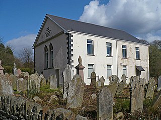
Sardis Community Chapel Sardis Community Chapel, Ynysddu - geograph.org.uk - 429398.jpg
Sardis Community Chapel

Ynysddu is a small village and community in the Sirhowy valley of south-east Wales. It is part of the district of Caerphilly within the historic boundaries of Monmouthshire. It lies between to Cwmfelinfach and Wyllie, 4.3 miles (6.9 km) north of the town of Risca and 4 miles (6.4 km) south of the market town of Blackwood. It is about 10 minutes by road from the M4 motorway and 20 minutes from the Second Severn Crossing. The population in 2008 was 2,905, [2] increasing to 3,948 at the 2011 Census.

The community includes the settlements of Cwmfelinfach, Wyllie and Wattsville.

History

Ynysddu was founded in the early 19th century by the enlightened local colliery owner John Hodder Moggridge, who lived at nearby Woodfield Park. [3] It got its name from Ynsyddu Farm, which was built by Moggridge in 1804. Ynysddu comes from the Welsh descriptive words 'Ynys' ('island' or 'river meadow') and 'ddu' ('black'). [4] [5] 'Black river meadow' is appropriate for the landscape of the area.

After he became alarmed at the terrible living conditions of the poor in the 1820s Moggridge also built 'The Ranks'. Founded as a social experiment 'The Ranks', like similar properties in Blackwood, allowed a few workers to lease a plot of land to build a cottage and garden allotment. 'The Ranks' were situated near the Black Prince pub, but have long since disappeared.

In 1901 Kelly's Directory of Monmouthshire said:

"YNYSDDU is a hamlet of this parish, having a station on the Sirhowy section, London and North Western railway, 10¼ miles north-west from Newport. Here are Baptist and Calvinistic and Primitive Methodist chapels.

Post Office.—John Hughes, sub-postmaster. Letters received through Newport at 8.55 a.m.; dispatched, 6.30 p.m. weekdays only. Postal orders are issued here, but not paid. Pontllanfraith is the nearest money order & Blackwood the nearest telegraph office Board School, erected in 1877, at a cost of £1,500, & erected in 1899, for 167 children; average attendance, 101; Thomas Harries Phillips, master; Miss Susanna Evans, assistant mistress. Railway Station, James Williams, station master" [6]

Transport

A view of Bedwas and Caerphilly from a side path through Ynys Hywel Activity Centre, which diverts from the main NCN 47 just before Cwmfelinfach. Celtic Trail.jpg
A view of Bedwas and Caerphilly from a side path through Ynys Hywel Activity Centre, which diverts from the main NCN 47 just before Cwmfelinfach.

The village is served by regular buses operated by Stagecoach Group to Tredegar and Blackwood in the north, and Newport city centre in the south.

Ynysddu is also part of the Celtic Trail cycle route (National Cycle Route 47) which connects West Wales from Fishguard through to Carmarthen, Llanelli, Swansea, Merthyr Tydfil, Newport, and the Severn Bridge in the East.

Ynysddu Bus Timetable [7]
ProviderNumberDestinationJourney timeFrequency
Stagecoach Group 56 Tredegar Bus Station 33 minutesHourly
Stagecoach Group 56 Blackwood Interchange (Stand 9)11 minutesHourly
Stagecoach Group 56 Newport Bus Station (Market Square)35 minutesHourly

Notable people

See also Category:People from Ynysddu

Education

Ynysddu Primary School is located in the town; its headmaster as of 2014 was David Witchell.

Sport and leisure

Ynysddu Rugby Club is a member of the Welsh Rugby Union and is a feeder club for the Newport Gwent Dragons. The first Ynysddu game recorded was in 1894 against Abercarn, and was played in the church field at Mynyddislwyn. Ynysddu originally played in an all-black strip, but now play in Black and Red.

Association Football in Ynysddu began in 1905, with the launch of Ynysddu Albion AFC. The club then changed its name to Ynysddu Crusaders AFC in 1915, and existed until the outbreak of WWII in 1939, when it disbanded. The two local wartime clubs, Ynysddu Celtic and Cwmfelinfach Rangers, then merged at the end of WWII in 1945/6 to become Ynysddu Welfare AFC. Following the formal amalgamation of Ynysddu Welfare AFC and Crusaders Seniors AFC in 2008, (the latter having superseded Cwmfelinfach Colts AFC in 2003), the club then became Ynysddu Crusaders FC until the summer of 2013 when the club renamed themselves Ynysddu Welfare FC. They are affiliated to the Gwent County Football Association and are members of the Gwent Premier League (Tier 4 level in the FAW National Pyramid System), with the reserve team playing in the North Gwent Football League. Club Colours are gold and black. They play their home games at the Nine Mile Point Miners' Welfare Ground at Graig View, which they share with Ynysddu RFC.

Nearby is the Sirhowy Valley Country Park. The Ynys Hywel Activity Centre, located there, offers adventure activities such as abseiling, canoeing, mountain biking, rock climbing, orienteering and hill-walking. The Ynysddu Hotel is located in the village.

Related Research Articles

<span class="mw-page-title-main">Abercarn</span> Human settlement in Wales

Abercarn is a town and community in Caerphilly county borough, Wales. It is 10 miles (16 km) northwest of Newport on the A467 between Cwmcarn and Newbridge, within the historic boundaries of Monmouthshire.

<span class="mw-page-title-main">Islwyn</span> Former district of Gwent, Wales

The Borough of Islwyn was one of five local government districts of Gwent from 1974 to 1996.

<span class="mw-page-title-main">Caerphilly County Borough</span> County borough in Wales

Caerphilly County Borough is a county borough in the south-east of Wales. It is governed by Caerphilly County Borough Council.

<span class="mw-page-title-main">Risca</span> Human settlement in Wales

Risca is a town in the Caerphilly County Borough and the historic boundaries of Monmouthshire in south-east Wales. Risca has a railway station, re-opened on the Ebbw Valley Railway in February 2008, after a gap of 46 years. It is split into two communities; Risca East and Risca West. It has a population of 11,700. Cardiff the capital of Wales can be reached in under 28 minutes from the nearby railway station of Risca and Pontymister station which reopened in 2008 after a gap of nearly 60 years.

<span class="mw-page-title-main">Blackwood, Caerphilly</span> Human settlement in Wales

Blackwood is a town, community and an electoral ward on the Sirhowy River in the South Wales Valleys administered as part of Caerphilly County Borough. It is located within the historic county of Monmouthshire.

Cwmfelinfach is a small village located in the Sirhowy valley of south-east Wales. It is part of the district of Caerphilly within the historic boundaries of Monmouthshire. It is located north of Wattsville, about 5 miles north of the nearest town Risca, and south of Blackwood. To the east the valley is bordered by the hills of Pen-y-Trwyn. To the west is Mynydd y Grug.

<span class="mw-page-title-main">Pontllanfraith</span> Human settlement in Wales

Pontllanfraith is a large village and community located in the Sirhowy Valley in Caerphilly County Borough, Wales, within the historic boundaries of Monmouthshire. It is situated adjacent to the town of Blackwood, with the Sirhowy River passing through both locations. The village includes the communities of the Penllwyn, Springfield and The Bryn. The population of the community at the 2011 census was 8,552.

Mynyddislwyn was a civil parish and urban district in Monmouthshire, south east Wales. It was abolished in local government reorganisation in 1974. It is named for the Mountain in its centre MynyddIslwyn.

<span class="mw-page-title-main">Bedwellty</span>

Bedwellty is a small village in Caerphilly County Borough in south Wales. The village stands on a ridge of high ground between the Rhymney and Sirhowy valleys. The village comprises St Sannan's parish church, public house and a few houses. The register of St Sannan's Church dates from 1624, which qualifies Bedwellty as an ancient parish. Historically the parish lay in the county of Monmouthshire, the hundred of Wentloog, Tredegar County Court District, the rural deanery of Bedwellty, the archdeaconry of Monmouth and the diocese of Llandaff. Several towns based on the iron industry expanded within the parish boundary, including from west to east, Rhymney, Tredegar and Ebbw Vale, which gradually gained administrative independence from Bedwellty between the 1870s and 1890s. A Bedwellty Local Government District was established for the rest of the parish in 1891, becoming an urban district in 1894.

Wyllie is a small village south of Blackwood in Ynysddu community, county borough of Caerphilly, within the historic boundaries of Monmouthshire, Wales.

<span class="mw-page-title-main">Gwent (county)</span> Preserved county in south-east Wales

Gwent is a preserved county and former local government county in southeast Wales. A county of Gwent was formed on 1 April 1974, under the Local Government Act 1972; it was named after the ancient Kingdom of Gwent. The authority was a successor to both the administrative county of Monmouthshire and the county borough of Newport.

<span class="mw-page-title-main">William Thomas (Islwyn)</span>

William Thomas, bardic name Islwyn, was a Welsh language poet and Christian clergyman. His best known poems were both called Yr Ystorm ['The Storm'], and were written in response to the sudden death of his fiancée.

The Sirhowy Valley is an industrialised valley in the eastern part of the Valleys region of Wales. It is named from the Sirhowy River which runs through it. Its upper reaches are occupied by the town of Tredegar within the county borough of Blaenau Gwent. The valley initially runs south-southeast between the ridges of Cefn Manmoel to the east and Mynydd Bedwellte to the west before turning to a more southerly direction. Its central section is one of the least populated of the Welsh coalfield valleys. The valley enters the county borough of Caerphilly, which contains the towns of Blackwood and Pontllanfraith. It then turns east and joins the valley of the Ebbw River, Ebbw Vale at Crosskeys.

Oakdale is a large village in Caerphilly county borough, Wales, 9½ miles north of Caerphilly itself, within the historic boundaries of Monmouthshire. Situated in the Sirhowy valley, it is 1.5 miles (2.4 km) east of Blackwood, with which it forms a conurbation. At the 2001 census Oakdale had a population of 4,478.
<span class="mw-page-title-main">Penmaen, Caerphilly</span> Human settlement in Wales

Penmaen is a hamlet and community in Caerphilly county borough, south Wales, within the historic boundaries of Monmouthshire. It is situated in the Sirhowy valley, 3 miles (4.8 km) East of Blackwood. It is contiguous with, if not completely encompassed by, the larger village of Oakdale, which forms most of the community urban area.

<span class="mw-page-title-main">Oakdale Colliery</span>

Oakdale Colliery was a coal mine located in the Sirhowy Valley, one of the valleys of South Wales.

<span class="mw-page-title-main">Argoed, Caerphilly</span> Human settlement in Wales

Argoed is a village, community and an electoral ward in the Sirhowy Valley between Blackwood and Tredegar in Caerphilly County Borough in south Wales. The population of the community and ward at the 2011 census was 2,769. As a community, Argoed also contains the villages of Markham and Hollybush.

<span class="mw-page-title-main">Crosskeys</span> Human settlement in Wales

Crosskeys is a village, community and an electoral ward in Caerphilly county borough in Wales.

Ynysddu Welfare Football Club was a Welsh football team based in Ynysddu, a small village and community of the lower Sirhowy Valley in south-east Wales. Their last season was played in the Gwent County League Division One, which is the fifth tier of the FAW Pyramid System.

References

  1. "Community population 2011" . Retrieved 8 November 2011.
  2. Caerphilly existing electoral arrangements
  3. Moggridge, a vocal opponent of the truck system, founded the model workers' town Blackwood. He was the son of John Moggridge (died 1803), a wealthy clothier of Bradford-upon-Avon; he married Sarah, daughter of M. Jeffreys, of Blakebrook, Worcester. He lived at Llanrumney Hall in 1812–23
  4. A Pocket Guide to the Place-names of Wales : Hywel Wyn Owen :Publisher: University of Wales Press : ISBN   978-0-7083-1458-6
  5. Wild Britain: Welsh place names
  6. Kelly's Directory of Monmouthshire
  7. "56 Bus Route & Timetable: Newport - Tredegar | Stagecoach". www.stagecoachbus.com. Retrieved 9 August 2019.
  8. "Storm, Y" Gyntaf gan Islwyn : Meurig Walters ISBN   978-0-7083-0754-0
  9. Oakdale village
  10. Monmouthshire Writers. A Literary History And Anthology : W.J.Townsend ("Dromio") Collins : Publisher: R.H.Johns Ltd. ISBN B001G6J3ZK