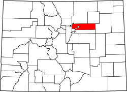
Adams City, Colorado

Last updated
Adams City, Colorado
USA Colorado location map.svg
Red pog.svg
Adams City, Colorado
Location within Colorado
Usa edcp location map.svg
Red pog.svg
Adams City, Colorado
Location within the United States
Coordinates: 39°49′36″N104°55′44″W / 39.82667°N 104.92889°W / 39.82667; -104.92889 Coordinates: 39°49′36″N104°55′44″W / 39.82667°N 104.92889°W / 39.82667; -104.92889
Country Flag of the United States.svg  United States
State Flag of Colorado.svg  Colorado
Counties Adams [1]
Founded1903
Elevation
[1]
5,135 ft (1,565 m)
Time zone UTC-7 (MST)
  Summer (DST) UTC-6 (MDT)

Adams City is an unincorporated community located in Adams County, Colorado, United States. [1] Much of it was incorporated into Commerce City in 1952.

Contents

History

Adams City was laid out in 1903, with developers hoping the county seat would be established there; however, Brighton was elected county seat in 1904, and Adams City was vacated in 1922. In 1946 and 1947, Adams County School District 14 was formed from surrounding schools, and Adams City was redeveloped about that time. On 1952-07-08, area residents voted 251 to 24 to incorporate Commerce Town (later renamed Commerce City), which includes southern Adams City.

Geography

Adams City is located at 39°49′36″N104°55′44″W / 39.82667°N 104.92889°W / 39.82667; -104.92889 (39.8266528,-104.9288672). [1]

Education

Adams County School District 14 serves the community today.

Notable person

Related Research Articles

Adams County, Illinois County in Illinois, United States

Adams County is the westernmost county in the U.S. state of Illinois. As of the 2020 census, the population was 65,737. Its county seat is Quincy. Adams County is part of the Quincy, IL–MO Micropolitan Statistical Area.

Adams County, Colorado County in Colorado, United States

Adams County is a county located in the U.S. state of Colorado. As of the 2020 census, the population was 519,572. The county seat is Brighton. The county is named for Alva Adams, an early Governor of the State of Colorado in 1887–1889. Adams County is part of the Denver–Aurora–Lakewood, CO Metropolitan Statistical Area.

Franklin County, Illinois County in Illinois, United States

Franklin County is a county in Southern Illinois. At the 2020 census, it had a population of 37,804. The largest city is West Frankfort and the county seat is Benton. This area of Southern Illinois is known locally as "Little Egypt".

Christian County, Illinois County in Illinois, United States

Christian County is a county located in the U.S. state of Illinois. As of the 2010 census, the population was 34,800. Its county seat is Taylorville. Christian County comprises the Taylorville, IL Micropolitan Statistical Area, which is also included in the Springfield-Jacksonville-Lincoln, IL Combined Statistical Area.

Brown County, Illinois County in Illinois, United States

Brown County is a county located in the U.S. state of Illinois. As of the 2010 census, the population was 6,937. Its county seat is Mount Sterling.

Commerce City, Colorado City in Colorado, United States

The City of Commerce City is a home rule municipality located in Adams County, Colorado, United States. The city population was 62,418 at the 2020 United States Census, a +35.95% increase since the 2010 United States Census. Commerce City is the 18th most populous municipality in Colorado. Commerce City is located north of Denver and is a part of the Denver–Aurora–Lakewood, CO Metropolitan Statistical Area and the Front Range Urban Corridor. Commerce City is a mixed residential and industrial community that is known for an oil refinery with a capacity of 90,000 barrels per day (14,000 m3/d), operated by Suncor. Dick's Sporting Goods Park, a soccer stadium in Commerce City, hosts the Colorado Rapids of Major League Soccer.

Northglenn, Colorado City in Colorado, United States

The City of Northglenn is a home rule municipality located in Adams and Weld counties, Colorado, United States. Northglenn is a part of the Denver–Aurora–Lakewood, CO Metropolitan Statistical Area. As of the 2010 census the city's population was 35,789. It was built as a master planned community in 1959 by Jordon Perlmutter.

Thornton, Colorado City in Colorado, United States

The City of Thornton is a home rule municipality located in Adams and Weld counties, Colorado, United States. The city population was 141,867, all in Adams County, at the 2020 United States Census, an increase of +19.44% since the 2010 United States Census. Thornton is the sixth most populous city in Colorado and the 191st most populous city in the United States. Thornton is 10 miles (16 km) north of the Colorado State Capitol in Denver and is a part of the Denver–Aurora–Lakewood, CO Metropolitan Statistical Area.

Cherry Hills Village, Colorado City in Colorado, United States

The City of Cherry Hills Village is a home rule municipality located in Arapahoe County, Colorado, United States. The city population was 6,442 at the 2020 United States Census. Cherry Hills Village is a part of the Denver–Aurora–Lakewood, CO Metropolitan Statistical Area and the Front Range Urban Corridor.

Castle Pines, Colorado City in Colorado, United States

The City of Castle Pines is a home rule municipality located in Douglas County, Colorado, United States. The city population was 11,036 at the 2020 United States Census. Castle Pines is a part of the Denver–Aurora–Lakewood, CO Metropolitan Statistical Area and the Front Range Urban Corridor. The city is located north of the Town of Castle Rock and south of the City of Lone Tree, Colorado.

Evans, Colorado City in Colorado, United States

The City of Evans is a home rule municipality located in Weld County, Colorado, United States. The city population was 22,165 at the 2020 United States Census, a 19.57% increase since the 2010 United States Census. Evans is a part of the Greeley, CO Metropolitan Statistical Area and the Front Range Urban Corridor.

Lincoln Center, Kansas City in Lincoln County, Kansas

Lincoln Center, more commonly known as Lincoln, is a city in and the county seat of Lincoln County, Kansas, United States. As of the 2020 census, the population of the city was 1,171.

S.N.P.J., Pennsylvania Borough in Pennsylvania, United States

S.N.P.J. is a borough in Lawrence County, Pennsylvania, United States. As of the 2020 Census, the borough had a population of 15.

Newcastle, Wyoming City in Wyoming, United States

Newcastle is a city in and the county seat of Weston County, Wyoming, United States. The population was 3,374 at the 2020 census.

Colorado's 6th congressional district is a congressional district in the U.S. state of Colorado. Located in central Colorado, the district encompasses much of the eastern part of the Denver metropolitan area, including all of Aurora, as well as portions of the southern and northern metro area.

Henderson, Colorado Unincorporated community in Colorado, United States

Henderson, formerly known as Henderson Island, is an unincorporated community and a U.S. Post Office in Adams County, Colorado, United States. Henderson has the ZIP Code 80640. Portions of the Henderson area have been annexed by Commerce City, Brighton, and Thornton.

Jasper, Ohio

Jasper is an unincorporated community in eastern Newton Township, Pike County, Ohio, United States. It has a post office with the ZIP code 45642. It lies at the intersection of State Routes 32, 104, and 124 along the banks of the Scioto River.

Reunion, Commerce City, Colorado

Reunion is a master-planned community in Commerce City, Adams County, Colorado, United States. The Commerce City, Colorado Post Office serves Reunion.

Powellton was an unincorporated community in Butte County, California, USA. It lies at an elevation of 3,622 feet. The place is named for R.P. Powell who arrived in 1853. Originally Powell's Ranch, it was renamed when a post office was established in 1872; the office closed in 1906. It was a center of lumber production in its heyday, but nothing remains at the site.

Antioch is an unincorporated community in the southwestern part of Wright Township, Greene County, Indiana, United States. It lies near the intersection of County Road 575 North and County Road 500 North, which is a community nearly twenty miles west of the city of Bloomfield, the county seat of Greene County. Its elevation is 531 feet, and it is located at 39°05′55″N87°14′15″W.

References

  1. 1 2 3 4 "US Board on Geographic Names". United States Geological Survey. 2007-10-25. Retrieved 2008-01-31.
  2. Lucille M. Colacito profile, ancestry.com; accessed July 3, 2020.