Barr Lake, Colorado

Last updated

Barr Lake, Colorado
USA Colorado location map.svg
Red pog.svg
Barr Lake
Usa edcp location map.svg
Red pog.svg
Barr Lake
Coordinates: 39°56′40″N104°46′31″W / 39.94444°N 104.77528°W / 39.94444; -104.77528
Country United States
State Colorado
County Adams
Elevation
5,115 ft (1,559 m)
Time zone UTC-7 (Mountain (MST))
  Summer (DST) UTC-6 (CDT)
Area codes 303, 720, & 983
GNIS feature ID184609 [1]

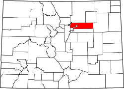
Barr Lake is an unincorporated community in Adams County, in the U.S. state of Colorado. [1] It is located within the Denver metropolitan area.

It is located next to the Barr Lake State Park.

School District 27J serves Barr Lake. Kids attend Henderson Elementary School and Prairie View Middle School.

Barr Lake was named for a Mr. Barr, a civil engineer for the Chicago, Burlington and Quincy Railroad. It was originally named Platte Summit. [2]

See also

Flag of Colorado.svg  Coloradoportal

Related Research Articles

<span class="mw-page-title-main">Strasburg, Colorado</span> Census Designated Place in Colorado, United States

Strasburg is an unincorporated town located just 30 minutes east of downtown Denver along the I-70 corridor. It is home to Strasburg School District 31-J, and there are several small businesses, medical clinics, and a post office. Strasburg is a census-designated place (CDP) located in and governed by Adams and Arapahoe counties, Colorado, United States. The CDP is a part of the Denver–Aurora–Lakewood, CO Metropolitan Statistical Area. The Strasburg post office has the ZIP Code 80136. At the United States Census 2020, the population of the Strasburg CDP was 3,307.

<span class="mw-page-title-main">Welby, Colorado</span> Census Designated Place in Colorado, United States

Welby is an unincorporated community and a census-designated place (CDP) located in and governed by Adams County, Colorado, United States. The CDP is a part of the Denver–Aurora–Lakewood, CO Metropolitan Statistical Area. The population of the Welby CDP was 15,553 at the United States Census 2020.

<span class="mw-page-title-main">Byers, Colorado</span> Census Designated Place in Colorado, United States

Byers is an unincorporated town, a post office, and a census-designated place (CDP) located in and governed by Arapahoe County, Colorado, United States. The CDP is a part of the Denver–Aurora–Lakewood, CO Metropolitan Statistical Area. The Byers post office has the ZIP Code 80103. At the United States Census 2020, the population of the Byers CDP was 1,322.

<span class="mw-page-title-main">Larkspur, Colorado</span> Town in Colorado, United States

Larkspur is a home rule municipality in Douglas County, Colorado, United States. The town population was 206 at the 2020 census. Each year, on weekends in June, July and August, the Colorado Renaissance Festival is held in the hills just west of the town. The town is served by Larkspur Elementary School, a K-6 school in the Douglas County school district. The according to William Bright the town was named for the plains larkspur.

<span class="mw-page-title-main">Louviers, Colorado</span> Census Designated Place in Colorado, United States

Louviers is an unincorporated town, a post office, and a census-designated place (CDP) located in and governed by Douglas County, Colorado, United States. The CDP is a part of the Denver–Aurora–Lakewood, CO Metropolitan Statistical Area. The Louviers post office has the ZIP Code 80131. At the United States Census 2020, the population of the Louviers CDP was 293.

<span class="mw-page-title-main">Sedalia, Colorado</span> Census Designated Place in Colorado, United States

Sedalia is an unincorporated town, a post office, and a census-designated place (CDP) located in and governed by Douglas County, Colorado, United States. The CDP is a part of the Denver–Aurora–Lakewood, CO Metropolitan Statistical Area. The Sedalia post office has the ZIP Code 80135. At the United States Census 2020, the population of the Sedalia CDP was 177.

<span class="mw-page-title-main">Edwards, Colorado</span> Census Designated Place in Colorado, United States

Edwards is an unincorporated town, a post office, and a census-designated place (CDP) located in and governed by Eagle County, Colorado, United States. Edwards is the principal town of the Edwards, CO Micropolitan Statistical Area. The Edwards post office has the ZIP Code 81632. At the United States Census 2020, the population of the Edwards CDP was 11,246. The Edwards Metropolitan District provides services.

<span class="mw-page-title-main">Silt, Colorado</span> Town in Colorado, United States

Silt is a statutory town in Garfield County, Colorado, United States. The population was 3,536 at the 2020 census, up from 2,930 at the 2010 census.

<span class="mw-page-title-main">Edgewater, Colorado</span> City in Colorado, United States

The City of Edgewater is a home rule municipality located in Jefferson County, Colorado, United States. The city population was 5,005 at the 2020 United States Census. Edgewater is surrounded by Denver to the east, Lakewood to the south and west, and Wheat Ridge to the north. The city is a part of the Denver–Aurora–Lakewood, CO Metropolitan Statistical Area and the Front Range Urban Corridor.

<span class="mw-page-title-main">Evergreen, Colorado</span> Census Designated Place in Colorado, United States

Evergreen is an unincorporated town, a post office, and a census-designated place (CDP) located in and governed by Jefferson County, Colorado, U.S. The CDP is a part of the Denver–Aurora–Lakewood, CO Metropolitan Statistical Area. The Evergreen post office has the ZIP Codes 80439 and 80437. At the 2020 census, the population of the Evergreen CDP was 9,307. The Evergreen Metropolitan District provides services.

<span class="mw-page-title-main">Kittredge, Colorado</span> Census Designated Place in Colorado, United States

Kittredge is an unincorporated town, a post office, and a census-designated place (CDP) located in and governed by Jefferson County, Colorado, United States. The CDP is a part of the Denver–Aurora–Lakewood, CO Metropolitan Statistical Area. The Kittredge post office has the ZIP code 80457. At the United States Census 2020, the population of the Kittredge CDP was 1,308.

<span class="mw-page-title-main">Sheridan Lake, Colorado</span> Town in Colorado, United States

Sheridan Lake is a Statutory Town located in Kiowa County, Colorado, United States. The population was 55 at the 2020 census.

<span class="mw-page-title-main">Peetz, Colorado</span> Town in Colorado, United States

Peetz is a Statutory Town in Logan County, Colorado, United States. The population was 213 at the 2020 census. Peetz is home to the RE-5 School District and Peetz K-12 School.

<span class="mw-page-title-main">Severance, Colorado</span> Town in Colorado, United States

Severance is a Statutory Town in Weld County, Colorado, United States. The population was 7683 at the 2020 census. The town is located on the Colorado Eastern Plains, northwest of Greeley, a crossroads of county roads.

<span class="mw-page-title-main">Wray, Colorado</span> City in Colorado, United States

Wray is the home rule municipality that is the county seat of Yuma County, Colorado, United States. Located in the Colorado Plains, the city is 170 miles east of Denver, 9 miles west of the Nebraska state line, and 25 miles northwest of the Kansas state line. The population was 2,358 at the 2020 United States census.

<span class="mw-page-title-main">Orchard, Colorado</span> Unincorporated community in Colorado, United States

Orchard is an unincorporated town, a post office, and a census-designated place (CDP) located in and governed by Morgan County, Colorado, United States. The CDP is a part of the Fort Morgan, CO Micropolitan Statistical Area. The Orchard post office has the ZIP Code 80649. As of the 2020 census, the population of the Orchard CDP was 76.

<span class="mw-page-title-main">Sapinero, Colorado</span> Unincorporated community in Gunnison County, Colorado, United States

Sapinero is an unincorporated community located on U.S. Route 50, along the shore of Blue Mesa Reservoir in the Curecanti National Recreation Area in Gunnison County, Colorado, United States.

Sopris was an unincorporated community located in Las Animas County, Colorado, United States. The town is now under the surface of Trinidad Lake in Trinidad Lake State Park.

<span class="mw-page-title-main">Barr Lake State Park</span> State park in Colorado, United States

Barr Lake State Park is a Colorado state park established in 1977 in Adams County near Brighton, Colorado, USA. The 2,715-acre (10.99 km2) park has 12 miles (19 km) of trails, including an 8.8-mile (14.2 km) trail that circles Barr Lake. Fishing and boating are allowed in the northern half of the park. The southern half is a wildlife refuge, with several wildlife viewing stations and a nature center. Numerous bald eagles spend the winter at Barr Lake and one pair nests every year. The park is popular with birders; over 350 species have been observed.

<span class="mw-page-title-main">Bowen, Las Animas County, Colorado</span>

Bowen is an extinct town in Las Animas County, in the U.S. state of Colorado. The 1911 Colorado Business Directory describes the town as "Coal mining town and station", population 200, on the Colorado and Southern Railway.

References

  1. 1 2 U.S. Geological Survey Geographic Names Information System: Barr Lake, Colorado
  2. Dawson, John Frank (1954). Place names in Colorado: why 700 communities were so named, 150 of Spanish or Indian origin. Denver, CO: The J. Frank Dawson Publishing Co. p. 8.