| Bear Creek | |
|---|---|
| Location | |
| Country | United States |
| State | Kansas |
| Region | High Plains |
| Physical characteristics | |
| Source | |
| • location | Western Baca County, High Plains, Colorado, United States |
| • coordinates | 37°22′05″N102°59′59″W / 37.36806°N 102.99972°W [1] |
| • elevation | 3,051 ft (930 m) |
| Mouth | Arkansas River |
• location | Near Lakin, Kansas, United States |
• coordinates | 37°50′42″N101°19′21″W / 37.84500°N 101.32250°W Coordinates: 37°50′42″N101°19′21″W / 37.84500°N 101.32250°W [1] |
• elevation | 93 ft (28 m) [1] |
| Basin features | |
| River system | Arkansas River watershed |
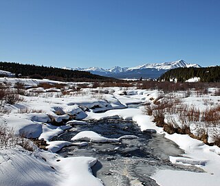
Bear Creek is a tributary of the Arkansas River and has its headwaters in Baca County, Colorado. [1] It flows through Baca County into Kansas and through Stanton and Grant Counties and into Kearny County where it converges with the Arkansas River about 8 miles southwest of Lakin, Kansas.

The Town of Crestone is a statutory town in Saguache County, Colorado, United States. The town population was 127 at the 2010 United States Census. It is a small village at the foot of the western slope of the Sangre de Cristo Range, in the northern part of the San Luis Valley. Crestone was a small mining town, but little paying ore was discovered. In the 1970s, a large land development, the Baca Grande, was established to the south and west where several hundred homes have been built.

Lincoln County is one of the 64 counties in the U.S. state of Colorado. As of the 2010 census, the population was 5,467. The county seat is Hugo. The county obtains its name in memory of President Abraham Lincoln.

Cheyenne County is the sixth-least densely populated of the 64 counties of the U.S. state of Colorado. The county population was 1,836 at 2010 census. The county seat is Cheyenne Wells.
Baca County is a county located in the U.S. state of Colorado. As of the 2010 census, the population was 3,788. The county seat is Springfield. It is located near the state borders with Kansas and Oklahoma.

The town of Two Buttes is a Statutory Town located in Baca County, Colorado, United States. The population was 43 at the 2010 census.

The Arkansas River is a major tributary of the Mississippi River. It generally flows to the east and southeast as it traverses the U.S. states of Colorado, Kansas, Oklahoma, and Arkansas. The river's source basin lies in the western United States in Colorado, specifically the Arkansas River Valley, where the headwaters derive from the snowpack in the Sawatch and Mosquito mountain ranges. It then flows east into the Midwest via Kansas, and finally into the South through Oklahoma and Arkansas.

The Cimarron River extends 698 miles (1,123 km) across New Mexico, Oklahoma, Colorado, and Kansas. The headwaters flow from Johnson Mesa west of Folsom in northeastern New Mexico. Much of the river's length lies in Oklahoma, where it either borders or passes through eleven counties. There are no major cities along its route. The river enters the Oklahoma Panhandle near Kenton, Oklahoma, crosses the southeastern corner of Colorado into Kansas, reenters the Oklahoma Panhandle, reenters Kansas, and finally returns to Oklahoma where it joins the Arkansas River at Keystone Reservoir west of Tulsa, Oklahoma, its only impoundment. The Cimarron drains a basin that encompasses about 18,927 square miles (49,020 km2).

Johnson Village is a small unincorporated community and census-designated place located in central Chaffee County, Colorado, in the United States. As of the 2010 census it had a population of 246.

The Salt Fork of the Arkansas River is a 239-mile-long (385 km) tributary of the Arkansas River in southern Kansas and northern Oklahoma in the United States. Via the Arkansas River, it is part of the watershed of the Mississippi River.

Coaldale is a census-designated place and U.S. post office in Fremont County, Colorado, United States. The population as of the 2010 census was 255. The Coaldale Post Office has the ZIP Code 81222.
Arapahoe County was a county of the extralegal United States Territory of Jefferson that existed from November 28, 1859, until February 28, 1861. The county name was also spelled Arapaho County, Arapahoe County, Arrapahoe County, and Arappahoe County. The county seat was Denver City.
Fountain County was a county of the extralegal United States Territory of Jefferson that existed from November 28, 1859, until February 28, 1861.
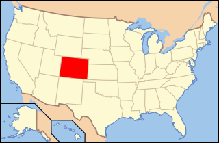
The following is an alphabetical list of articles related to the U.S. state of Colorado.

The following outline is provided as an overview of and topical guide to the U.S. state of Colorado:
North Fork Cimarron River is a 169-mile-long (272 km) tributary of the Cimarron River that flows from a source in Comanche National Grassland in Baca County, Colorado. It joins the Cimarron River west of Satanta in Haskell County, Kansas.

Treasure Mountain, elevation 13,535 ft (4,125 m), is a summit in the Elk Mountains of western Colorado. The mountain is in the Raggeds Wilderness southeast of Marble. The massif has been the site of marble mining and a legend of lost French gold.
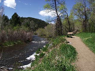
Bear Creek is a tributary of the South Platte River in central Colorado in the United States. Its source is Summit Lake near Mount Evans. The stream flows to a confluence with the South Platte River in Sheridan, Colorado, just south of Denver. Bear Creek runs through the Bear Creek Watershed. Bear Creek Watershed totals 236 square miles (610 km2), including all tributaries that discharge into the Bear Creek Reservoir. The two main tributaries are Bear Creek and Turkey Creek. The watershed extends from Mount Evans Wilderness to the Town of Morrison.
Tennessee Creek is a stream in Lake County, Colorado. It rises on the south side of Tennessee Pass near the Eagle County-Lake County line.
| This article related to a river in Kansas is a stub. You can help Wikipedia by expanding it. |
| This article related to a river in Colorado is a stub. You can help Wikipedia by expanding it. |

