P
- Pacific-type coastline
- See concordant coastline .
- padang
- An uncultivated, treeless grassland in Southeast Asia, sometimes swamp-like, supporting a scrubby heath-type vegetation common on leached sandy soils. [4]
- palisade
- 1. A wall of wooden stakes used as a defensive barrier.
- 2. A line of bold cliffs, especially one showing basaltic columns. [5]
- palsa
- An elliptical dome-like permafrost mound containing alternating layers of ice lenses and peat or mineral soil, commonly 3–10 metres (10–33 ft) high and 2–25 metres (7–82 ft) long, and occurring frequently in bogs in the Arctic and subarctic zones of discontinuous permafrost. [11]
- paludal
- Of or pertaining to a swamp or marsh, or to sediments that accumulate in a marshy environment. [9]
- pampa
- In parts of South America, a vast, fertile, grassy plain; or the temperate lowland region encompassing these plains.
- pan
- Any shallow, generally rounded basin or hollow, which may seasonally capture and hold water from rainfall or snowmelt, especially one occurring in an arid or semi-arid region; more specifically, the flat central part of such a depression, which may be temporarily or seasonally flooded. [4]
- panhandle
- See salient .
- panhole
- A rounded or circular depression eroded into flat or gently sloping cohesive rock, typically shallow and ranging in diameter from a few centimeters to several meters, that is capable of collecting and holding rainwater and snowmelt. The term is sometimes used interchangeably with pothole, though the latter may also refer to distinct geological features.
- pantanal
- In southern Brazil, a wetland region consisting of a usually dry savanna that is seasonally flooded by a river. [4]
- pantograph
- An instrument that enables the mechanical copying of a map or technical drawing on a selectable scale, such that the movement of one pen, in tracing an image, produces identical movements in a second pen, resulting in a duplicate image that is the same size, enlarged, or miniaturized with respect to the original. Pantographs typically consist of hinged rods arranged in the shape of a parallelogram which rotate about a fixed point. [4]
- parallel
- 1. (geometry) Extending in the same direction, equidistant at all points, and never converging or diverging; having the same orientation, nature, tendency, or course; corresponding or similar.
- 2. (geography) Another name for a circle of latitude.
- parish
- A type of subnational division of a country or federal state used for religious, administrative, or other purposes.
- park
- pass
- See mountain pass .
- passive glacier
- A glacier with low rates of both alimentation and ablation because it receives only light snowfall and undergoes little melting throughout the year. Such glaciers move very slowly and transport relatively small amounts of ice and debris. [4] Contrast active glacier .
- pasture
- Any land used for grazing by livestock, often a natural grassland supporting native grasses and forbs with little or no active management by humans, as opposed to a meadow, where the vegetation is mown for hay or silage. [4]
- peak
- 1. A pointed or protruding top or vertical projection on a landform, e.g. a mountain, especially implying the highest point or elevational maximum, i.e. the summit. [4]
- 2. A mountain as a whole, in particular a high, isolated, or prominent one.
- pediment
- An eroded, often bare rock platform, cut into the local bedrock, usually slightly concave and triangular in shape and extending over a considerable area at the foot of an abrupt mountain slope or face, the lower edge sloping gently away. Pediments form basal slopes of transport for weathered material derived from the steeper slope above, and are characteristic of arid and semi-arid lands. [4]
- pediplain
- pedology
- The scientific study of the morphology, composition, and spatial distribution of soils, with an emphasis on classifying soils and understanding their formation and evolution. [4]
- pedosphere
- pelagic zone
- peneplain
- A low-relief plain leveled by long-term erosion, often implying a landscape that is in the final stages of fluvial erosion during an extended period of tectonic stability, i.e. approaching the point at which all initial topographic inequalities such as mountains and hills have been eroded and evenly redistributed into a broad, flat, uniform surface at or near sea level.
- peninsula
- A piece of land surrounded by water along the majority of its border while still being connected to a mainland from which it projects.
- perched water table
- perennial stream
- A stream that normally flows continuously throughout the entire year, without drying up, as opposed to a transient or intermittent stream.
- pericline
- periglacial
- 1. Of or relating to an area located adjacent to or on the margin of an ice sheet or glacier, either presently or in the past; or to associated phenomena. [4]
- 2. Any place where seasonal cycles of freezing and thawing modify the landscape in a significant manner.
- periplus
- A historical manuscript listing the ports, safe anchorages, and coastal landmarks that a maritime vessel could expect to encounter along a shore or coastline, arranged in order according to a particular direction of travel and including the intervening distances between them. See also itinerarium .
- permafrost
- A permanently frozen layer of soil; [5] permanently frozen ground at high latitude and high elevation. [12]
- petrographic province
- photic zone
- The uppermost layer of a body of water (e.g. a lake or ocean), defined by the maximum depth to which sunlight can penetrate the water column. The photic zone usually supports large populations of photosynthetic organisms and the majority of the aquatic life inhabiting the body as a whole.
- photogrammetry
- 1. The science and technology of obtaining reliable information about physical objects and environments through the process of recording, measuring, and interpreting photographic images (usually aerial or orbital ones) and patterns of electromagnetic radiant imagery and other phenomena.
- 2. The science of extracting three-dimensional measurements from two-dimensional data, such as images.
- phreatic water
- See groundwater .
- phreatic zone
- The part of an aquifer that is below the water table, where nearly all pores and fractures are fully saturated with water. Contrast vadose zone .
- physical geography
- The branch of geography that studies processes and patterns in the natural environment, such as the atmosphere, hydrosphere, geosphere, and biosphere, as opposed to the cultural or built environment. Along with human geography, it is one of the two major sub-fields of geography.
- physiographic region
- A portion of the Earth's surface with a common topography and morphology. [5]
- physiography
- Another name for physical geography. [5]
- piedmont
- Any geographic region lying or formed at the base of mountains. The term is used primarily in the southeastern United States to refer to a broad region extending from the Blue Ridge Mountains to the Atlantic coastal plain. [5]
- piezometric surface
- pingo
- A periglacial landform consisting of a relatively large conical mound of soil-covered ice, commonly 30–50 metres (100–160 ft) high and up to 1,000 metres (0.6 mi) in diameter, and that grows and persists in part as a result of hydrostatic pressure within and below the permafrost of Arctic and subarctic regions. [11]
- pinnacle
- Any natural, free-standing, vertical or nearly vertical column of earth or rock in the shape of a tall, often slender shaft or spire, and which is distinguished by its isolation from nearby rocks or other landforms. The term is applied to a wide variety of geological formations of various sizes and has numerous regional and local synonyms with which it may be used more or less interchangeably. See also demoiselle , hoodoo , prominence , stack , and zeuge .
- pit crater
- A type of crater formed by the sinking or collapse of the surface lying above a void or empty chamber. Pit craters are similar to calderas and are often associated with volcanic activity, but lack the ejecta deposits and lava flows of volcanic craters.
- place
- A particular point on the Earth's surface, or the area surrounding such a point, having or encompassing a definite position; a location, often specifically named, that is identifiable in social interaction because humans have endowed it with meaning or purpose; [13] a mental representation of a physical space created from functional or emotional associations in the human mind. The concept of place – how places are created, identified, mapped, connected, and used – is fundamental to many aspects of geography.
- place identity
- place utility
- The measure of approval or satisfaction accorded by an individual to a location in his or her action space; the value or usefulness of a particular place as perceived by a particular person. Dissatisfaction with place utility may result in migration. [4]
- placename
- See toponym .
- placer
- 1. (mineral deposit) An accumulation of valuable minerals, particularly gold, formed by gravity separation from a source rock during natural sedimentary processes. The minerals, weathered from rocks or veins, are washed out by streams and mixed with alluvial deposits of sand or gravel, from which they can then be extracted by placer mining.
- 2. (reef) A flat, shallow sandbank or reef submerged beneath the ocean surface, often with a sandy bottom suitable as an anchorage for seagoing vessels.
- plain
- Any broad, flat expanse of land that generally does not show significant variation in topography or elevation.
- plane table
- A small drawing board mounted on a tripod used in surveying, site mapping, and related disciplines to provide a solid and level surface upon which to make drawings, charts, and maps while in the field.
- planimetric map
- A map which uses a two-dimensional coordinate system, i.e. in which each point is represented by only two coordinates (x, y), as if all of the depicted features existed within a single, flat plane. These maps usually exclude information about vertical position and therefore do not show topographic relief and represent only horizontal distances. [14]
- plat
- A cadastral map, drawn to scale, showing the legal boundaries and divisions of a surveyed tract of land, particularly of the type used to divide real property for sale and settlement in the Public Land Survey System of the United States. [14]
- plate tectonics
- A geologic theory that the bending (folding) and breaking (faulting) of the solid surface of the Earth results from the slow movement of large sections of that surface called plates. [5]
- plateau
- A large area of relatively flat terrain that is significantly higher in elevation than the surrounding landscape, often with one or more sides with steep slopes.
- platted land
- Land that has been divided into surveyed lots. [5]
- playa
- An exceptionally flat, arid basin that is the dry bed of an evaporated lake; or the shallow, usually saline lake itself which periodically forms when the basin is temporarily covered with water, e.g. after substantial rainfall. See also salt pan .
- plucking
- An erosional phenomenon whereby a glacier gradually scours and displaces pieces of rock from the bedrock beneath it and transports them along with the glacial flow of ice and debris. As the glacier moves down a valley, friction causes the basal ice to melt and infiltrate joints and cracks in the bedrock; repeated freezing and thawing widens and deepens these cracks, eventually loosening the rock and causing large blocks and boulders to be carried along by the overlying ice. These boulders are often deposited hundreds of kilometers from their source, becoming erratics. The term is also sometimes used to describe the similar process of quarrying, which occurs on a smaller scale in fast-moving rivers and streams. [4]
- plug
- A cylindrical mass of volcanic rock marking the neck of an ancient volcano, especially one exposed by denudation of the surrounding cone. [4]
- plumb line
- A vertical reference line created by suspending a weight, known as a plumb bob or plummet, from a string above the Earth's surface and allowing it to hang freely in the direction of the pull of gravity. A precursor to the spirit level, plumb lines are used to establish a vertical datum in a wide range of applications, particularly in surveying to determine the nadir of a point in space, and often in combination with an instrument to set the instrument precisely over a fixed survey marker.
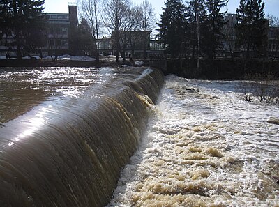
- plunge pool
- A deep depression at the base of a waterfall into which the water drops with great force, plucking and abrading the rock beneath and behind the falls and creating an often nearly circular concavity which may remain filled with water long after the waterfall itself dries up. [4]
- plural society
- A situation in which two or more culture groups occupy the same territory but maintain their separate cultural identities. [5]
- point bar
- A depositional feature made of alluvium that accumulates on the inside bend of a meandering stream or river, below the slip-off slope and often directly opposite a cut bank. Point bars are usually crescent-shaped beaches of sand, silt, or gravel, similar to shoals and river islands.
- polar aspect
- A planar map projection with its origin located at either the North or the South geographic pole. [14]
- polar circle
- Either of the two circles of latitude enclosing the Earth's polar regions: the Arctic Circle in the Northern Hemisphere and the Antarctic Circle in the Southern Hemisphere.
- polar ice cap
- Either of the two very large regions near the Earth's geographical poles that are seasonally or persistently covered in ice, which occurs because high-latitude regions receive less direct solar radiation than other regions and therefore experience much lower surface temperatures. The Earth's polar ice may cover both land and sea, and varies in size seasonally and with long-term climate change. They typically cover a much larger area than true ice caps and are more correctly termed ice sheets.
- polar region
- Either of the two high-latitude regions surrounding the Earth's geographical poles (the North and South Poles), which are characterized by frigid climates and extensive polar ice caps. The polar region of the Northern Hemisphere is often simply called the Arctic and that of the Southern Hemisphere is called the Antarctic.
- polder
- A low-lying tract of land enclosed by dikes, forming an artificial hydrological entity by creating land from a naturally inundated area, e.g. by reclaiming land from a lake or sea, or by building barriers around a floodplain or marsh and then draining it. All polders are eventually below the surrounding water table some or all of the time, making them especially prone to flooding, and they often require continuous draining.
- pole
- 1. An extreme geographical point, especially one of a pair.
- 2. Either of the two points where the Earth's axis of rotation meets its surface, i.e. the geographic poles, representing the northern and southern extremities of terrestrial latitude: the Geographic North Pole and the Geographic South Pole.
- 3. Either of the two ends of the geomagnetic field generated by the dynamo in the Earth's core. These ends may refer either to the true magnetic poles, known as the Magnetic North Pole and the Magnetic South Pole, which are not directly opposite each other, or to the antipodal poles of a hypothetical perfect dipole passing through the Earth's center, known as the Geomagnetic North Pole and the Geomagnetic South Pole.
- pole of inaccessibility
- A location that, with respect to a given geographical criterion, is the most difficult to reach according to that criterion, e.g. the geographical location that is the most distant from the nearest point meeting that criterion. The term most commonly refers to the so-called continental or oceanic poles of inaccessibility, i.e. the point on a given continental landmass that is the furthest distance from a coastline, and the point in the ocean that is the furthest distance from land, respectively.
- political geography
- The study of both the spatially uneven outcomes of political processes and the ways in which political processes are themselves affected by spatial structures. A sub-discipline of human geography, its primary concerns can be summarized as the relationships between people, state, and territory.
- polje
- A very large plain found in karstic regions, enclosed within a depression, usually elliptical, with a flat floor either of bare limestone or covered by alluvium, and generally surrounded by steep limestone walls; or more broadly any enclosed or nearly enclosed valley. The term is used primarily in the Slavic-speaking world.
- polynodal
- Many-centered; having many nodes. [5]
- polynya
- An area of unfrozen seawater surrounded by an otherwise contiguous area of pack ice or fast ice. Polynyas are often formed along polar coastlines through the action of katabatic winds, but may also form in the open ocean.
- pond
- A natural or artificial body of standing water that is usually smaller than a lake.
- populated place
- A place or area with clustered or scattered buildings and a permanent human population (a city, settlement, town, or village) that is referenced with geographic coordinates. [12]
- population
- A collection of organisms of the same group or species which live in a particular geographical area. In the context of geography, it often refers to a collection of humans and is represented at the most basic level as the number of people in a given geographically or politically defined space, such as a city, town, region, country, or the entire world.
- population geography
- A branch of human geography that studies the ways in which spatial variations in the composition, distribution, migration, and growth of populations are related to the nature of places. This often involves factors such as where populations are found and how the size and composition of these populations is regulated by the demographic processes of fertility, mortality, and migration.
- positional error
- The amount by which the mapped location of an imaged cartographic feature fails to agree with the feature's actual location in the real world. [2]
- positioning system
- Any technology or mechanism used to determine the position of an object in space. Numerous methods for determining position have been practiced since ancient times, though modern positioning systems generally rely on electromagnetic and/or satellite-based technologies capable of providing coverage ranging from local or regional to global and accuracy ranging from tens of metres to sub-millimetre.
- post-industrial
- An economy that gains its basic character from economic activities developed primarily after manufacturing grew to predominance. Most notable would be quaternary economic patterns. [5]
- potamology
- The branch of hydrology that studies rivers, including the processes and phenomena that occur at their sources, main channels, and mouths; the structure and morphology of drainage basins; and the water, thermal, ice, and sediment regimes that affect and are affected by river discharge.
- potentiometric surface
- See piezometric surface .
- pothole
- 1. Any smooth, bowl-shaped or cylindrical hollow, generally deeper than it is wide, that is carved into the rocky bed of a watercourse such as a stream or river. Fluvial potholes are created by the grinding action of stones or coarse sediment kept in perpetual motion in the same spot by the turbulence of the current. The term is also used to refer to plunge pools beneath waterfalls, which are created by similar processes. See also kolk .
- 2. A vertical or steeply inclined karstic shaft in a limestone deposit.
- 3. In the Great Plains of North America, a shallow depression, generally less than 10 acres (4.0 ha) in area, occurring between dunes or on morainic relief on a prairie and often filled by an intermittent pond or marsh.
- 4. Another name for a kettle.
- 5. Another name for a panhole.
- prairie
- A type of temperate grassland ecosystem dominated by a characteristic composition of grasses, herbs, and shrubs, rather than by trees. The term is used primarily in North America, but similar ecosystems can be found across the world.
- Precambrian rock
- The oldest rocks, generally more than 600 million years old. [5]
- presque-isle
- A peninsula connected to the mainland by an extremely narrow neck of land such that the land at its distal end is very close to being an island. See also tied island .
- prevailing winds
- The direction from which winds most frequently blow at a specific geographic location. [12]
- primary sector
- That portion of a region's economy devoted to the extraction of basic materials (e.g., mining, lumbering, agriculture). [5]
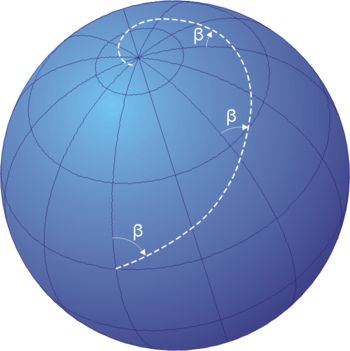
- Prime Meridian
- The imaginary line running from north to south through the Royal Observatory in Greenwich, England which is assigned a longitude of 0 degrees and is therefore used as the reference point for all other lines of longitude. [6]
- proglacial
- Preceding, in advance of, or in front of the toe or moraine of a glacier, either spatially or temporally. [4]
- progradation
- The natural extension of a shoreline into a body of water by the gradual accumulation of sediment over time, [15] especially as a result of fluvial sedimentation processes, such as the protrusion of a river delta into the sea. This occurs when the volume of sediment carried by the river and deposited at its mouth exceeds the volume lost through subsidence, sea level rise, or coastal erosion.
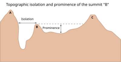
- prominence
- 1. A conspicuous high point that projects above or beyond its surroundings, e.g. a butte or a promontory. [9]
- 2. See topographic prominence .
- promontory
- A raised mass of land that projects into a lowland or a body of water. Compare headland and cape .
- protected area
- Any clearly defined geographic space in which human occupation or the exploitation of resources is limited or forbidden through legal or other effective means because of the area's recognized natural, ecological, cultural, or historical value.
- province
- A type of second-level administrative division within a country or federal state.
- psychogeography
- public land
- Any land area held and managed in the public domain by a federal or local government.
- pueblo
- A type of Indian village constructed by some tribes in the southwestern United States. A large community dwelling, divided into many rooms, up to five stories high, and usually made of adobe. This is also a Spanish word for town or village. [5]
- puna
- An ecoregion in the central Andes Mountains of South America, or any of the various high-altitude ecosystems encompassing it, including cold deserts and alpine grasslands.
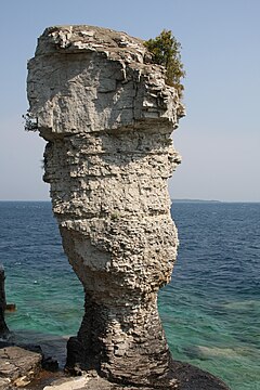

Rock spires or pinnacles may range in size from small pillars a few metres tall to entire mountains stretching thousands of metres from base to summit. Left: Large Flowerpot on Flowerpot Island, Ontario, Canada; 12 metres (39 ft). Right: Southeast face of Cerro Torre, border of Chile and Argentina; 2,100 metres (6,900 ft).