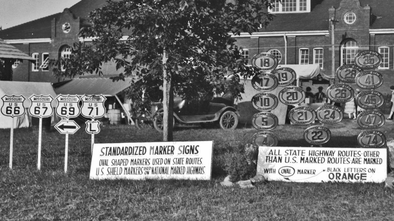
The old cut-out style markers once used in Missouri. From 1922 until 1931, the Missouri Highway System was marked with oval cast iron markers with an orange background and black lettering.
This is a list of former highways as assigned in 1922. All numbers from Route 1 to Route 72 were issued. From Route 72 to Route 98, only even numbers were issued.
In 1926, the U.S. Highway System was created and many of the highways listed below became part of a new U.S. Highway; in some cases, a highway's number was changed so as not to conflict with a U.S. Highway number (or, later, an Interstate Highway number) which came through Missouri.
Route 1 , Arkansas to Iowa via Kansas City: still exists near Kansas City Route 1A , Rock Port to Phelps City: became US 136 Route 1B , branch to Craig: not built, since Route 1 (US 59) was routed through Craig Route 1C , Mound City to Bigelow: became Route 118 Route 1D , Mound City to Skidmore: became Route 113 Route 1E , branch to New Point: became Route 120 Route 1F , Oregon to Forest City: became Route 111 Route 1F , Joplin to Kansas: became US 66 Route 2 , Kansas City to St. Louis via Columbia: became US 40 Route 3 , Arkansas to Iowa via Springfield: became US 65 Route 4 , St. Joseph to Alexandria: became US 136 Route 4A , Albany to Evona: became Route 85 Route 5 , Arkansas to Iowa via Boonville: still exists Route 5A , Wasola to Longrun: became Route 95 Route 6 , St. Joseph to Canton: still exists Route 7 , Arkansas to Iowa via Jefferson City: became US 63 Route 8 , St. Joseph to Hannibal: became US 36 Route 9 , Arkansas to Iowa via St. Louis: became US 61 and Route 4B, which became Route 81 Route 9A , Palmyra to Philadelphia: became Route 56; became Route 168 US 56 came into the state Route 10 , Kansas City to Monroe City: still exists west of Carrollton Route 11 , Kansas City to Iowa: became US 69 Route 12 , Kansas City to St. Louis via Jefferson City: became US 50 Route 12A , California to Jamestown: became Route 87 Route 12B , Linn to Chamois: became Route 89 Route 13 , Bolivar to Gallatin: still exists Route 14 , Carthage to St. Louis: became US 66 Route 15 , Buffalo to Iowa via Jefferson City: still exists north of Mexico Route 16 , Oklahoma to Kentucky via Springfield: became US 60 Route 17 , Mountain View to Eugene: still exists [ 4] Route 18 , Tarkio to Stanberry: became US 136 Route 19 , Thayer to Cuba: still exists Route 20 , Kansas City to Huntsville: still exists (realigned) west of Marshall Route 21 , Arkansas to De Soto: still exists Route 22 , Clark to Illinois: still exists west of Mexico Route 23 , Arkansas to Fredericktown: became US 67 Route 24 , Kansas to Tuscumbia: became Route 52 Route 25 , Arkansas to Festus: still exists south of Jackson Route 26 , Kansas to Osceola: became Route 62; became Route 82 when US 62 came into the state Route 27 , Savannah to Iowa: became US 71 and Route 148 Route 28 , Waynesville to Rosebud: still exists Route 29 , Stanberry to Iowa: became US 169 Route 30 , St. Clair to St. Louis: still exists Route 31 , Clarksdale to King City: still exists Route 32 , Licking to Flat River: still exists Route 33 , Kansas City to Osborn: still exists Route 33A , Plattsburg to Lathrop: became Route 116 Route 34 , Garwood to Jackson: still exists Route 35 , Harrisonville to Kansas City: swapped with US 71 and later became Route 291 Route 36 , Kansas to Springfield: became US 160 Route 37 , Arkansas to Monett: still exists Route 38 , Carthage to Republic: became Route 14 and later became US 166 Route 39 , Pennsboro to Stockton: still exists Route 40 , Billings to near West Plains: became Route 14 Route 41 , Lamine to De Witt: still exists Route 42 , Alton to Poplar Bluff: became Route 14 and later became US 160 Route 43 , Arkansas to Marionville: became Route 13 Route 44 , Anderson to Spokane: became Route 76 Route 45 , Drake to Martinsburg: became Route 19 Route 46 , through Grant City: still exists Route 47 , Villa Ridge to Troy: still exists Route 48 , Rosendale to King City: still exists Route 49 , Piedmont to Glover: still exists Route 50 , St. Joseph to Grayson: became US 169 Route 51 , Advance to Illinois: still exists Route 51A , Dongola to Puxico: became Route 51 Route 52 , Kansas to St. Joseph: became US 59 Route 52A , branch to Lewis and Clark Lake: became Route 45 Route 53 , Kennett to Poplar Bluff: still exists Route 54 , Paris to New London: became Route 26; now Routes 154 and 19 Route 54A , Perry to Hutchison: became Route 19 Route 55 , Wolf Island to Benton: became Route 77 Route 55A , Charleston to East Prairie: became Route 105 Route 56 , Troy to O'Fallon: became Routes 47 and 79 Route 57 , Webb City to Kansas: became Route 171 Route 58 , Pleasant Hill to Warrensburg: still exists Route 59 , Kansas City to Platte City: became Route 9 Route 60 , Leeton to Windsor: became Route 2 Route 61 , Tarkio to Iowa: became Route 9 and later became US 59 Route 62 , Steelville to Potosi: became Route 8 Route 63 , Harrisonville to Lees Summit: became Route 7 Route 64 , Collins to Preston: still exists east of Hermitage Route 64A , Wheatland to Quincy: became Route 83 Route 65 , St. James to Hawkins Store: became Route 68 Route 66 , El Dorado Springs to Fair Play: became US 54; now Route 32 Route 67 , Rocheport to Fayette: became Route 3; now Route 240 Route 68 , Farmington to Sainte Genevieve: became Route 32 Route 69 , Springfield to Bolivar: became Route 13 Route 70 , Ironton to Fredericktown: became Route 72 Route 71 , Springfield to Preston: absorbed by Route 3 (US 65) when its portion here was not built Route 72 , Salem to Centerville: still exists Route 74 , Dutchtown to Cape Girardeau: still exists Route 76 , Spokane to Forsyth: swapped with Route 80 (now US 160); still exists Route 78 , Branson to Brownbranch: became Route 76 and Route 80 (this section later became part of Route 76) Route 80 , Gainesville to West Plains: became US 160 Route 82 , Malden to New Madrid: became US 62 Route 84 , Arkansas to Caruthersville: still exists Route 86 , Blue Eye to Hollister: still exists Route 88 , Lanagan to Arkansas: became US 71 when Route 59 was formed Route 90 , Oklahoma to Noel: still exists Route 92 , Kansas to Smithville: still exists Route 94 , St. Charles to West Alton: still exists [ 5] Route 96 , Odessa to Marshall: not built, but now partly Route 20 Route 98 , Boonville to Overton: still exists This page is based on this
Wikipedia article Text is available under the
CC BY-SA 4.0 license; additional terms may apply.
Images, videos and audio are available under their respective licenses.


