| North Fork Snake River [1] | |
|---|---|
| Physical characteristics | |
| Source | |
| ⁃ location | Summit County, Colorado |
| ⁃ coordinates | 39°39′45″N105°52′17″W / 39.66250°N 105.87139°W |
| Mouth | |
⁃ location | Confluence with Snake |
⁃ coordinates | 39°36′18″N105°56′31″W / 39.60500°N 105.94194°W Coordinates: 39°36′18″N105°56′31″W / 39.60500°N 105.94194°W |
⁃ elevation | 9,350 ft (2,850 m) |
| Basin features | |
| Progression | Snake—Blue—Colorado |
| Waterfalls | Snake River Falls |
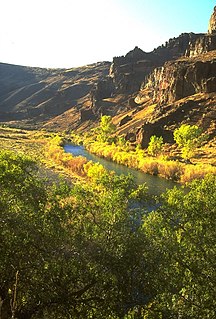
The North Fork Snake River is a tributary of the Snake River in central Colorado in the United States. It flows from a source near Loveland Pass to a confluence with the Snake River in Keystone. Pass Lake is a secondary source of the river.

Roaring Fork River is a tributary of the Colorado River, approximately 70 miles (110 km) long, in west central Colorado in the United States. The river drains a populated and economically vital area of the Colorado Western Slope called the Roaring Fork Valley or Roaring Fork Watershed, which includes the resort city of Aspen and the resorts of Aspen/Snowmass.

The Crystal River is a tributary of the Roaring Fork River, approximately 40 mi (64 km) long, in western Colorado in the United States. It drains a glacial valley, called the Coal Basin, south of Carbondale which was historically known as a center of coal mining in southwestern Colorado. It rises in northern Gunnison County in the Elk Mountains on the north side of Schofield Pass, passing through the ghost town of Crystal City, still inhabited by a few summer residents. It then flows north past Marble, then into Pitkin County past Redstone. It joins the Roaring Fork below Carbondale. State Highway 133 follows the river along much of its route north of Marble.
The Owyhee River is a tributary of the Snake River located in northern Nevada, southwestern Idaho and southeastern Oregon in the United States. It is 280 miles (450 km) long. The river's drainage basin is 11,049 square miles (28,620 km2) in area, one of the largest subbasins of the Columbia Basin. The mean annual discharge is 995 cubic feet per second (28.2 m3/s), with a maximum of 50,000 cu ft/s (1,400 m3/s) recorded in 1993 and a minimum of 42 cu ft/s (1.2 m3/s) in 1954.

Henrys Fork is a tributary river of the Snake River, approximately 127 miles (204 km) long, in southeastern Idaho in the United States. It is also referred to as the North Fork of the Snake River. Its drainage basin is 3,212 square miles (8,320 km2), including its main tributary, the Teton River. Its mean annual discharge, as measured at river mile 9.2 by the United States Geological Survey (USGS), is 2,096 cubic feet per second (59.4 m3/s), with a maximum daily recorded flow of 79,000 cubic feet per second (2,240 m3/s), and a minimum of 183 cubic feet per second (5.18 m3/s).

The Middle Fork Willamette River is one of several forks that unite to form the Willamette River in the western part of the U.S. state of Oregon. It is approximately 115 miles (185 km) long, draining an area of the Cascade Range southeast of Eugene, which is at the southern end of the Willamette Valley.

The Burnt River is a 98-mile-long (158 km) tributary of the Snake River in eastern Oregon, United States. It enters the Snake near Huntington, Oregon, at a point upstream of the Powder River and downstream of the Malheur River, slightly more than 327 miles (526 km) from the Snake's confluence with the Columbia River. Draining 1,090 square miles (2,800 km2), it flows predominantly west to east.

South Fork Eagle River is a 6.9-mile-long (11.1 km) tributary of the Eagle River in Eagle County, Colorado. The river flows from a source east of Tennessee Pass in the White River National Forest to a confluence with the East Fork Eagle River that forms the Eagle River.
North Fork Little Snake River is a 13.1-mile-long (21.1 km) tributary of the Little Snake River in Colorado and Wyoming. It flows from a source in the Medicine Bow National Forest of Carbon County, Wyoming to a confluence with the Middle Fork Little Snake River in Routt County, Colorado that forms the Little Snake River.
Middle Fork Little Snake River is a 17.5-mile-long (28.2 km) tributary of the Little Snake River in Routt County, Colorado. It flows from a source near the Continental Divide in Routt National Forest to a confluence with the North Fork Little Snake River that forms the Little Snake River.
South Fork Little Snake River is an 18.2-mile-long (29.3 km) tributary of the Little Snake River in Routt County, Colorado. It flows north from a source in Routt National Forest near Steamboat Lake State Park to a confluence with the Little Snake River.
Roaring Fork Little Snake River is a 12.0-mile-long (19.3 km) tributary of the Little Snake River in Colorado and Wyoming. It flows from a source in the Medicine Bow National Forest of Carbon County, Wyoming to a confluence with the Little Snake River in Routt County, Colorado.

The Williams Fork is a tributary of the Colorado River, approximately 33.8 miles (54.4 km) long, in north central Colorado in the United States. It flows through Grand County between the valleys of the Fraser River and the Blue River. It rises at the juncture of McQueary and Bobtail creeks just west of the Continental Divide 8 miles (13 km) west of Berthoud Pass and 7 miles (11 km) north of the Eisenhower Tunnel in the Arapaho National Forest. It flows north-northwest to the Williams Fork Reservoir, then turns northeast and joins the Colorado at Parshall.

South Fork Rio Grande is a tributary of the Rio Grande in southern Colorado in the United States. It flows from a source in the Weminuche Wilderness of the San Juan Mountains to a confluence with the Rio Grande at the town of South Fork in Rio Grande County, Colorado.
South Fork Swan River is a tributary of the Swan RIver in Summit County, Colorado. The stream flows northwest from a source near Georgia Pass in the Arapaho National Forest to a confluence with the Middle Fork Swan River that forms the Swan River.
North Fork West Mancos River is a tributary of the West Mancos River in Montezuma County, Colorado. The river flows from a source east of Hesperus Mountain in the San Juan National Forest to a confluence with the South Fork that forms the West Mancos River.

The North Fork Owyhee River is a tributary, about 30 miles (48 km) long, of the Owyhee River in Malheur County, Oregon, and Owyhee County, Idaho, in the United States. It begins on the east flank of the Owyhee Mountains in Idaho and flows generally southwest to meet the main stem at Three Forks, Oregon, 161 miles (259 km) above the confluence of the larger river with the Snake River.
The Middle Fork Owyhee River is a tributary of the North Fork Owyhee River in Malheur County, Oregon, and Owyhee County, Idaho, in the United States. It forms along Juniper Mountain, south of the Owyhee Mountains in Idaho. From its headwaters, it flows southwest then curves northwest to and beyond the Idaho–Oregon border, then turns north to meet the North Fork at Three Forks, Oregon. The confluence is less than a mile upstream from the North Fork's confluence with the Owyhee River. Below Three Forks, the main stem Owyhee flows 161 miles (259 km) to empty into the Snake River.
| This article related to a river in Colorado is a stub. You can help Wikipedia by expanding it. |
