Sangareddy

Last updated

Sangareddy
Sangareddipet
SRDcollectorate.jpg
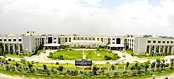
Collectorate building of Sangareddy
India Telangana location map.svg
Red pog.svg
Sangareddy
Location in Telangana, India
India location map.svg
Red pog.svg
Sangareddy
Sangareddy (India)
Coordinates: 17°37′46″N78°05′30″E / 17.6294°N 78.0917°E / 17.6294; 78.0917
Country Flag of India.svg  India
State Telangana
District Sangareddy
Metro Hyderabad Metropolitan Region
CityHyderabad
Municipal Established1954
(70 years ago)
 (1954)
Named for Sanga
Government
  Type Municipal Council
  BodySangareddy Municipal Corporation
   MLA Chinta Prabhakar
   District collector Smt .Valluru Kranthi, IAS
Area
[1]
   City 13.70 km2 (5.29 sq mi)
Elevation
496 m (1,627 ft)
Population
 (2011) [1]
   City 72,344
  Rank 21st in Telangana
  Density5,300/km2 (14,000/sq mi)
   Metro
325,000
Languages
  Official Telugu, Urdu
Time zone UTC+5:30 (IST)
PIN
502 001
Telephone codecode-08455
Vehicle registration TS 15

Sangareddy, formally Sangareddipet [2] is a city and district headquarters of the Sangareddy district in the Indian state of Telangana. It was named after the ruler Sanga, who was the son of Rani Shankaramba, a ruler of Medak during the Nizam era. It is the largest city in the Sangareddy district and the sixth largest city in the state.

Contents

Government and politics

Civic administration

The Sangareddy Municipality, classified as a first grade municipality with 38 election wards, was created in 1954. The jurisdiction of the civic body is spread over an area of 13.69 km2 (5.29 sq mi). [1] The city is spread over an urban area of 45 km2 (17 sq mi).

Economy

The city has three large-scale public sector industries. These are Bharat Heavy Electricals Limited (one of the Maharatna companies of the Indian government), Bharat Dynamics Limited (where one of India's most powerful missiles, Prithvi, was produced), and Ordnance Factory Medak (which manufactures the Sarath tanks for the Indian Army).

The city includes the Old Sangareddy and New Sangareddy sections. Old Sangareddy is known for its bazaars and old district jail, which has been converted to a jail museum and now called Heritage Jail Museum. [3]

Monin, a French liquor company, has started to build a manufacturing facility in the district. [4]

Education

There are a variety of educational institutions in Sangareddy. There is a Government Medical College, Sangareddy.

Transportation

Roads

NH-65 road passes through the city.

About 15 km away from Sangareddy is an outer ring road which connects to Shamshabad airport – Rajiv Gandhi International Airport, Hyderabad, Gachibowli, and Medchal.

A bypass road to NH44 is linked from Sangareddy to Shadnagar through Chevella.

Long distance travel options are also available from Sangareddy to Tirupati, Vizag, Vijayawada, and Kandukooru directly.

Rail

The nearest railway stations are Shankarpalli railway station which is about 22 km away, Lingampally, which is about 30 km away, Secunderabad (about 50 km away) and Nampally Station, which is around 53 km away. Zahirabad Railway Station which is about 55 km away.

Air

The nearest air transport facility is Hyderabad International Airport, which is 70 km from Sangareddy.

Demographics

Religion in Sangareddy [5]

   Hinduism (62.4%)
   Islam (34.4%)
   Christianity (1.8%)
  Others (1.4%)

The city had a population of 72,344 as of the 2011 census. [6] [7]

Media

The Telugu dailies publishers in the city are Eenadu , Andhra Jyothy, and Sakshi. Apart from the local language, there are also English papers such as The Hindu , The Times of India , and The Hans India .

Notable people

Related Research Articles

<span class="mw-page-title-main">Karimnagar</span> City in Telangana, India

Karimnagar is also known as Elagandula is a city and District Headquarters in the Indian state of Telangana. Karimnagar is a major urban agglomeration and third largest city in the state. It is governed by the Municipal Corporation and is the headquarters of the Karimnagar district It is situated on the banks of Manair River, which is a tributary of the Godavari River. It is the third largest and fastest growing urban settlement in the state, according to 2011 census. It has registered a population growth rate of 45.46% and 38.87% respectively over the past two decades between 1991 and 2011, which is highest growth rate among major cities of Telangana. It serves as a major educational and health hub for the northern districts of Telangana. It is a major business center and widely known for its agricultural and granite industries, earning the nickname "City of Granites."

<span class="mw-page-title-main">Telangana</span> State in southern India

Telangana is a state in India situated in southern part of the Indian peninsula on the high Deccan Plateau. It is the eleventh-largest state and the twelfth-most populated state in India as per 2011 census. On 2 June 2014, the area was separated from the northwestern part of United Andhra Pradesh as the newly formed state of Telangana, with Hyderabad as its capital.

<span class="mw-page-title-main">Rajahmundry</span> District Headquarter in Andhra Pradesh, India

Rajahmundry, officially known as Rajamahendravaram, is a city in the Indian state of Andhra Pradesh and district headquarters of East Godavari district. It is the fifth most populated city in the state. During British rule, the district of Rajahmundry was created in the Madras Presidency in 1823. It was reorganised in 1859 and bifurcated into the Godavari and Krishna districts. Rajahmundry was the headquarters of Godavari district, which was further bifurcated into East Godavari and West Godavari districts in 1925. When the Godavari district was bifurcated, Kakinada became the headquarters of East Godavari and Eluru the headquarters of West Godavari. It is administered under Rajahmundry revenue division of the East Godavari district. The city is known for its floriculture, history, culture, agriculture, economy, tourism, and its heritage. It is known as the "Cultural Capital of Andhra Pradesh".

<span class="mw-page-title-main">Kothagudem</span> City in Telangana, India

Kothagudem is a city in Telangana. It serves as the headquarters of the Bhadradri Kothagudem district of the Indian state of Telangana. It was a portion of large Zamindari estate known as Husanabad Shankaragiri or Palvancha Zamindari in the Nizam's Dominion. Estate name was given by Captain Glasfurd. The Zamindar of Bhadrachalam was Zamindar of Palvancha also.

<span class="mw-page-title-main">Nizamabad, Telangana</span> City in Telangana, India

Nizamabad, also known as Induru, is a city in the Indian state of Telangana. It is governed by municipal corporation and is the headquarters of the Nizamabad district. Although previously part of Hyderabad State and then Andhra Pradesh state, Nizamabad became a part of the newly formed state of Telangana by the Andhra Pradesh Reorganisation Act, 2014. It is located about 186 kilometres (116 mi) north of the state capital, Hyderabad.

<span class="mw-page-title-main">Adilabad</span> City in Telangana, India

Adilabad is a city which serves as the headquarters of Adilabad district, in the Indian state of Telangana. Telugu, Urdu, Marathi, and Lambadi, gondi are the most spoken languages of Adilabad. Adilabad is famous for its rich cultivation of cotton. Hence, Adilabad is also referred as "White Gold City". It is located about 304 kilometres (189 mi) north of the state capital, Hyderabad, 150 kilometres (93 mi) from Nizamabad and 196 kilometres (122 mi) from Nagpur.

<span class="mw-page-title-main">Medak district</span> District of Telangana in India

Medak district is in the Indian state of Telangana. Medak is the district headquarters. The district shares boundaries with Sangareddy, Kamareddy, Siddipet and Medchal districts.

<span class="mw-page-title-main">Nizamabad district</span> District of Telangana in India

Nizamabad district is a district located in the north-western region of the Indian state of Telangana. The city of Nizamabad is the district headquarters. The district share boundaries with Jagtial, Sircilla, Nirmal, Kamareddy districts and with Nanded district of the state boundary of Maharashtra.

<span class="mw-page-title-main">Ranga Reddy district</span> District of Telangana in India

Ranga Reddy district is a district in the Indian state of Telangana. The district headquarters is located at Kongara Kalan Village, Ibrahimpatnam Mandal,. The district was named after the former deputy chief minister of the United Andhra Pradesh, K. V. Ranga Reddy. The district shares boundaries with Nalgonda, Yadadri Bhuvanagiri, Hyderabad, Medchal–Malkajgiri, Nagarkurnool, Mahabubnagar, Sangareddy and Vikarabad districts.

Siddipet is a city in the Indian state of Telangana. It is a municipality and serves as the headquarters of Siddipet district. It is located about 100 kilometres (62 mi) north of the state capital, Hyderabad, and 92 kilometres (57 mi) from Warangal. The District Headquarters and police Commissionerate is located at Siddipet City.

Jangaon (Janagama) is a city and the district headquarters of Jangaon district in the Indian state of Telangana. It is also the mandal and divisional headquarters of Jangaon Mandal and Jangaon revenue division respectively. It is about 85 kilometres (53 mi) from the state capital Hyderabad. It lies on the National Highway 163

<span class="mw-page-title-main">Jadcherla</span> Town in Telangana, India

Jadcherla is a census town in Mahbubnagar district of the Indian state of Telangana. It is located in Jadcherla mandal in Mahbubnagar revenue division. In 2011, it was upgraded from village to a census town, along with 11 other villages. It is a historical town and is known for its cultural heritage. Recently Jadcherla has been made a Municipality.

Banswada is a Town and Revenue division in Kamareddy district of the Indian state of Telangana.

<span class="mw-page-title-main">Greater Hyderabad Municipal Corporation</span> City governing body in India

Greater Hyderabad Municipal Corporation (GHMC) is the civic body that oversees Hyderabad, the capital and largest city of the Indian state of Telangana. It is the local government for the city of Hyderabad. It is one of the largest municipal corporations in India with a population of 7.9 million and an area of 650 km².

<span class="mw-page-title-main">Serilingampally</span> Suburb in Ranga Reddy, Telangana, India

Serilingampally, also known as Lingampally, is a major suburb located in the north western part of Hyderabad City. It is the headquarters of the Serilingamapally mandal in the Ranga Reddy district of the Indian state of Telangana It is administered by the Greater Hyderabad Municipal Corporation (GHMC). Due to its close proximity to Hitech City, Gachibowli, Nanakramguda, Manikonda and Kondapur, there has been a heavy influx of IT companies. University of Hyderabad (UoH) is also located here.

<span class="mw-page-title-main">Ramayampet</span> Place in Telangana, India

Ramayampet is a Municipality and a mandal in Medak District of Telangana State. Ramayampet was an Assembly Constituency in the former Andhra Pradesh State from 1952 to 2009 in Medak district in Indian state of Telangana. It is the 4th biggest town in Medak district and is 20 km form Medak and is 80 km (50 mi) from Hyderabad. Located on National Highway NH 44, The longest National Highway in India NH 44 in Ramayampet.

<span class="mw-page-title-main">Asifabad, Telangana</span> Census town in Telangana, India

Asifabad is a census town and the district headquarters of Kumuram Bheem district in the Indian state of Telangana. It is located in Asifabad mandal of Asifabad revenue division. It is situated on the banks of Peddavagu river. It is about 309 kilometres (192 mi) north of the state capital Hyderabad,86 kilometres (53 mi) from Ramagundam, 118 kilometres (73 mi) from Adilabad and 148 kilometres (92 mi) from Karimnagar.

<span class="mw-page-title-main">Kamareddy district</span> District in Telangana, India

Kamareddy district is a district located in the northern region of the Indian state of Telangana. The district shares boundaries with Medak, Nizamabad, Sangareddy, Siddipet and Rajanna Sircilla districts and with the state boundary of Maharashtra and Karnataka.

<span class="mw-page-title-main">Sangareddy district</span> District of Telangana in India

Sangareddy district, is a district in the Indian state of Telangana. This district contains a part of the Hyderabad Metropolitan Region.Sangareddy is the district headquarters of the district. It was named after the ruler Sanga, the son of queen Shankaramba, who was the ruler of Medak during the period of Nizams. The district shares boundaries with Medak, Medchal, Vikarabad, Kamareddy and Rangareddy districts and with the state boundary of Karnataka.

<span class="mw-page-title-main">Medchal-Malkajgiri district</span> District of Telangana in India

Medchal−Malkajgiri district is a district in the Indian state of Telangana. Shamirpet is the headquarter of the district. It is the second most populous district with a population of 25 lakh and also 91.40% urbanized district in the state of Telangana, standing next only to Hyderabad district which has a population of 40 lakhs. The district shares boundaries with Hyderabad, Medak, Sangareddy, Y. Bhuvanagiri, Siddipet and Rangareddy districts.The most part of the district consist of Hyderabad City (GHMC)

References

  1. 1 2 3 "Urban Local Body Information" (PDF). Directorate of Town and Country Planning. Government of Telangana. Archived from the original (PDF) on 15 June 2016. Retrieved 28 June 2016.
  2. "District Sangareddy, Government of Telangana | India".
  3. Arif, Mohd. (10 March 2015). "First-ever Jail Museum". The Hindu. Retrieved 28 June 2016.
  4. "French firm Monin breaks ground for ₹300 crore flavoured syrup plant near Hyderabad". The Hindu. 13 September 2023.
  5. "Sangareddy Population, Religion, Caste, Working Data Medak, Andhra Pradesh - Census 2011". www.censusindia.co.in.{{cite web}}: Missing or empty |url= (help)
  6. 1 2 "Sangareddy Municipality City Population Census 2011-2024 | Andhra Pradesh". www.census2011.co.in. Retrieved 6 January 2024.
  7. 1 2 "Census: Population: Andhra Pradesh: Sangareddy | Economic Indicators | CEIC". www.ceicdata.com. Retrieved 6 January 2024.