
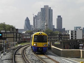
The Metropolitan line, colloquially known as the Met, is a London Underground line between Aldgate in the City of London and Amersham and Chesham in Buckinghamshire, with branches to Watford in Hertfordshire and Uxbridge in Hillingdon. Printed in magenta on the tube map, the line is 41.4 miles (66.7 km) in length and serves 34 stations. Between Aldgate and Finchley Road, the track is mostly in shallow "cut and cover" tunnels, apart from short sections at Barbican and Farringdon stations. The rest of the line is above ground, with a loading gauge of a similar size to those on main lines. Just under 67 million passenger journeys were made on the line in 2011/12.

The Circle line is a spiral-shaped London Underground line, running from Hammersmith in the west to Edgware Road and then looping around central London back to Edgware Road. The railway is below ground in the central section and on the loop east of Paddington. Unlike London's deep-level lines, the Circle line tunnels are just below the surface and are of similar size to those on British main lines. Printed in yellow on the Tube map, the 17-mile (27 km) line serves 36 stations, including most of London's main line termini. Almost all of the route, and all the stations, are shared with one or more of the three other sub-surface lines, namely the District, Hammersmith & City and Metropolitan lines. On the Circle and Hammersmith & City lines combined, over 114 million passenger journeys were recorded in 2011/12.

The District line is a London Underground line running from Upminster in the east and Edgware Road in the west to Earl's Court in west London, where it splits into multiple branches. One branch runs to Wimbledon in south-west London and a short branch, with a limited service, only runs for one stop to Kensington (Olympia). The main route continues west from Earl's Court to Turnham Green after which it divides again into two western branches, to Richmond and Ealing Broadway.
The East London line is part of the London Overground, running north to south through the East, Docklands and South areas of London. It was previously a line of the London Underground.

The Hammersmith & City line is a London Underground line that runs between Hammersmith in west London and Barking in east London. Printed in pink on the Tube map, it serves 29 stations over 15.8 miles (25.5 km). Between Farringdon and Aldgate East it skirts the City of London, the capital's financial heart, hence the line's name. Its tunnels are just below the surface and are a similar size to those on British main lines. Most of the track and all stations are shared with either the District, Circle, or Metropolitan lines. Over 114 million passenger journeys are made each year on the Hammersmith & City and Circle lines.

Whitechapel is a district in East London and the future administrative centre of the London Borough of Tower Hamlets. It is a part of the East End of London, 3.4 miles (5.5 km) east of Charing Cross. Part of the historic county of Middlesex, the area formed a civil and ecclesiastical parish after splitting from the ancient parish of Stepney in the 14th century. It became part of the County of London in 1889 and Greater London in 1965. Because the area is close to the London Docklands and east of the City of London, it has been a popular place for immigrants and the working class.

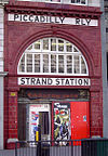
Baker Street is a London Underground station at the junction of Baker Street and the Marylebone Road in the City of Westminster. It is one of the original stations of the Metropolitan Railway (MR), the world's first underground railway, opened on 10 January 1863.

King's Cross Thameslink station is a closed railway station in central London, England. It is located on Pentonville Road, around 250 metres (0.2 mi) east of King's Cross mainline station. At the time of closure, in 2007, it was served by Thameslink trains and managed by First Capital Connect.

Rayners Lane is a London Underground station in the district of Rayners Lane in north west London, amid a 1930s development originally named Harrow Garden Village. The station is on the Uxbridge branch of both the Metropolitan line, between Eastcote and West Harrow stations, and the Piccadilly line, between Eastcote and South Harrow stations. The station is located to the west of the junction of Rayners Lane, Alexandra Avenue and Imperial Drive (A4090). It is in Travelcard Zone 5. Just east of the station, the Piccadilly and Metropolitan lines tracks join for services to Uxbridge and separate for those to Central London.
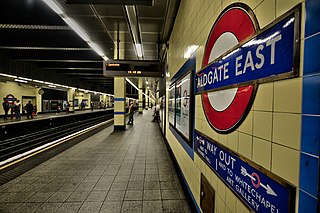
Aldgate East is a London Underground station on Whitechapel High Street in Whitechapel, in London, England. It takes its name from the City of London ward of Aldgate, the station lying to the east of the ward. It is on the Hammersmith & City line between Liverpool Street and Whitechapel, and on the District line between Tower Hill and Whitechapel, in Travelcard Zone 1.

Whitechapel is an interchange station in Whitechapel, East London for London Underground, London Overground and Elizabeth line services. The station is located behind a street market of the same name and opposite the Whitechapel Civic Centre. It lies between Aldgate East and Stepney Green stations on the District and Hammersmith & City lines, between Shoreditch High Street and Shadwell stations on the East London Line and between Liverpool Street and Canary Wharf on the Elizabeth Line. It is in Travelcard Zone 2.

Gloucester Road is a London Underground station in Kensington, west London. The station entrance is located close to the junction of Gloucester Road and Cromwell Road. Close by are the Cromwell Hospital and Baden-Powell House.
The Whitechapel and Bow Railway was an underground railway in east London, United Kingdom, now entirely integrated into the London Underground system. It was a joint venture between the Metropolitan District Railway and the London, Tilbury and Southend Railway.
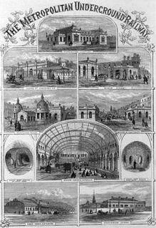
The Metropolitan Railway was a passenger and goods railway that served London from 1863 to 1933, its main line heading north-west from the capital's financial heart in the City to what were to become the Middlesex suburbs. Its first line connected the main-line railway termini at Paddington, Euston, and King's Cross to the City. The first section was built beneath the New Road using cut-and-cover between Paddington and King's Cross and in tunnel and cuttings beside Farringdon Road from King's Cross to near Smithfield, near the City. It opened to the public on 10 January 1863 with gas-lit wooden carriages hauled by steam locomotives, the world's first passenger-carrying designated underground railway.

The Metropolitan District Railway, also known as the District Railway, was a passenger railway that served London from 1868 to 1933. Established in 1864 to complete an "inner circle" of lines connecting railway termini in London, the first part of the line opened using gas-lit wooden carriages hauled by steam locomotives. The Metropolitan Railway operated all services until the District Railway introduced its own trains in 1871. The railway was soon extended westwards through Earl's Court to Fulham, Richmond, Ealing and Hounslow. After completing the inner circle and reaching Whitechapel in 1884, it was extended to Upminster in Essex in 1902.
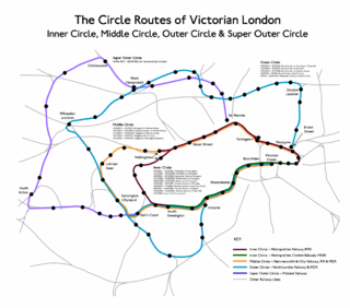
The Middle Circle was a Great Western Railway service in London that operated from 1872 to 1905. The route was from the District Railway station at Mansion House to Earl's Court, then via the West London Railway to Latimer Road on to the Hammersmith & City Railway and then via the Metropolitan Railway to the City of London. Although not a complete circuit, it was one of several 'circle' routes around London that opened at the same time, such as the 'inner circle' that is today's Circle line. Trains would run once every 30 minutes. In 1900 the service was cut back to run from Earl's Court to Aldgate, and ended in 1905.

Whitechapel High Street is a street in the Borough of Tower Hamlets in the East End of London. It is about 0.2 miles long, making it “one of the shortest high streets in London”. It links Aldgate High Street to the south-west with Whitechapel Road to the north-east, and includes junctions with Commercial Street to the north and Commercial Road to the east.
The transport system now known as the London Underground began in 1863 with the Metropolitan Railway, the world's first underground railway. Over the next forty years, the early sub-surface lines reached out from the urban centre of the capital into the surrounding rural margins, leading to the development of new commuter suburbs. At the turn of the nineteenth century, new technology—including electric locomotives and improvements to the tunnelling shield—enabled new companies to construct a series of "tube" lines deeper underground. Initially rivals, the tube railway companies began to co-operate in advertising and through shared branding, eventually consolidating under the single ownership of the Underground Electric Railways Company of London (UERL), with lines stretching across London.
London's Metropolitan Railway (MR) amalgamated with other underground railways, tramway companies and bus operators on 1 July 1933, to form the London Passenger Transport Board (LPTB); the MR became the Board's Metropolitan line.

The history of the District line started in 1864 when the Metropolitan District Railway was created to create an underground 'inner circle' connecting London's railway termini. The first part of the line opened using Metropolitan Railway gas-lit wooden carriages hauled by steam locomotives. The District introduced its own trains in 1871 and was soon extended westwards through Earl's Court to Fulham, Richmond, Ealing and Hounslow. After completing the 'inner circle' and reaching Whitechapel in 1884, it was extended to Upminster in East London in 1902. To finance electrification at the beginning of the 20th century, American financier Charles Yerkes took it over and made it part of his Underground Electric Railways Company of London (UERL) group. Electric propulsion was introduced in 1905, and by the end of the year electric multiple units operated all of the services.


