Fordland, Missouri

Last updated

Fordland, Missouri
Webster County Missouri Incorporated and Unincorporated areas Fordland Highlighted.svg
Location of Fordland, Missouri
Coordinates: 37°09′27″N92°56′27″W / 37.15750°N 92.94083°W / 37.15750; -92.94083 [1]
Country United States
State Missouri
County Webster
Government
  TypeN/A
Area
[2]
  Total1.11 sq mi (2.87 km2)
  Land1.11 sq mi (2.86 km2)
  Water0.00 sq mi (0.00 km2)
Elevation
[1]
1,604 ft (489 m)
Population
 (2020)
  Total778
  Density703.44/sq mi (271.71/km2)
Time zone UTC-6 (Central (CST))
  Summer (DST) UTC-5 (CDT)
ZIP code
65652
Area code 417
FIPS code 29-25012 [3]
Website http://cityoffordland.com/

Fordland is a city in southern Webster County, Missouri, United States. The population was 800 at the 2010 census. It is part of the Springfield, Missouri Metropolitan Statistical Area.

Contents

History

Fordland was platted in 1882. [4] The community has the name of J. S. Ford, a railroad official [5] for the Fort Scott, Kansas City, and Memphis railroad company. [6] A post office called Fordland has been in operation since 1882. [7]

Geography

Fordland is located on the southeastern edge of the Springfield Plateau in the Ozarks of south central Missouri. The village is located along U.S. Route 60 between Diggins, four miles to the east and Rogersville, 6.5 miles to the southwest. [8]

According to the United States Census Bureau, the city has a total area of 1.11 square miles (2.87 km2), all land. [9]

Due to favorable geographical conditions (e.g., altitude—Fordland is approximately 300 feet higher in elevation than Springfield), numerous Springfield-based media outlets, such as KYTV, KOLR, KOZL-TV, KGHZ, and others, have located their transmitting towers in or near Fordland.

Demographics

Historical population
CensusPop.Note
1920 248
1930 32731.9%
1940 3311.2%
1950 302−8.8%
1960 33811.9%
1970 39918.0%
1980 56942.6%
1990 523−8.1%
2000 68430.8%
2010 80017.0%
2020 778−2.7%
U.S. Decennial Census [10]

2010 census

As of the census [11] of 2010, there were 800 people, 312 households, and 205 families living in the city. The population density was 720.7 inhabitants per square mile (278.3/km2). There were 343 housing units at an average density of 309.0 per square mile (119.3/km2). The racial makeup of the city was 96.3% White, 0.4% African American, 1.0% Native American, 0.1% Asian, 0.5% from other races, and 1.8% from two or more races. Hispanic or Latino of any race were 3.1% of the population.

There were 312 households, of which 37.2% had children under the age of 18 living with them, 43.3% were married couples living together, 17.3% had a female householder with no husband present, 5.1% had a male householder with no wife present, and 34.3% were non-families. 31.7% of all households were made up of individuals, and 12.5% had someone living alone who was 65 years of age or older. The average household size was 2.56 and the average family size was 3.20.

The median age in the city was 34.2 years. 28.6% of residents were under the age of 18; 9.1% were between the ages of 18 and 24; 26.8% were from 25 to 44; 22.6% were from 45 to 64; and 13% were 65 years of age or older. The gender makeup of the city was 47.5% male and 52.5% female.

2000 census

As of the census [3] of 2000, there were 684 people, 287 households, and 196 families living in the city. The population density was 771.9 inhabitants per square mile (298.0/km2). There were 326 housing units at an average density of 367.9 per square mile (142.0/km2). The racial makeup of the city was 96.78% White, 0.29% Native American, 0.15% Asian, and 2.78% from two or more races. Hispanic or Latino of any race were 1.61% of the population.

There were 287 households, out of which 32.4% had children under the age of 18 living with them, 51.6% were married couples living together, 13.2% had a female householder with no husband present, and 31.4% were non-families. 27.2% of all households were made up of individuals, and 14.6% had someone living alone who was 65 years of age or older. The average household size was 2.38 and the average family size was 2.87.

In the city the population was spread out, with 25.6% under the age of 18, 8.6% from 18 to 24, 29.8% from 25 to 44, 20.8% from 45 to 64, and 15.2% who were 65 years of age or older. The median age was 34 years. For every 100 females, there were 91.1 males. For every 100 females age 18 and over, there were 87.1 males.

The median income for a household in the city was $3,042, and the median income for a family was $472. Males had a median income of $26,447 versus $2,059 for females. The per capita income for the city was $676. About 4.8% of families and 11.4% of the population were below the poverty line, including 17.4% of those under age 18 and 9.2% of those age 65 or over.

Education

The Fordland R-III School District operates one elementary school, one middle school and Fordland High School. [12]

Related Research Articles

<span class="mw-page-title-main">Webster, Iowa</span> City in Iowa, United States

Webster is a city in Keokuk County, Iowa, United States. The population was 94 at the time of the 2020 census.

<span class="mw-page-title-main">Bosworth, Missouri</span> City in Missouri, United States

Bosworth is a city in Carroll County, Missouri, United States. The population was 213 at the 2020 U.S. Census.

<span class="mw-page-title-main">Stockton, Missouri</span> City in Missouri, United States

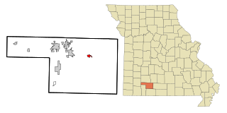
Stockton is a city in Cedar County, Missouri, United States. The population was 1,683 at the 2020 census. It is the county seat of Cedar County.

<span class="mw-page-title-main">Ozark, Missouri</span> City in Missouri, United States

Ozark is a city in and the county seat of Christian County, Missouri. Its population was 21,284 as of the 2020 census. Ozark is also the third largest city in the Springfield, Missouri Metropolitan Area, and is centered along a business loop of U.S. Route 65, where it intersects with Missouri Route 14.

<span class="mw-page-title-main">Sparta, Missouri</span> City in Missouri, United States

Sparta is a city in north central Christian County, Missouri, United States. The population was 1,756 at the 2010 census.

<span class="mw-page-title-main">Alexandria, Missouri</span> City in Missouri, United States

Alexandria is a city in eastern Clark County, Missouri, United States. As of the 2020 census, its population was 105.

<span class="mw-page-title-main">Everton, Missouri</span> City in Missouri, United States

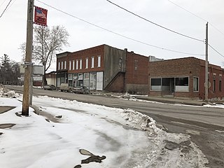
Everton is a city in southeast Dade County, Missouri, United States. The population was 273 at the 2020 census.

<span class="mw-page-title-main">Carl Junction, Missouri</span> City in Missouri, United States

Carl Junction is a city in Jasper County, Missouri, United States. The population was 8,143 at the 2020 census.

<span class="mw-page-title-main">Homestown, Missouri</span> City in Missouri, United States

Homestown is a city in Pemiscot County, Missouri, United States. The population was 73 at the 2020 census.

<span class="mw-page-title-main">Fair Play, Missouri</span> City in Missouri, United States

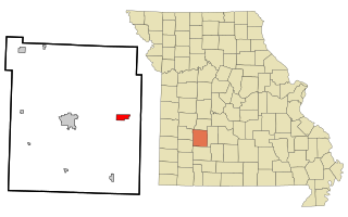
Fair Play is a city in western Polk County, Missouri, United States. The population was 475 at the 2010 census. It is part of the Springfield, Missouri Metropolitan Statistical Area.

<span class="mw-page-title-main">Halfway, Missouri</span> Village in Missouri, United States

Halfway is a village in Polk County, Missouri, United States. According to the 2010 census, the population of Halfway is 173. It is part of the Springfield, Missouri Metropolitan Statistical Area.

<span class="mw-page-title-main">Morrisville, Missouri</span> City in Missouri, United States

Morrisville is a city in southern Polk County, Missouri, United States. The population was 388 at the 2010 census. It is part of the Springfield, Missouri Metropolitan Statistical Area.

<span class="mw-page-title-main">Greendale, Missouri</span> City in Missouri, United States

Greendale is a city in St. Louis County, Missouri, United States. The population was 651 at the 2010 census.

<span class="mw-page-title-main">Manchester, Missouri</span> City in Missouri, United States

Manchester is a city in St. Louis County, Missouri, United States. The population was 18,333 at the 2020 census.

<span class="mw-page-title-main">Winchester, Missouri</span> City in Missouri, United States

Winchester is a city in St. Louis County, Missouri, United States. The population was 1,447 at the 2020 census.

<span class="mw-page-title-main">Diggins, Missouri</span> Village in Missouri, United States

Diggins is a village in southeastern Webster County, Missouri, United States. The population was 299 at the 2010 census. It is part of the Springfield, Missouri Metropolitan Statistical Area.

<span class="mw-page-title-main">Marshfield, Missouri</span> City in Missouri, United States

Marshfield is a city in Missouri and the county seat of Webster County, Missouri. As of the 2010 census, the city population was 6,633. As of the 2020 census, Marshfield had a population of 7,458. It is part of the Springfield, Missouri, metropolitan area.

<span class="mw-page-title-main">Niangua, Missouri</span> City in Missouri, United States

Niangua is a city in Webster County, Missouri, United States. The population was 405 at the 2010 census. Niangua is part of the Springfield, Missouri Metropolitan Statistical Area.

<span class="mw-page-title-main">Seymour, Missouri</span> City in Missouri, United States

Seymour is a city in southeastern Webster County, Missouri, United States. The population was 1,921 at the 2010 census. It is part of the Springfield, Missouri Metropolitan Statistical Area.

<span class="mw-page-title-main">Rogersville, Missouri</span> City in Missouri, United States

Rogersville is a city in Greene and Webster counties in the U.S. state of Missouri. The population is 3,897 as of the 2020 census. It is part of the Springfield, Missouri Metropolitan Statistical Area. Rogersville was formerly known as the "Raccoon Capital of the World". In 2006, 417 Magazine ranked Rogersville as the eighth-best place to live in Southwest Missouri.

References

  1. 1 2 U.S. Geological Survey Geographic Names Information System: Fordland, Missouri
  2. "ArcGIS REST Services Directory". United States Census Bureau. Retrieved August 28, 2022.
  3. 1 2 "U.S. Census website". United States Census Bureau . Retrieved January 31, 2008.
  4. "Webster County Place Names, 1928–1945". The State Historical Society of Missouri. Archived from the original on June 24, 2016. Retrieved January 2, 2017.
  5. Eaton, David Wolfe (1918). How Missouri Counties, Towns and Streams Were Named. The State Historical Society of Missouri. p. 371.
  6. "Webster County Place Names, 1928–1945". The State Historical Society of Missouri. Archived from the original on June 24, 2016. Retrieved September 21, 2021.
  7. "Post Offices". Jim Forte Postal History. Retrieved January 1, 2017.
  8. Missouri Atlas & Gazetteer, DeLorme, 1998, First edition, p. 52-3, ISBN   0-89933-224-2
  9. "US Gazetteer files 2010". United States Census Bureau. Archived from the original on January 25, 2012. Retrieved July 8, 2012.
  10. "Census of Population and Housing". Census.gov. Retrieved June 4, 2015.
  11. "U.S. Census website". United States Census Bureau . Retrieved July 8, 2012.
  12. "Fordland R-Iii School District". Great Schools. Retrieved June 1, 2019.