Graham, Missouri

Last updated

Graham, Missouri
Nodaway County Missouri Incorporated and Unincorporated areas Graham Highlighted.svg
Location of Graham, Missouri
Coordinates: 40°12′05″N95°02′25″W / 40.20139°N 95.04028°W / 40.20139; -95.04028
Country United States
State Missouri
County Nodaway
Area
[1]
  Total0.27 sq mi (0.69 km2)
  Land0.27 sq mi (0.69 km2)
  Water0.00 sq mi (0.00 km2)
Elevation
[2]
958 ft (292 m)
Population
 (2020)
  Total147
  Density552.63/sq mi (213.42/km2)
Time zone UTC-6 (Central (CST))
  Summer (DST) UTC-5 (CDT)
ZIP code
64455
Area code 660
FIPS code 29-28072 [3]
GNIS feature ID2396968 [2]

Graham is a city in Nodaway County, Missouri, United States. The population was 171 at the 2010 census.

Contents

History

Graham was originally called Jacksonville, and under the latter name was platted in 1856. [4] The present name is after Col. Amos Graham, a local clerk. [5] A post office called Graham has been in operation since 1852, however was out of service from 2014 to 2020 due to the building being an extremely hazardous location. [6]

Simpson's College was listed on the National Register of Historic Places in 1978. [7]

Geography

Graham is located at 40°12′5″N95°2′20″W / 40.20139°N 95.03889°W / 40.20139; -95.03889 (40.201473, -95.038877). [8] According to the United States Census Bureau, the city has a total area of 0.26 square miles (0.67 km2), all land. [9]

Demographics

Historical population
CensusPop.Note
1880 452
1890 353−21.9%
1900 3848.8%
1910 365−4.9%
1920 317−13.2%
1930 3479.5%
1940 336−3.2%
1950 311−7.4%
1960 215−30.9%
1970 213−0.9%
1980 25318.8%
1990 204−19.4%
2000 191−6.4%
2010 171−10.5%
2020 147−14.0%
U.S. Decennial Census [10]

2010 census

As of the census [11] of 2010, there were 171 people, 78 households, and 47 families living in the city. The population density was 657.7 inhabitants per square mile (253.9/km2). There were 89 housing units at an average density of 342.3 per square mile (132.2/km2). The racial makeup of the city was 98.8% White and 1.2% African American.

There were 78 households, of which 30.8% had children under the age of 18 living with them, 48.7% were married couples living together, 7.7% had a female householder with no husband present, 3.8% had a male householder with no wife present, and 39.7% were non-families. 38.5% of all households were made up of individuals, and 20.5% had someone living alone who was 65 years of age or older. The average household size was 2.19 and the average family size was 2.91.

The median age in the city was 44.8 years. 22.2% of residents were under the age of 18; 4.7% were between the ages of 18 and 24; 23.4% were from 25 to 44; 29.8% were from 45 to 64; and 19.9% were 65 years of age or older. The gender makeup of the city was 48.5% male and 51.5% female.

2000 census

As of the census [3] of 2000, there were 191 people, 85 households, and 52 families living in the town. The population density was 733.6 inhabitants per square mile (283.2/km2). There were 99 housing units at an average density of 380.2 per square mile (146.8/km2). The racial makeup of the town was 98.43% White, 0.52% African American, and 1.05% from two or more races.

There were 85 households, out of which 24.7% had children under the age of 18 living with them, 52.9% were married couples living together, 5.9% had a female householder with no husband present, and 38.8% were non-families. 32.9% of all households were made up of individuals, and 16.5% had someone living alone who was 65 years of age or older. The average household size was 2.25 and the average family size was 2.85.

In the town the population was spread out, with 23.0% under the age of 18, 5.2% from 18 to 24, 24.1% from 25 to 44, 26.7% from 45 to 64, and 20.9% who were 65 years of age or older. The median age was 44 years. For every 100 females there were 85.4 males. For every 100 females age 18 and over, there were 83.8 males.

The median income for a household in the town was $24,306, and the median income for a family was $40,250. Males had a median income of $28,750 versus $23,750 for females. The per capita income for the town was $13,816. About 17.6% of families and 21.6% of the population were below the poverty line, including 26.1% of those under the age of eighteen and 32.1% of those 65 or over.

Notable people

Education

Nodaway-Holt R-VII School District is the local school district for the area, with an elementary school in Maitland and a junior-senior high and district headquarters in Graham. [12]

Related Research Articles

<span class="mw-page-title-main">Taylor County, Iowa</span> County in Iowa, United States

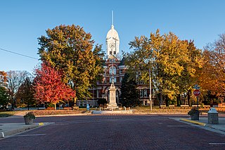
Taylor County is a county located in the U.S. state of Iowa. As of the 2020 census, the population was 5,896, making it the fourth-least populous county in Iowa. The county seat is Bedford. The county was formed in 1847 and named after General and President Zachary Taylor.

<span class="mw-page-title-main">Winston, Florida</span> Place in Florida, United States

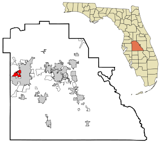
Winston is a former census-designated place (CDP) in Polk County, Florida, United States. The population was 9,024 at the 2000 census. Most of the community's core is now part of neighboring Lakeland. It is part of the Lakeland–Winter Haven Metropolitan Statistical Area.

<span class="mw-page-title-main">Fontanelle, Iowa</span> City in Iowa, United States

Fontanelle is a city in Summerset Township, Adair County, Iowa, United States. The population was 676 at the time of the 2020 census.

<span class="mw-page-title-main">Nodaway, Iowa</span> City in Iowa, United States

Nodaway is a city in Nodaway Township, Adams County, Iowa, United States. The population was 74 at the time of the 2020 census. Nodaway was incorporated in 1900.

<span class="mw-page-title-main">Braddyville, Iowa</span> City in Iowa, United States

Braddyville is a city in Page County, Iowa, United States. The population was 147 at the 2020 census.

<span class="mw-page-title-main">Maitland, Missouri</span> City in Missouri, United States

Maitland is a city in Holt County, Missouri, United States. The population was 276 at the 2020 census. At one point the city billed itself as the "Bluegrass Mecca"—home to the largest bluegrass farm in the world.

<span class="mw-page-title-main">Centerview, Missouri</span> Village in Missouri, United States

Centerview is a village in Johnson County, Missouri, United States. The population was 267 at the 2010 census.

<span class="mw-page-title-main">Arkoe, Missouri</span> Village in Missouri, United States

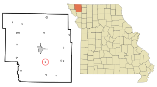
Arkoe is a village in Nodaway County, Missouri, United States. The population was 68 at the 2010 census.

<span class="mw-page-title-main">Barnard, Missouri</span> City in Missouri, United States

Barnard is a city in Nodaway County, Missouri, United States. As of the 2020 census, the city population was 201.

<span class="mw-page-title-main">Burlington Junction, Missouri</span> City in Missouri, United States

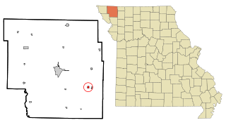
Burlington Junction is a city in Nodaway County, Missouri, United States. The population was 521 at the 2020 census.

<span class="mw-page-title-main">Clearmont, Missouri</span> City in Missouri, United States

Clearmont is a city in northwest Nodaway County, Missouri, United States. The population was 158 at the 2020 census.

<span class="mw-page-title-main">Clyde, Missouri</span> Village in Missouri, United States

Clyde is a village in eastern Nodaway County, Missouri, United States. The population was 82 at the 2010 census.

<span class="mw-page-title-main">Conception Junction, Missouri</span> City in Missouri, United States

Conception Junction is a city in Nodaway County, Missouri, United States, near the Platte River. The population was 177 at the 2020 census.

<span class="mw-page-title-main">Elmo, Missouri</span> City in Missouri, United States

Elmo is a city in Nodaway County, Missouri, United States. The population was 168 at the 2010 census.

<span class="mw-page-title-main">Guilford, Missouri</span> Village in Missouri, United States

Guilford is a village in Nodaway County, Missouri, United States, near the Platte River. The population was 85 at the 2010 census.

<span class="mw-page-title-main">Parnell, Missouri</span> City in Missouri, United States

Parnell is a city in northeast Nodaway County, Missouri, United States, near the Platte River. The population was 191 at the 2010 Census. It was home to the father-son horse trainers Ben and Jimmy Jones, whose horses won eight Kentucky Derbies and two Triple Crowns.

<span class="mw-page-title-main">Pickering, Missouri</span> Village in Missouri, United States

Pickering is a city in Nodaway County, Missouri, United States. The population was 160 at the 2010 census.

<span class="mw-page-title-main">Quitman, Missouri</span> Unincorporated community in Missouri, United States

Quitman is an unincorporated community in west central Nodaway County, Missouri, United States. The population was 45 at the 2010 census.

<span class="mw-page-title-main">Ravenwood, Missouri</span> City in Missouri, United States

Ravenwood is a city in eastern Nodaway County, Missouri, United States, near the Platte River. The population was 439 at the 2020 census.

<span class="mw-page-title-main">Skidmore, Missouri</span> City in Missouri, United States

Skidmore is a city in western Nodaway County, Missouri, United States. The population was 245 at the 2020 Census. The small farming community is known for the unsolved extrajudicial killing of Ken Rex McElroy. Skidmore also has a yearly "Punkin' Show."

References

  1. "ArcGIS REST Services Directory". United States Census Bureau. Retrieved August 28, 2022.
  2. 1 2 U.S. Geological Survey Geographic Names Information System: Graham, Missouri
  3. 1 2 "U.S. Census website". United States Census Bureau . Retrieved January 31, 2008.
  4. "Nodaway County Place Names, 1928–1945". The State Historical Society of Missouri. Archived from the original on June 24, 2016. Retrieved November 24, 2016.
  5. Eaton, David Wolfe (1917). How Missouri Counties, Towns and Streams Were Named. The State Historical Society of Missouri. pp.  336.
  6. "Post Offices". Jim Forte Postal History. Retrieved November 24, 2016.
  7. "National Register Information System". National Register of Historic Places . National Park Service. July 9, 2010.
  8. "US Gazetteer files: 2010, 2000, and 1990". United States Census Bureau. February 12, 2011. Retrieved April 23, 2011.
  9. "US Gazetteer files 2010". United States Census Bureau. Archived from the original on January 25, 2012. Retrieved July 8, 2012.
  10. "Census of Population and Housing". Census.gov. Retrieved June 4, 2015.
  11. "U.S. Census website". United States Census Bureau . Retrieved July 8, 2012.
  12. "Home". Nodaway-Holt R-VII School District . Retrieved January 23, 2021. District Office 318 S. Taylor Street Graham, MO 64455660-939-2135 Elementary School 409 Hickory Street Maitland, MO 64466660-935-2514 High School 318 S. Taylor Street Graham, MO 64455660-939-2135