
In the United States, national forest is a classification of protected and managed federal lands that are largely forest and woodland areas. They are owned collectively by the American people through the federal government and managed by the United States Forest Service, a division of the United States Department of Agriculture. The U.S. Forest Service is also a forestry research organization which provides financial assistance to state and local forestry industry. There are 154 national forests in the United States.
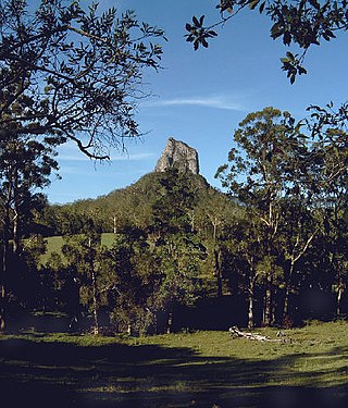
Glass House Mountains National Park is a heritage-listed national park at Glass House Mountains, Sunshine Coast Region, Queensland, Australia. It is also known as Beerburrum Forest Reserve 1. It is 70 km (43 mi) north of Brisbane and consists of a flat plain punctuated by rhyolite and trachyte volcanic plugs, the cores of extinct volcanoes that formed 26 million to 27 million years ago. The mountains would once have had pyroclastic exteriors, but these have eroded away.

The Ozarks, also known as the Ozark Mountains, Ozark Highlands or Ozark Plateau, is a physiographic region in the U.S. states of Missouri, Arkansas, Oklahoma and the extreme southeastern corner of Kansas. The Ozarks cover a significant portion of northern Arkansas and most of the southern half of Missouri, extending from Interstate 40 in central Arkansas to Interstate 70 in central Missouri.

The St. Francois Mountains in southeast Missouri are a mountain range of Precambrian igneous mountains rising over the Ozark Plateau. This range is one of the oldest exposures of igneous rock in North America. The name of the range is spelled out as Saint Francois Mountains in official GNIS sources, but it is sometimes misspelled in use as St. Francis Mountains to match the anglicized pronunciation of both the range and St. Francois County.

Meramec State Park is a public recreation area located near Sullivan, Missouri, about 60 miles from St. Louis, along the Meramec River. The park has diverse ecosystems such as hardwood forests and glades. There are over 40 caves located throughout the park, the bedrock is dolomite. The most famous is Fisher Cave, located near the campgrounds. The park borders the Meramec Conservation Area.

Mark Twain National Forest (MTNF) is a U.S. National Forest located in the southern half of Missouri, composed of nine disconnected parcels. MTNF was established on September 11, 1939. It is named for author Mark Twain, a Missouri native. The MTNF covers 3,068,800 acres (12,419 km2) of which 1,506,100 acres (6,095 km2) is public owned, 78,000 acres (320 km2) of which are Wilderness, and National Scenic River area. MTNF spans 29 counties and represents 11% of all forested land in Missouri. MTNF's nine tracts are divided into six distinct ranger districts: Ava-Cassville-Willow Springs, Eleven Point, Houston-Rolla, Cedar Creek, Poplar Bluff, Potosi-Fredericktown, and the Salem. Its headquarters are in Rolla, Missouri.
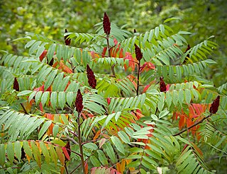
Rhus typhina, the staghorn sumac, is a species of flowering plant in the family Anacardiaceae, native to eastern North America. It is primarily found in southeastern Canada, the northeastern and midwestern United States, and the Appalachian Mountains, but it is widely cultivated as an ornamental throughout the temperate world. It is an invasive species in some parts of the world.
A shut-in is a type of rock formation found in streams in the Ozarks, comprising pools, rivulets, rapids and plunge pools. The term has an origin in Appalachia.
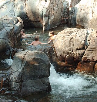
Johnson's Shut-Ins State Park is a public recreation area covering 8,781 acres (3,554 ha) on the East Fork Black River in Reynolds County, Missouri. The state park is jointly administered with adjoining Taum Sauk Mountain State Park, and together the two parks cover more than sixteen thousand acres in the St. Francois Mountains region of the Missouri Ozarks.

The United States Congress designated the Bell Mountain Wilderness in 1980. The wilderness area now has a total of 9,027 acres (36.53 km2). Bell Mountain is located within the Potosi-Fredericktown Ranger District of the Mark Twain National Forest, south of Potosi, Missouri in the United States. The wilderness lies in the Saint Francois Mountains and it was named after its highest point, Bell Mountain. The namesake Bell Mountain has the name of Henry Bell, a pioneer settler. The Bell Mountain Wilderness is one of eight wilderness areas protected and preserved in Missouri. The area is popular for hiking as there are 12 miles (19 km) of trail, including a section of the Ozark Trail.
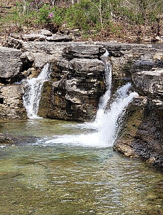
The Hercules Glades Wilderness is a 12,314-acre (50 km2) wilderness area in Taney County in the Ozarks of southwest Missouri. The United States Congress designated it a wilderness in 1976, making it the oldest wilderness area in Missouri. It is one of eight wilderness areas in the Mark Twain National Forest and is within the Ava-Cassville-Willow Springs ranger district, about 10 miles (16 km) northeast of Branson, Missouri. Hercules Glades Wilderness derives its name from the open limestone glades (balds) that dot its landscape. The high points of Coy Bald and Pilot Knob stand 600 feet above Long Creek and offer splendid views of the drainage. Near the middle of the wilderness area is the main set of waterfalls, though Long Creek has several other smaller waterfalls and cascades along its path.
Knob Lick is an unincorporated community in southern Saint Francois County, Missouri, United States. It is located on Missouri Route DD, just east of U.S. Route 67, approximately eight miles south of Farmington.
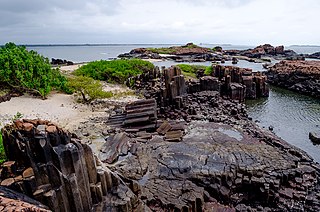
St. Mary's Islands, also known as Coconut Island and Thonsepar, are a set of four small islands in the Arabian Sea off the coast of Malpe in Udipi, Karnataka, India. They are known for their distinctive geological formation of columnar rhyolitic lava (pictured).

Grand Gulf State Park is a state-operated, privately owned and publicly accessible, geologic preserve near Thayer, Missouri, United States, encompassing a forked canyon that is the remnant of an ancient collapsed dolomite cave system. The land that is now the park was acquired by conservationist Leo Drey (1917–2015) before becoming part of the Missouri state parks system. The 322-acre (130 ha) state park has been operated by the Missouri Department of Natural Resources under a lease agreement with the L-A-D Foundation since 1984. Grand Gulf was declared a National Natural Landmark in 1971 as an excellent example of karst topography and underground stream piracy. A 60-acre (24 ha) portion of the park was designated by the state as the Grand Gulf Natural Area in 1986.

Columnar jointing is a geological structure where sets of intersecting closely spaced fractures, referred to as joints, result in the formation of a regular array of polygonal prisms, or columns. Columnar jointing occurs in many types of igneous rocks and forms as the rock cools and contracts. Columnar jointing can occur in cooling lava flows and ashflow tuffs (ignimbrites), as well as in some shallow intrusions. Columnar jointing also occurs rarely in sedimentary rocks, due to a combination of dissolution and reprecipitation of interstitial minerals by hot, hydrothermal fluids and the expansion and contraction of the rock unit, both resulting from the presence of a nearby magmatic intrusion.

The Ozark Highlands is a Level III ecoregion designated by the Environmental Protection Agency (EPA) in four U.S. states. Most of the region is within Missouri, with a part in Arkansas and small sections in Oklahoma and Kansas. It is the largest subdivision of the region known as the Ozark Mountains, less rugged in comparison to the Boston Mountains in Arkansas, the highest part of the Ozarks.

Pilot Knob is located in the Arcadia Valley of Iron County, Missouri, between the towns of Ironton and Pilot Knob. Pilot Knob, so named because of its distinctive shape and prominent position, reaches an elevation of 1,470 feet (450 m) rising 581 feet (177 m) above the Arcadia Valley floor and has a large deposit of iron ore in its upper regions. Pilot Knob is a peak in the St. Francois Mountains.

Devil's Den State Park is a 2,500-acre (1,000 ha) Arkansas state park in Washington County, near West Fork, Arkansas in the United States. The park was built by the Civilian Conservation Corps, beginning in 1933. Devil's Den State Park is in the Lee Creek Valley in the Boston Mountains, which are the southwestern part of The Ozarks. The park, with an 8 acres (3.2 ha) CCC-built lake, is open for year-round recreation, with trails for hiking, mountain biking and horseback riding. Devil's Den State Park also has several picnic areas, a swimming pool and cabins, with camping sites ranging from modern to primitive. Fossils of coral and crinoids can be found along the banks and within Lee Creek at Devil's Den State Park.

The Mount Rogers Cluster is a region recognized by The Wilderness Society for its unique high elevation mountains, vistas, trout streams and wildlife habitat. The heart of the region is Mount Rogers, the highest mountain in Virginia. The area extends over the Mount Rogers National Recreation Area and into part of the Cherokee National Forest.


