International District (Greater Houston)

Last updated

InternationalDistrictHoustonLogo.png
District offices InternationaLDistOFF.jpg
District offices
District street scene Internationaldistrictsigns.JPG
District street scene

The International Management District (IMD) or simply the International District (ID) is a management district in Harris County and Fort Bend County, Texas. Most of the district is within the city of Houston, while a portion lies within an unincorporated area. [1]

Contents

History

Texas State Representative Hubert Vo suggested the creation of a management district. [2] The 80th session of the Texas Legislature created the district in 2007. [3] In 2009 the district stated that at least half of its $1 million budget would be used to enhance security. [4]

Cityscape

The district has about 12 square miles (31 km2) of land. It is roughly bounded by Bellaire Boulevard to the north, Texas State Highway 6 to the west, and Beltway 8 to the east. The district runs along Bissonnet from Highway 6 to Kirkwood. The district then runs along West Bellfort to U.S. Highway 59. [2] The area occupied by the district is commonly known as Alief. [5] As of 2011 seven hotels are located in the district. [6]

Government and infrastructure

The International Management District levies taxes on businesses in its boundaries to increase security, to promote international business and trade, and to pay for beautification projects. [3]

County, state, and federal representation

The Harris County Sheriff's Office serves the unincorporated Harris County side. It operates the Mission Bend Storefront in the International District. [1] [7] The El Franco Lee Health Center in the district, operated by the Harris County Hospital District, opened on May 19, 2009. [8] Prior to the opening, the closest facility was the People's Health Center. The district said in a 2006 Houston Chronicle article that it planned to build a health care facility in Alief. [9] The center has 66,000 square feet (6,100 m2) of space. [10]

The United States Postal Service operates the Alief Post Office and the Beechnut Post Office. [11] [12]

Economy

The International Trade Center-Houston was established around the time of the formation of the International District. [13]

The offices of Sentai Filmworks are in the International District. [14] [15]

Education

Primary and secondary schools

The Harris County residents are within the Alief independent school District. [1] The Fort Bend County residents are within the Fort Bend independent school District. [1] Christina Autry of the IMD wrote that "The International Management District (IMD) largely overlaps with Alief ISD". [16]

Alief ISD schools in the district boundaries include: [17]

Each area is assigned to a particular elementary school, with several areas assigned to elementary schools outside of the district. Some schools do not have bilingual programs, so bilingual students for those schools are redirected to other schools. [18] In addition to the intermediate schools above, Alief Intermediate, Budewig, Mata, and Miller serve sections of the district, with bilingual students at Alief Int. being redirected to Owens. [19] In addition to the middle schools above, Alief Middle, Albright, and Holub middle schools serve portions of the district. [20] High school students in Alief ISD are randomly assigned to either Elsik, Hastings, or Taylor, with the same institution for all grade levels, while Kerr and Alief Early College serve as magnet schools. [21]

The Fort Bend County portion is served by Arizona Fleming Elementary School, [22] Hodges Bend Middle School, [23] and George Bush High School. [24]

Community colleges

The Houston Community College System has served the Alief area since 1982. [25] The HCC Alief Campus, a part of the Southwest College, [26] is in the Westchase area of Houston. [25] [27] The HCC Alief Continuing Education Center is located in an unincorporated area in Harris County adjacent to the International District. [25] In 1982 HCCS expanded classes to Alief Elsik High School. In 2001, HCCS opened the Alief Center on Bissonnet. In 2007, the new Alief Campus in Westchase opened. In 2008, the former Alief Center became the Continuing Education Center. [25]

Public libraries

Houston Public Library operates the David M. Henington-Alief Regional Library in the district. [28]

Recreation

The Lunar New Year is celebrated in the district. [29]

Related Research Articles

<span class="mw-page-title-main">Harris County, Texas</span> County in Texas, U.S.

Harris County is a county located in the U.S. state of Texas; as of the 2020 census, the population was 4,731,145, making it the most populous county in Texas and the third-most populous county in the United States. Its county seat is Houston, the most populous city in Texas and fourth-most populous city in the United States. The county was founded in 1836 and organized in 1837. It is named for John Richardson Harris, who founded the town of Harrisburg on Buffalo Bayou in 1826. According to the July 2022 census estimate, Harris County's population has shifted to 4,780,913 comprising over 16% of Texas's population. Harris County is included in the nine-county Houston–The Woodlands–Sugar Land metropolitan statistical area, which is the fifth-most populous metropolitan area in the United States.

Arcola is a city in Fort Bend County, Texas, United States, within the Houston–Sugar Land–Baytown metropolitan area. The population was 2,034 as of the 2020 census, an increase over the figure of 1,642 tabulated by the 2010 census, which represented, in turn, an increase over the 2000 figure of 1,048.

<span class="mw-page-title-main">Meadows Place, Texas</span> City in Texas, United States

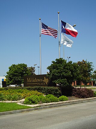
Meadows Place is a city located in Fort Bend County in the U.S. state of Texas within the Houston–Sugar Land–Baytown metropolitan area. As of the 2020 U.S. Census, the city population was 4,767.

<span class="mw-page-title-main">Katy, Texas</span> City in Texas, United States

Katy is a city in the U.S. state of Texas. It is in the Greater Katy area, itself forming the western part of the Greater Houston metropolitan area. Homes and businesses may have Katy postal addresses without being in the City of Katy. The city of Katy is approximately centered at the tripoint of Harris, Fort Bend, and Waller counties. Katy had a population of 21,894 at the 2020 U.S. census, up from 14,102 in 2010.

<span class="mw-page-title-main">Mission Bend, Texas</span> Census-designated place in Texas, United States

Mission Bend is a census-designated place (CDP) around Texas State Highway 6 within the extraterritorial jurisdiction of Houston in Fort Bend and Harris counties in the U.S. state of Texas; Mission Bend is 4 miles (6 km) northwest of the city hall of Sugar Land and 20 miles (32 km) southwest of Downtown Houston. The population was 36,914 at the 2020 census.

<span class="mw-page-title-main">Chinatown, Houston</span> Neighborhood of Houston in Harris County, Texas, United States

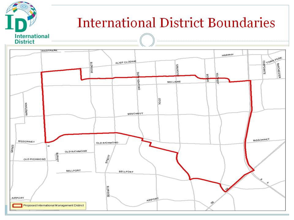
Chinatown is a community in Southwest Houston, Texas, United States.

<span class="mw-page-title-main">Alief Hastings High School</span> High school in Houston, Texas

Alief Hastings High School is a public high school in the Alief area of Houston, Texas, United States. Originally Alief Junior-Senior High School, which became Alief Middle School, housed all of the secondary students in the district. The school's present location opened, while still under construction, for the fall semester of 1972. All high school students moved to that building, with the first graduating class in May 1973.

<span class="mw-page-title-main">Alief Independent School District</span> School district in Houston, Texas

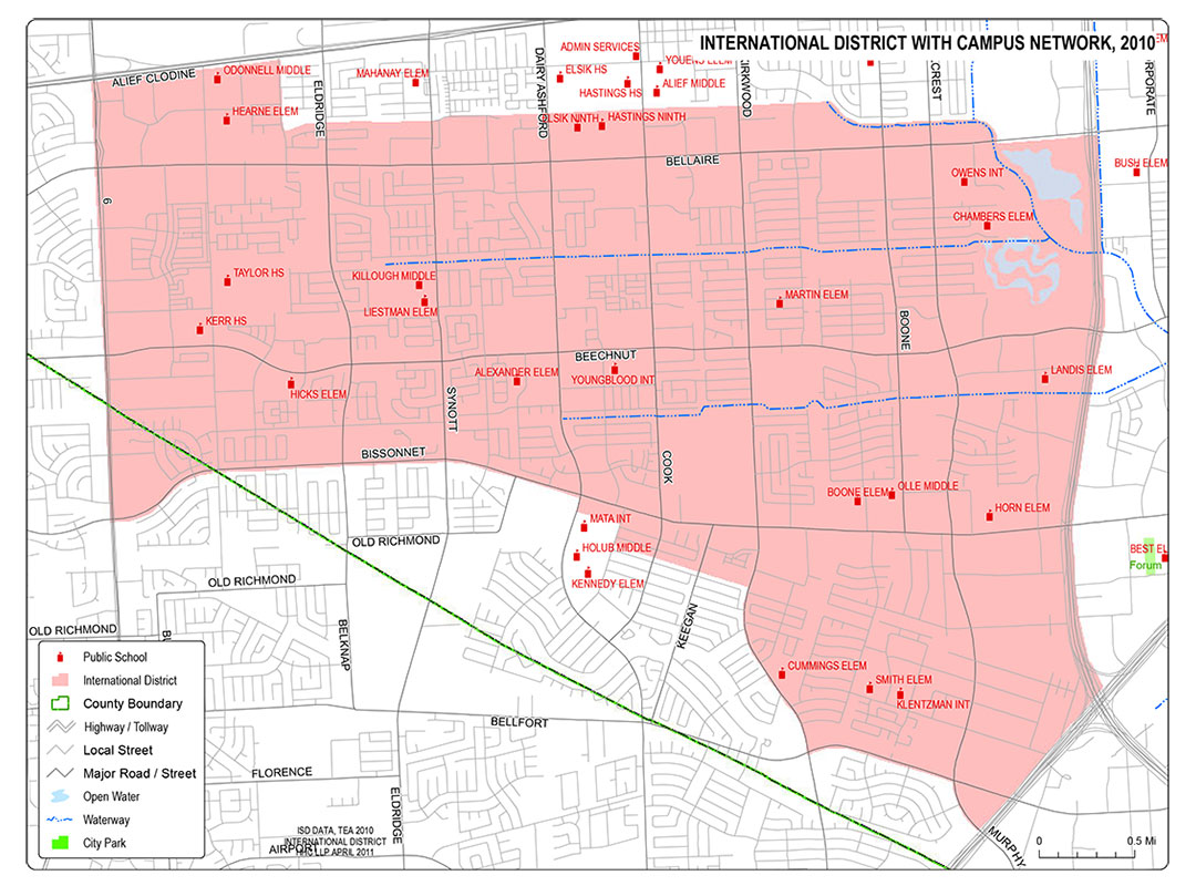
Alief Independent School District is a school district that is based in southwest Houston, Texas, United States.

Alief is a working-class suburb in Southwest Harris County, Texas, United States. Most of Alief is within the city limits of Houston, while a portion of the community is in unincorporated Harris County.

<span class="mw-page-title-main">Westchase, Houston</span> Place in Texas, United States

Westchase is a business district and neighborhood in western Houston, Texas, bounded by Westheimer Road on the north, Gessner Road on the east, Houston Center Boulevard on the west, and Westpark Tollway on the south. The area is bisected by Beltway 8. Westchase is adjacent to Greater Sharpstown, the International District, and the Royal Oaks Country Club subdivision. The area is immediately northeast of Alief.

<span class="mw-page-title-main">Alief Elsik High School</span> Public school in Texas, United States

Alief Elsik High School is a high school in the Alief region of Houston, Texas, United States.

<span class="mw-page-title-main">Alief Taylor High School</span> Public school in Texas, United States

Alief Taylor High School is a public high school in the Alief Independent School District. It is located in an unincorporated area in the Alief community of Harris County, near Houston, Texas, United States. Opened in 2001, Alief Taylor is the newest high school in the district. It is named after Edward "Doc" Taylor, who taught AP American History at Alief Hastings High School.

<span class="mw-page-title-main">Royal Oaks Country Club</span> Country club and subdivision in Texas, United States

Royal Oaks Country Club is a country club and subdivision in Houston, Texas, United States, in the Alief community. The country club is located at 2910 Royal Oaks Club Drive, 8 miles (13 km) west of The Galleria. Sunrise Colony Company developed Royal Oaks out of the former Andrau Airpark property.

<span class="mw-page-title-main">Houston Energy Corridor</span> Business district of Greater Houston in Texas, United States

The Energy Corridor is a business district in Houston, Texas, located on the west side of the metropolitan area between Beltway 8 and the Grand Parkway. The district straddles a 7-mile (11 km) stretch of Interstate 10 from Kirkwood Road westward to Barker Cypress Road and extends south along Eldridge Parkway to Briar Forest Drive. Parts of the district overlap with the Memorial area of Houston. The district is located north of Westchase, another major business district of Houston, and east of Greater Katy.

Greater Katy Area is the term often used to refer to a suburban region on the west side of the Greater Houston metropolitan area roughly corresponding to the boundaries of the Katy Independent School District. Many people and businesses in this area have a Katy address, but are not part of the city of Katy. This area includes the suburbs that surround the Katy city limits west to Pederson road, roughly east to State Highway 6, north to FM 529, and south to FM 1093/ Westpark Tollway Parkway. While these boundaries are not exact, it gives a rough outline of what most people consider Greater Katy, and what the USPS designates as "Katy, Texas" by assigning that city to addresses within zip codes that fall in this region. Most of Greater Katy is to the east of the city of Katy toward Houston and includes surrounding suburban areas and unincorporated areas that are not in the Houston city limits. The region includes parts of Harris County, Fort Bend County, and Waller County much as the City of Katy does. Greater Katy is one of the fastest-growing portions of the Houston metropolitan area and the state of Texas as a whole.

<span class="mw-page-title-main">Houston Community College</span> Community college system in Texas, U.S.

Houston Community College (HCC), also known as Houston Community College System (HCCS), is a community college system that operates community colleges in Houston, Missouri City, Greater Katy, and Stafford in Texas. It is notable for actively recruiting internationally and for the large number of international students enrolled, over 5,700 in 2015. Its open enrollment policies, which do not require proficiency in English, are backed by a full-time 18-month English proficiency program and remedial courses.

<span class="mw-page-title-main">Brays Oaks, Houston</span> Area in Southwest Houston, Texas, United States

Brays Oaks, formerly known as Fondren Southwest, is an area in Southwest Houston, Texas, United States. The Brays Oaks Management District, also known as the Harris County Improvement District #5, governs the Brays Oaks area as well as other surrounding areas, such as Westbury. The City of Houston also defines the Brays Oaks Super Neighborhood, with separate boundaries.

<span class="mw-page-title-main">Southwest Management District</span> District in Houston, Texas

Southwest Management District, formerly Greater Sharpstown Management District, is a district in Houston, Texas, United States. The district is split into 6 neighborhoods: Sharpstown, Chinatown, Mahatma Gandhi District/Little India, Westwood, Harwin, and University.

<span class="mw-page-title-main">Forum Park, Houston</span>

Forum Park is a community in Houston, Texas. It is bounded by Texas State Highway Beltway 8, U.S. Route 59, and Bissonnet Road. A portion of the community resides in the Greater Sharpstown district.

References

  1. 1 2 3 4 "International District Boundaries Archived 2011-07-26 at the Wayback Machine ." International District. Retrieved May 2, 2010.
  2. 1 2 "Welcome to the International Management District." International Management District. Retrieved June 2, 2010.
  3. 1 2 Kumar, Seshadri and Jennifer Friedberg. "Alief set to establish International Management District / Second bill can let AISD board increase length of trustees' terms." Houston Chronicle . Thursday June 7, 2007. ThisWeek 7. Retrieved June 2, 2010.
  4. Martin, Betty L. "INTERNATIONAL MANAGEMENT DISTRICT." Houston Chronicle . March 17, 2009. Retrieved June 2, 2010.
  5. "About the District Archived 2011-07-26 at the Wayback Machine ." International Management District. Retrieved June 2, 2010.
  6. "Hotels Archived 2011-07-26 at the Wayback Machine ." International District. Retrieved June 2, 2010.
  7. "Contact Information Archived 2010-03-03 at the Wayback Machine ." Harris County Sheriff's Office. Retrieved May 28, 2010.
  8. "El Franco Lee Health Center Archived 2009-05-02 at the Wayback Machine ." Harris County Hospital District . Retrieved April 26, 2009.
  9. Kumar, Seshadri. "County plans Alief health center / Twelve-acre facility would be largest in HCHD." Houston Chronicle . Thursday October 26, 2006. ThisWeek 5. Retrieved May 25, 2009.
  10. "HCHD Set to Open New El Franco Lee Health Center in Alief Archived 2011-07-18 at the Wayback Machine ." Harris County Hospital District. Retrieved March 18, 2010.
  11. "Post Office Location – ALIEF Archived 2010-05-20 at the Wayback Machine ." United States Postal Service. Retrieved June 3, 2010.
  12. "Post Office Location – BEECHNUT Archived 2010-05-17 at the Wayback Machine ." United States Postal Service. Retrieved June 3, 2010.
  13. Wollam, Allison. "New district imports global trade center." Houston Business Journal . Friday October 26, 2007. Retrieved June 2, 2010.
  14. "International District Boundaries". International District (Houston). July 1, 2015. Retrieved November 13, 2019.
  15. "Terms of Use". Sentai Filmworks. Retrieved November 13, 2019. Copyright Agent c/o SENTAI FILMWORKS 10114 W Sam Houston Pkwy S Houston, Texas 77099-5109 and Privacy Policy states: "Attn: SENTAI FILMWORKS Privacy Administration, 10114 W. Sam Houston Parkway South, Suite 100, Houston, Texas 77099-5109"
  16. Autry, Christina. "Q&A With Superintendent of Alief ISD and IMD Board Member HD Chambers". International District, Houston. Retrieved August 14, 2019. The International Management District (IMD) largely overlaps with Alief ISD[...]
  17. "International District with Campus Network, 2010". International District. Retrieved August 14, 2019.
  18. "Elementary School Attendance Boundary Map". Alief Independent School District . Retrieved August 14, 2019.Regular boundary PDF and Bilingual boundary PDF
  19. "Intermediate School Attendance Boundary Map". Alief Independent School District . Retrieved August 14, 2019.Regular boundary PDF and Bilingual Boundary PDF.
  20. "Middle School Attendance Boundary Map". Alief Independent School District . Retrieved August 14, 2019.PDF.
  21. "Alief ISD High School Information". Alief Independent School District . Retrieved August 14, 2019.
  22. "2009–2010 Elementary Schools [ permanent dead link ]." Fort Bend Independent School District. Retrieved June 2, 2010.
  23. "2009–2010 Middle Schools [ permanent dead link ]." Fort Bend Independent School District. Retrieved June 2, 2010.
  24. "2009–2010 High Schools [ permanent dead link ]." Fort Bend Independent School District. Retrieved June 2, 2010.
  25. 1 2 3 4 "HCC provides opportunity and education for the Alief community [ permanent dead link ]." Houston Community College System . Retrieved April 8, 2009.
  26. "HCC Southwest College Archived 2013-10-31 at the Wayback Machine ." Houston Community College . Retrieved April 8, 2009.
  27. "SECT2-key.gif Archived 2009-02-27 at the Wayback Machine ." Westchase . Retrieved April 8, 2009.
  28. "Henington-Alief Regional Library Archived 2010-04-20 at the Wayback Machine ." Houston Public Library. Retrieved June 3, 2010.
  29. "2010 Chinese Lunar New Year Festival Archived 2011-07-26 at the Wayback Machine ." International District. Retrieved June 3, 2010.