
Southside Place is a city in west central Harris County, Texas, United States. The population was 1,835 at the 2020 census.

West University Place, often called West University or West U for short, is a city located in the U.S. state of Texas within the Houston–Sugar Land metropolitan area and southwestern Harris County. At the 2020 U.S. census, the population of the city was 14,955. It is nicknamed "The Neighborhood City" and is mainly a bedroom community for upper-class families.
River Oaks is a residential community located in the center of Houston, Texas, United States. Located within the 610 Loop and between Downtown and Uptown, the community spans 1,100 acres (450 ha). Established in the 1920s by brothers Will Hogg and Michael Hogg, the community became a well-publicized national model for community planning. Real estate values in the community range from $1 million to over $20 million. River Oaks was also named the most expensive neighborhood in Houston in 2013. The community is home to River Oaks Country Club, which includes a golf course designed by architect Donald Ross and redesigned in 2015 by Tom Fazio.

South Park is a broad post-World War II development in the south-central area of Houston, Texas, a few miles south of MacGregor Park and directly south of the 610 Loop. According to the 2000 Census, the community has a population of 22,282. 81% of the South Park population is African American, compared to 25% for the city as a whole. Houston's Martin Luther King Boulevard runs through the area. Reflecting its postwar origins, many streets in South Park are named after World War II battle sites and persons. In the 1980s and 1990s crime became a key issue for South Park. Katharine Shilcutt of the Houston Press said "South Park is an overgrown garden these days, its soil only able to be tilled by the most determined or the most desperate. It shows no sign that it will grow again any time in the near future."
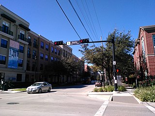
Midtown is a central neighborhood of Houston, located west-southwest of Downtown. Separated from Downtown by an elevated section of Interstate 45, Midtown is characterized by a continuation of Downtown's square grid street plan, anchored by Main Street and the METRORail Red Line. Midtown is bordered by Neartown (Montrose) to the west, the Museum District to the south, and Interstate 69 to the east. Midtown's 325 blocks cover 1.24 square miles (3.2 km2) and contained an estimated population of nearly 8,600 in 2015.

Upper Kirby is a commercial district in Houston, Texas, United States. It is named after Kirby Drive, so indirectly takes its name from John Henry Kirby.

Southampton Place, also known as Southampton, is a neighborhood located in Houston, Texas. The Southampton Civic Club Inc. is the homeowners' association.
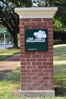
Old Braeswood is a neighborhood of single family homes in Houston, Texas, United States. It is generally bounded by South Main, North Braeswood, Kirby Drive, and Holcombe. The Texas Medical Center, Rice University, Rice Village, and the NRG Center complex are all within a one-mile radius. Nearby neighborhoods include Southgate, West University Place and Braeswood Place.
Southgate is a neighborhood in Houston, Texas, United States.

Boulevard Oaks is a neighborhood in Houston, Texas, United States, containing 21 subdivisions north of Rice University and south of U.S. Highway 59. Developed primarily during the 1920s and 1930s, Boulevard Oaks contains two National Register historic districts, Broadacres and Boulevard Oaks. The Boulevard Oaks Civic Association (BOCA) is the common civic association for all 21 subdivisions.

Highland Village is a neighborhood in Houston, Texas, United States.

Montrose is a neighborhood located in west-central Houston, Texas, United States. Montrose is a 7.5-square-mile (19 km2) area roughly bounded by Interstate 69/U.S. Highway 59 to the south, Allen Parkway to the north, South Shepherd Drive to the west, and Taft to Fairview to Bagby to Highway 59 to Main to the east. The area is also referred to as Neartown or Neartown / Montrose.
The following is a list of neighborhoods and commercial districts in Sioux City, Iowa.

Rice Epicurean Markets was an American niche grocery store chain based in Southwest Houston, Houston, Texas. There is now just one supermarket left of the chain. Prior to 2012 the company operated five Rice Epicurean Markets, which ranged in size from 25,000 to 42,000 square feet (3,900 m2). At its height, it operated 35 stores. The last Rice Epicurean Market is wholly owned by founding family members.
Morningside Place is a group of subdivisions located in Houston, Texas, United States.
Riverside Terrace is a neighborhood in Houston, Texas, United States. It is along Texas State Highway 288 and north of the Texas Medical Center and located near Texas Southern University and University of Houston. There about 20 sections of Riverside Terrace that span across North and South MacGregor. The community, formerly an affluent Jewish neighborhood, became an affluent community for African Americans in the 1950s and '60s. It is still predominantly African American neighborhood with different income levels. It has been undergoing a gradual change in demographics and aesthetics due to gentrification efforts since the early 2000s.
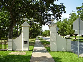
The campus of Rice University is located on a heavily wooded 290-acre (120-hectare) plot of land on South Main Street in the Museum District of Houston, Texas. It is located east of Rice Village, a retail district, south of Boulevard Oaks and Southampton, west of the Texas Medical Center, and north of Southgate.

The Village News and Southwest News is a local newspaper in Greater Houston, headquartered in Bellaire, Texas.

The Village Arcade Shopping Center is a shopping center in Rice Village, Houston, Texas owned by Rice University.

