
Papua, formerly Irian Jaya, is the largest and easternmost province of Indonesia, comprising most of Western New Guinea. The province is located on the island of New Guinea. It is bordered by the state of Papua New Guinea to the east, the province of West Papua to the west, the Pacific Ocean to the north, and the Arafura Sea to the south. The province also shares maritime boundaries with Palau to the north. The province is divided into twenty-eight regencies and one city. Its capital and largest city is Jayapura. The province has a large potential in natural resources, such as gold, nickel, petroleum, etc. Puncak Jaya is the province's highest mountain and the highest point in Indonesia. Papua, along with West Papua, has a higher degree of autonomy level compared to other Indonesian provinces.

Papua New Guinea, officially the Independent State of Papua New Guinea, is a country in Oceania that comprises the eastern half of the island of New Guinea and its offshore islands in Melanesia. Its capital, located along its southeastern coast, is Port Moresby. It is the world's third largest island country with an area of 462,840 km2 (178,700 sq mi).

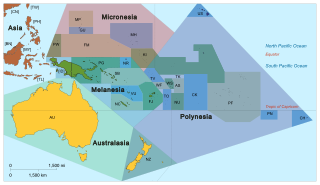
Melanesia is a subregion of Oceania in the southwestern Pacific Ocean. It extends from the island of New Guinea in the west to Tonga in the east, and includes the Arafura Sea.

Bougainville, officially the Autonomous Region of Bougainville, is an autonomous region in Papua New Guinea. The largest island is Bougainville Island, while the region also includes Buka Island and a number of outlying islands and atolls. The interim capital is Buka, though it is expected that major government services and buildings will be moved to Arawa, following reconstruction.
Pacific Islanders, Pacificer, Pasifika, or Pasefika, are the peoples of the Pacific Islands—particularly those who are indigenous to them.

Bougainville Island is the main island of the Autonomous Region of Bougainville, which is part of Papua New Guinea. It was previously the main landmass in the German Empire-associated North Solomons. Its land area is 9,300 km2 (3,600 sq mi). The population of the whole province, including nearby islets such as the Carterets, is approximately 300,000. The highest point is Mount Balbi, on the main island, at 2,715 m (8,907 ft). The much-smaller Buka Island, c. 500 km2 (190 sq mi), lies to the north, across the 400–500 m (1,300–1,600 ft) wide Buka Strait. Even though the strait is narrow, there is no bridge across it. But there is a regular ferry service between the key settlements on either side. The main airport in the north is in the town of Buka.

The Papuan languages are the non-Austronesian and non-Australian languages spoken on the western Pacific island of New Guinea, and neighbouring islands, by around 4 million people. It is a strictly geographical grouping, and does not imply a genetic relationship. The concept of Papuan peoples as distinct from Austronesian-speaking Melanesians was first suggested and named by Sidney Herbert Ray in 1892.
The East Papuan languages is a defunct proposal for a family of Papuan languages spoken on the islands to the east of New Guinea, including New Britain, New Ireland, Bougainville, Solomon Islands, and the Santa Cruz Islands. There is no evidence that these languages are related to each other, and the Santa Cruz languages are no longer recognized as Papuan.

West Papua, formerly Irian Jaya Barat or Irian Barat, is a province of Indonesia. It covers the two western peninsulas of the island of New Guinea, Bird's Head Peninsula and Bomberai Peninsula, along with nearby islands. The province is bordered to the north by the Pacific Ocean, to the west by the Halmahera Sea and the Ceram Sea, to the south by the Banda Sea, and to the east by the province of Papua and the Cenderawasih Bay. Manokwari is the province's capital, while Sorong is its largest city. West Papua is the second-least populous province in Indonesia, with a population of 1,134,068 at the 2020 Census.

The indigenous peoples of New Guinea, commonly called Papuans, are Melanesians. There is genetic evidence for two major historical lineages in New Guinea and neighboring islands:
- a first wave from the Malay Archipelago perhaps 50,000 years ago when New Guinea and Australia were a single landmass called Sahul,
- and, much later, a wave of Austronesian people from the north who introduced Austronesian languages and pigs about 3,500 years ago, and who left a small but significant genetic trace in many coastal Papuan peoples.

Western New Guinea, also known as Papua, is the western portion of the island of New Guinea controlled by Indonesia since 1962. Since the island is alternatively named as Papua, the region is also called West Papua. Lying to the west of Papua New Guinea, it is the only Indonesian territory situated in Oceania. Considered to be a part of the Australian continent, the territory is mostly in the Southern Hemisphere and includes the Schouten and Raja Ampat archipelagoes. The region is predominantly covered with ancient rainforest where numerous traditional tribes live such as the Dani of the Baliem Valley although a large proportion of the population live in or near coastal areas with the largest city being Jayapura.

The approximately 450 Oceanic languages are a branch of the Austronesian languages. The area occupied by speakers of these languages includes Polynesia, as well as much of Melanesia and Micronesia. Though covering a vast area, Oceanic languages are spoken by only two million people. The largest individual Oceanic languages are Eastern Fijian with over 600,000 speakers, and Samoan with an estimated 400,000 speakers. The Gilbertese (Kiribati), Tongan, Tahitian, Māori, Western Fijian and Tolai languages each have over 100,000 speakers. The common ancestor which is reconstructed for this group of languages is called Proto-Oceanic.

The North Bougainville or West Bougainville languages are a small language family spoken on the island of Bougainville in Papua New Guinea. They were classified as East Papuan languages by Stephen Wurm, but this does not now seem tenable, and was abandoned in Ethnologue (2009).

The Central Solomon languages are the four Papuan languages spoken in the state of the Solomon Islands.
The South Bougainville or East Bougainville languages are a small language family spoken on the island of Bougainville in Papua New Guinea. They were classified as East Papuan languages by Stephen Wurm, but this does not now seem tenable, and was abandoned in Ethnologue (2009).
There are three languages spoken in the Torres Strait Islands: two indigenous languages and an English-based creole. The indigenous language spoken mainly in the western and central islands is Kalaw Lagaw Ya: a language related to the Pama–Nyungan languages of the Australian mainland. The other indigenous language spoken mainly in the eastern islands is Meriam Mir: a member of the Trans-Fly languages spoken on the nearby south coast of New Guinea and the only Papuan language spoken on Australian territory. Both languages are agglutinative; however Kalaw Lagaw Ya appears to be undergoing a transition into a declensional language while Meriam Mìr is more clearly agglutinative. Yumplatok, or Torres Strait Creole, the third language, is a non-typical Pacific English Creole and is the main language of communication on the islands.

Papua New Guinea, a sovereign state in Oceania, is the most linguistically diverse country in the world. According to Ethnologue, there are 839 living languages spoken in the country. In 2006, Papua New Guinea Prime Minister Sir Michael Somare stated that "Papua New Guinea has 832 living languages ." Languages with statutory recognition are Tok Pisin, English, Hiri Motu, and Papua New Guinean Sign Language. Tok Pisin, an English-based creole, is the most widely spoken, serving as the country's lingua franca. Papua New Guinean Sign Language became the fourth officially recognised language in May 2015, and is used by the deaf population throughout the country.

New Guinea is the world's second-largest island, and with an area of 785,753 km2 (303,381 sq mi), the largest island in the Southern Hemisphere. Located in Melanesia in the southwestern Pacific Ocean, it is separated by the 150 km wide Torres Strait from Australia. Numerous smaller islands are located to the west and east. The eastern half of the island is the major land mass of the independent state of Papua New Guinea. The western half, known as Western New Guinea or West Papua, forms a part of Indonesia and is organized as the provinces of Papua and West Papua.

The Solomon Islands archipelago is an archipelago in the western South Pacific Ocean, located northeast of Australia. The archipelago is in the Melanesia subregion and bioregion of Oceania. It forms the eastern boundary of the Solomon Sea. The archipelago forms much of the territory of Solomon Islands. The main islands are Choiseul, the Shortland Islands, the New Georgia Islands, Santa Isabel, the Russell Islands, the Florida Islands, Tulagi, Malaita, Maramasike, Ulawa, Owaraha, Makira, and Guadalcanal. Bougainville Island is the largest in the archipelago, while it is geographically part of the Solomon Islands archipelago, it is politically an autonomous region of Papua New Guinea. The Solomon Islands, as a nation state, includes isolated low-lying coral atolls and high islands including Sikaiana, Rennell Island, Bellona Island and the Santa Cruz Islands.

Hatam is a divergent language spoken on the island of New Guinea, specifically in the Indonesian province of West Papua.

