1995 North Indian Ocean cyclone season

Last updated

1995 North Indian Ocean cyclone season
1995 North Indian Ocean cyclone season summary map.png
Season summary map
Seasonal boundaries
First system formedMay 6, 1995
Last system dissipatedNovember 25, 1995
Strongest storm
NameBOB 07
  Maximum winds190 km/h (115 mph)
(3-minute sustained)
  Lowest pressure956 hPa (mbar)
Seasonal statistics
Depressions8
Deep depressions6
Cyclonic storms3
Severe cyclonic storms2
Very severe cyclonic storms2
Extremely severe cyclonic storms1
Super cyclonic storms0
Total fatalities554
Total damage$46.3 million (1995 USD)
Related articles
North Indian Ocean tropical cyclone seasons
1993, 1994, 1995, 1996, 1997

The 1995 North Indian Ocean cyclone season was below-average and was primarily confined to the autumn months, with the exception of three short-lived deep depressions in May. There were eight depressions in the basin, which is Indian Ocean north of the equator. The basin is subdivided between the Bay of Bengal and the Arabian Sea on the east and west coasts of India, respectively. Storms were tracked by the India Meteorological Department (IMD), which is the basin's Regional Specialized Meteorological Center, as well as the American-based Joint Typhoon Warning Center (JTWC) on an unofficial basis.

Contents

Tropical activity was largely affected by the monsoon trough, which spawned the three deep depressions in May, as well as the two strongest cyclones in November. The first storm of the season formed on May 5 in the Bay of Bengal, the same location as two additional depressions later in the month. Collectively, the three systems killed 146 people, mostly related to the third system which produced a deadly storm surge in Bangladesh. After two weak depressions in September, the season's lone Arabian Sea storm developed on October 12, and remained largely away from land. The final two storms of the season were the most notable. On November 10, a cyclone struck southeastern India, killing 173 people in India and Bangladesh. Its remnants produced a rare snowstorm in eastern Nepal that caused landslides and avalanches, killing 63. The last storm of the season was also the most powerful, causing 172 deaths when it struck southeastern Bangladesh.

Season summary

1995 India cyclone1995 North Indian Ocean cyclone season

The India Meteorological Department (IMD) in New Delhi – the official Regional Specialized Meteorological Center for the northern Indian Ocean as recognized by the World Meteorological Organization – issued warnings for tropical cyclones developing in the region, using satellite imagery and surface data to assess and predict storms. [1] The agency also utilized a tropical cyclone forecast model that used climatology and a storm's persistence to forecast future movement. Warnings and advisories were broadcast throughout India by telegraph and news media. [2] The basin's activity is sub-divided between the Arabian Sea and the Bay of Bengal on opposite coasts of India, and is generally split before and after the monsoon season. [1] Storms were also tracked on an unofficial basis by the American-based Joint Typhoon Warning Center. [3]

The JTWC only tracked the longer-lived and stronger cyclonic storms, which all formed after September; by their assessment, this was the fifth such occurrence since 1975 where all storms developed in the autumn. [3] Throughout the year, tropical systems generally lasted longer than in 1994. The systems that affected land generally struck Andhra Pradesh and eastward through Bangladesh. [2] The three cyclonic storms was less than the average of 5.4, and the two severe cyclonic storms was slightly below the average of 2.5. [4] In addition to the storms tracked by the IMD, a monsoon depression struck northern Oman in late July, producing heavy rainfall that totaled 300 mm (12 in) on Jebel Shams mountain. The system later affected the remainder of the Arabian Peninsula. [5]

Systems

May deep depressions

During two weeks in the middle of May, a series of three deep depressions developed in unusual succession in the western Bay of Bengal. [2]

The series of storms helped end a drought in eastern India by bringing heavy monsoonal rainfall. [6] The first system brought heavy rainfall to Tamil Nadu and neighboring Andhra Pradesh, while the second storm mainly dropped rainfall in the latter state. The third system brought precipitation to Odisha, West Bengal, and Bangladesh; [2] Bhubaneswar in Odisha reported 567 mm (22.3 in) of rainfall over six days. [7] The rains resulted in flooding and damages to crops, [2] while wrecking dozens of homes. [8] Collectively, the storms killed 86 people in India. [2]

In Bangladesh, the third storm produced a 3 m (10 ft) storm surge and heavy rainfall, reaching 147 mm (5.8 in) over 24 hours in Chittagong. [9] About 100,000 people evacuated their houses to storm shelters due to the floods, while another 100,000 were stranded in their homes due to floods. [10] Many embankment dams were damaged, furthering flooding. [11] On Hatia Island, the storm wrecked over 5,000 homes and 10,000 ha (25,000 acres) of crops, [9] with salt and shrimp farms in the region also destroyed. A 1.8 m (6 ft) storm tide flooded dozens of villages around Cox's Bazar, destroying about 1,000 houses. [10] Two bridges were destroyed, severing traffic between Cox's Bazar and Chittagong. In the latter city, 20,125 houses were damaged or destroyed. [12] Over 60,000 people were left homeless in the country, and there were 60 deaths related to the storm. [2] However, the rains also helped end a damaging five-month drought in the country. [10] The government provided wheat and cash to affected residents to help cope with the disaster. [12] After the storm moved through the area, most freshwater ponds were intruded by saltwater, furthering damage to crops and causing a shortage of drinking water. [11] About 50,000 people became ill after drinking contaminated water, killing around 400 people due to a diarrhea outbreak. [13]

Deep Depression BOB 01

Deep depression (IMD)
BOB 01 May 6 1995 0827Z.png  
DurationMay 5 – May 7
Peak intensity55 km/h (35 mph) (3-min);

Originating from the monsoon trough, [14] a low-pressure area formed just north of Sri Lanka on May 5. By 21:00  UTC that night, the system organized into a depression while moving west-northwestward toward India. It developed a central dense overcast of deep convection, prompting the IMD to upgrade it to a 55 km/h (35 mph) deep depression. [2] Still associated with the monsoon, the system had several small circulations and gale-force winds. [14] At 11:00 UTC on May 6, the system moved ashore Tamil Nadu near Cuddalore, and by the next day degenerated into a remnant low. [2]

Deep Depression BOB 02

Deep depression (IMD)
BOB 02 May 9 1995 0756Z.png  
DurationMay 8 – May 10
Peak intensity55 km/h (35 mph) (3-min);

The second deep depression formed on May 8 about 120 km (75 mi) southeast of the Andhra Pradesh coastline, north of the previous system. It moved to the northeast, intensifying into a 55 km/h (35 mph) deep depression on May 9. At 17:00 UTC that day, the system struck Andhra Pradesh near Tuni as it progressed northward, degenerating into a remnant low on May 10. [2]

Deep Depression BOB 03

Deep depression (IMD)
BOB 03 May 16 1995 0146Z.png  
DurationMay 14 – May 18
Peak intensity55 km/h (35 mph) (3-min);

The third deep depression was also the longest lasting. It formed on May 14 off the coast of Odisha, northeast of the previous system. Moving parallel to the coast, it also intensified into a 55 km/h (35 mph) deep depression on May 15. Early the next day, the system made landfall on Sagar Island in West Bengal state, and weakened while progressing northeastward into Bangladesh. On May 18, the depression was downgraded to a remnant low over Assam state. [2]

Depression BOB 04 (01B)

Depression (IMD)
Tropical storm (SSHWS)
01B 1995-09-16 1800Z.png   Cyclone 01B 1995 track.png
DurationSeptember 15 – September 17
Peak intensity45 km/h (30 mph) (3-min);
998  hPa  (mbar)

On September 9, a tropical depression formed in the South China Sea in the west Pacific basin. Two days later, the system struck Vietnam and progressed westward through Indochina. The remnants entered the Bay of Bengal around September 13, accompanied by increasing convection. Moving to the west-northwest, the system resembled a monsoon depression at times, although the thunderstorms gradually became more concentrated. [3] On September 16, the system developed into a depression, [2] and on the same day the JTWC classified it as Tropical Cyclone 01B. [3] As the system approached the Indian coastline, it developed good outflow, [15] and was intensifying quickly. The JTWC estimated peak 1 minute winds of 85 km/h (55 mph) at 18:00 UTC on September 16. [3] However, the IMD never assessed winds beyond 45 km/h (30 mph). Around 01:00 UTC on September 17, the depression moved ashore India near Balasore, Odisha. That night, the system degenerated into a remnant low over Bihar, [2] although the remnants persisted until September 20, when they dissipated near Delhi. [3] The depression brought heavy rainfall over Odisha and Bihar. [2]

Cyclonic Storm BOB 05

Cyclonic storm (IMD)
BOB 05 1995-09-26 0300Z.png  
DurationSeptember 26 – September 28
Peak intensity85 km/h (50 mph) (3-min);

Later in September, another depression formed on September 26 in the northwestern Bay of Bengal. Moving northwestward, it quickly moved ashore near Balasore, Odisha, failing to intensify beyond winds of 85 km/h (55 mph). A ridge turned the system to the northeast, and the depression dissipated on September 28 over West Bengal. The depression brought heavy rainfall to Odisha, Bihar, and West Bengal, peaking at 570 mm (22 in) in Malda district in West Bengal. [2]

Cyclonic Storm ARB 01 (02A)

Cyclonic storm (IMD)
Tropical storm (SSHWS)
02A Oct 14 1995 0941Z.png   Cyclone 02A 1995 track.png
DurationOctober 13 – October 17
Peak intensity85 km/h (50 mph) (3-min);
996  hPa  (mbar)

A low-pressure area accompanied by a well-defined circulation persisted over central India on October 11. By the following day, the system emerged into the Arabian Sea, whereupon its convection organized west of a sheared circulation. On October 12, the system organized into a depression, classified Tropical Cyclone 02A by the JTWC. Steered by a ridge, it moved to the west-northwest and gradually intensified. The IMD upgraded it to a cyclonic storm on October 14, estimating peak 3 minute winds of 85 km/h (55 mph). The JTWC assessed slightly higher 1 minute winds of 95 km/h (60 mph). Increased wind shear stripped away the convection, causing the storm to weaken. By October 17, the system deteriorated into a depression and began drifting to the southwest, having moved between two ridges. Later that day, the system degenerated into a remnant low, which the JTWC tracked for an additional day until dissipation east of the Somalia coastline. [2] [3]

Very Severe Cyclonic Storm BOB 06 (03B)

Very severe cyclonic storm (IMD)
Category 1 tropical cyclone (SSHWS)
03B 1995-11-09 0200Z.png   Cyclone 03B 1995 track.png
DurationNovember 6 – November 10
Peak intensity120 km/h (75 mph) (3-min);
984  hPa  (mbar)

The storm originated from the monsoon trough on November 7 in the Bay of Bengal, east of India. Moving northwestward, the system gradually intensified while moving toward land, eventually developing an eye in the middle of the convection. Reaching peak 3 minute winds of 120 km/h (75 mph), the IMD classified the system as a very severe cyclonic storm, in line with the 130 km/h (80 mph) wind estimate from the JTWC. On November 9, the cyclone made landfall near the border of Andhra Pradesh and Orissa. [2] [3] Atypical for most November storms, the system continued to the north and dissipated over Nepal on November 11. [2] [16]

In India, the cyclone's strong winds were accompanied by heavy rainfall and a storm surge of 1.5 m (4.9 ft) that inundated the coastline several hundred feet inland. Power lines, crops, and houses were damaged, and many boats were damaged, causing several nautical fatalities. [2] The cyclone killed 128 people and caused US$46.3 million in damage. [17] In neighboring Bangladesh, high waves killed 45 people after sinking or sweeping away four ships. [18] The cyclone later spawned a rare November snowstorm across eastern Nepal, with depths reaching 2,000 mm (79 in). The snowfall occurred without warning amid the busy mountain trekking season, and there were several avalanches and landslides across the country. One such incident killed 24 people at a lodge near Gokyo, and there were 63 deaths related to the cyclone in the country. The Nepal government launched the largest search and rescue mission in the country's history, rescuing 450 people, [16] some of whom trapped for days in the snow. [19]

Extremely Severe Cyclonic Storm BOB 07 (04B)

Extremely severe cyclonic storm (IMD)
Category 3 tropical cyclone (SSHWS)
04B 1995-11-24 0800Z.png   Cyclone 04B 1995 track.png
DurationNovember 21 – November 25
Peak intensity190 km/h (115 mph) (3-min);
956  hPa  (mbar)

An area of convection blossomed near northern Sumatra on November 18, [3] associated with the monsoon. Aided by the same westerly wind burst that assisted Cyclone Daryl in the Southern Hemisphere, the disturbance gradually organized and persisted while moving west-northwestward through the Bay of Bengal. [3] [20] Late on November 21, the system developed into a depression, [2] which the JTWC classified as Tropical Cyclone 04B. Steady intensification ensued; by November 23, the JTWC upgraded the cyclone to the equivalent of a minimal hurricane, [3] and the IMD steadily upgraded the storm to increasing categories. [2] The storm turned to the north and northeast around a ridge, accelerating toward land. At 06:00 UTC on November 24, the JTWC estimated peak 1 minute winds of 195 km/h (120 mph). [3] Shortly thereafter, the IMD estimated peak 3 minute winds of 190 km/h (120 mph), making the system an extremely severe cyclonic storm. By that time, the system had a well-defined eye in the center of deep convection with an eye temperature of -8.7 °C, warmest in North Indian Ocean. Due to increasing wind shear, the storm weakened and made landfall over southeastern Bangladesh with winds of around 120 km/h (75 mph), south of Cox's Bazar around 09:00 UTC on November 25. A few hours later, the system degenerated into a remnant low over northern Myanmar. [2]

Along the coast of Bangladesh, Cox's Bazar reported winds of 93 km/h (58 mph). [3] The storm brought heavy rainfall and produced high waves that flooded offshore islands with a 0.91 to 1.22 m (3 to 4 ft) storm surge. Most residents of the offshore islands were evacuated ahead of the storm, [21] totaling 300,000 evacuees. About 10,000 huts were destroyed, mostly made of mud and straw, while crops in the region were damaged. The storm's winds cut power lines and communication links in the hardest hit areas. [22] Initially, about 500 fishermen were missing after the storm's passage; most were rescued or swam ashore, but over 100 people were killed when 10 boats were lost. [23] The International Disaster Database listed 172 fatalities associated with the storm. [17] In neighboring Myanmar, the cyclone destroyed most of the rice crop in Rakhine State just before the harvest, forcing many Rohingya farmers to borrow money to compensate for lost income. [24]

Season effects

This is a table of all storms in the 1995 North Indian Ocean cyclone season. It mentions all of the season's storms and their names, duration, peak intensities (according to the IMD storm scale), damage, and death totals. Damage and death totals include the damage and deaths caused when that storm was a precursor wave or extratropical low, and all of the damage figures are in 1995 USD.

NameDatesPeak intensityAreas affectedDamage
(USD)
DeathsRefs
Category Wind speedPressure

"

BOB 01May 6Deep depressionNot specifiedNot specifiedSouth IndiaNoneNone
BOB 02May 8–10Deep depressionNot specifiedNot specifiedAndhra PradeshNone39 [2]
BOB 03May 14–18Deep depressionNot specifiedNot specifiedOdishaNone107 [2]
BOB 04September 15–17Depression45 km/h (30 mph)998 hPa (29.47 inHg)Myanmar, Odisha, East IndiaNoneNone
BOB 05September 26–28DepressionNot specifiedNot specifiedWest Bengal, East IndiaNoneNone
ARB 01October 13–17Cyclonic storm85 km/h (55 mph)996 hPa (29.41 inHg)West India, Oman, Yemen, SomaliaNoneNone
BOB 06 November 7–11Very severe cyclonic storm120 km/h (75 mph)984 hPa (29.06 inHg)India, Bangladesh, Nepal$46.3 million236
BOB 07November 21–25Extremely severe cyclonic storm190 km/h (120 mph)956 hPa (28.23 inHg)Sumatra, Myanmar, BangladeshUnknown172
Season aggregates
8 systemsMay 6 – November 25190 km/h (120 mph)956 hPa (28.23 inHg)$46.3 million554

See also

Related Research Articles

<span class="mw-page-title-main">2005 North Indian Ocean cyclone season</span>

The 2005 North Indian Ocean cyclone season caused much devastation and many deaths in Southern India despite the storms’ weakness. The basin covers the Indian Ocean north of the equator as well as inland areas, sub-divided by the Arabian Sea and the Bay of Bengal. Although the season began early with two systems in January, the bulk of activity was confined from September to December. The official India Meteorological Department tracked 12 depressions in the basin, and the unofficial Joint Typhoon Warning Center (JTWC) monitored two additional storms. Three systems intensified into a cyclonic storm, which have sustained winds of at least 63 km/h (39 mph), at which point the IMD named them.

<span class="mw-page-title-main">1992 North Indian Ocean cyclone season</span>

The 1992 North Indian Ocean cyclone season was unofficially the most active year on record for the basin, with 10 tropical storms developing, according to the Joint Typhoon Warning Center (JTWC). There are two main seas in the North Indian Ocean – the Bay of Bengal to the east of the Indian subcontinent – and the Arabian Sea to the west of India. The official Regional Specialized Meteorological Centre in this basin is the India Meteorological Department (IMD), while the JTWC releases unofficial advisories. An average of four to six storms form in the North Indian Ocean every season with peaks in May and November. Cyclones occurring between the meridians 45°E and 100°E are included in the season by the IMD.

<span class="mw-page-title-main">2006 North Indian Ocean cyclone season</span>

The 2006 North Indian Ocean cyclone season had no bounds, but cyclones tend to form between April and December, with peaks in May and November. These dates conventionally delimit the period of each year when most tropical cyclones form in the northern Indian Ocean.

<span class="mw-page-title-main">2004 North Indian Ocean cyclone season</span>

The 2004 North Indian Ocean cyclone season was the first in which tropical cyclones were officially named in the basin. Cyclone Onil, which struck India and Pakistan, was named in late September. The final storm, Cyclone Agni, was also named, and crossed into the southern hemisphere shortly before dissipation. This storm became notable during its origins and became one of the storms closest to the equator. The season was fairly active, with ten depressions forming from May to November. The India Meteorological Department designated four of these as cyclonic storms, which have maximum sustained winds of at least 65 km/h (40 mph) averaged over three minutes. The Joint Typhoon Warning Center also issued warnings for five of the storms on an unofficial basis.

<span class="mw-page-title-main">2003 North Indian Ocean cyclone season</span>

The 2003 North Indian Ocean cyclone season was the last season that tropical cyclones were not publicly labeled by India Meteorological Department (IMD). Also was mostly focused in the Bay of Bengal, where six of the seven depressions developed. The remaining system was a tropical cyclone that developed in the Arabian Sea in November, which was also the only system that did not affect land. There were three cyclonic storms, which was below the average of 4–6. Only one storm formed before the start of the monsoon season in June, although it was also the most notable. On May 10, a depression formed in the central Bay of Bengal, and within a few days became a very severe cyclonic storm. After it stalled, it drew moisture from the southwest to produce severe flooding across Sri Lanka, killing 254 people and becoming the worst floods there since 1947. Damage on the island totaled $135 million (2003 USD). The storm eventually made landfall in Myanmar on May 19. It is possible that the storm contributed to a deadly heat wave in India due to shifting air currents.

<span class="mw-page-title-main">2002 North Indian Ocean cyclone season</span>

The 2002 North Indian Ocean cyclone season was a below average season in terms of tropical cyclone formation. The season had no official bounds, but most storms formed in either May or after October. No depressions or storms formed during the monsoon season from July to September, the first such instance on record. There are two main seas in the North Indian Ocean – the Bay of Bengal to the east of the Indian subcontinent – and the Arabian Sea to the west of India. The official Regional Specialized Meteorological Centre in this basin is the India Meteorological Department (IMD), while the Joint Typhoon Warning Center (JTWC) releases unofficial advisories. An average of four to six storms form in the North Indian Ocean every season with peaks in May and November. Cyclones occurring between the meridians 45°E and 100°E are included in the season by the IMD.

<span class="mw-page-title-main">2001 North Indian Ocean cyclone season</span>

The 2001 North Indian Ocean cyclone season was fairly quiet, although activity was evenly spread between the Arabian Sea and the Bay of Bengal. There were six depressions tracked by the India Meteorological Department (IMD), which is the official Regional Specialized Meteorological Center for the northern Indian Ocean. The agency also tracked four cyclonic storms, which have maximum winds of at least 65 km/h (40 mph) sustained over 3 minutes. The American-based Joint Typhoon Warning Center (JTWC) tracked an additional storm – Tropical Storm Vamei – which crossed over from the South China Sea at a record-low latitude.

<span class="mw-page-title-main">2000 North Indian Ocean cyclone season</span>

The 2000 North Indian Ocean cyclone season was fairly quiet compared to the year before, 1999 North Indian Ocean cyclone season, with all of the activity originating in the Bay of Bengal. The basin comprises the Indian Ocean north of the equator, with warnings issued by the India Meteorological Department (IMD) in New Delhi. There were six depressions throughout the year, of which five intensified into cyclonic storms – tropical cyclones with winds of 65 mph (105 km/h) sustained over 3 minutes. Two of the storms strengthened into a Very Severe Cyclonic Storm, which has winds of at least 120 km/h (75 mph), equivalent to a minimal hurricane. The Joint Typhoon Warning Center (JTWC) also tracked storms in the basin on an unofficial basis, estimating winds sustained over 1 minute.

<span class="mw-page-title-main">1996 North Indian Ocean cyclone season</span>

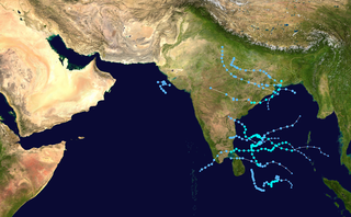
The 1996 North Indian Ocean cyclone season featured several deadly tropical cyclones, with over 2,000 people killed during the year. The India Meteorological Department (IMD) – the Regional Specialized Meteorological Center for the northern Indian Ocean as recognized by the World Meteorological Organization – issued warnings for nine tropical cyclones in the region. Storms were also tracked on an unofficial basis by the American-based Joint Typhoon Warning Center, which observed one additional storm. The basin is split between the Bay of Bengal off the east coast of India and the Arabian Sea off the west coast. During the year, the activity was affected by the monsoon season, with most storms forming in June or after October.

<span class="mw-page-title-main">1990 North Indian Ocean cyclone season</span>

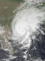
The 1990 North Indian Ocean cyclone season featured a below average total of twelve cyclonic disturbances and one of the most intense tropical cyclones in the basin on record. During the season the systems were primarily monitored by the India Meteorological Department, while other warning centres such as the United States Joint Typhoon Warning Center also monitored the area. During the season, there were at least 1,577 deaths, while the systems caused over US$693 million in damages. The most significant system was the 1990 Andhra Pradesh cyclone, which was the most intense, damaging, and the deadliest system of the season.

<span class="mw-page-title-main">1989 North Indian Ocean cyclone season</span>

The 1989 North Indian Ocean cyclone season was a below-average season in annual cycle of tropical cyclone formation. Despite this, the season had the second highest Accumulated Cyclone Energy in the basin on record behind only 2019 and 2023. The season has no official bounds but cyclones tend to form between April and December. These dates conventionally delimit the period of each year when most tropical cyclones form in the northern Indian Ocean. There are two main seas in the North Indian Ocean—the Bay of Bengal to the east of the Indian subcontinent and the Arabian Sea to the west of India. The official Regional Specialized Meteorological Centre in this basin is the India Meteorological Department (IMD), while the Joint Typhoon Warning Center (JTWC) releases unofficial advisories. An average of five tropical cyclones form in the North Indian Ocean every season with peaks in May and November. Cyclones occurring between the meridians 45°E and 100°E are included in the season by the IMD.

<span class="mw-page-title-main">1991 North Indian Ocean cyclone season</span>

The 1991 North Indian Ocean Cyclone season was an extremely deadly and destructive season causing the deaths of more than 138,000 people and over $1.5 billion in damages. It was the period in which tropical cyclones formed to the north of the equator in the Indian Ocean. During the season tropical cyclones were monitored by the India Meteorological Department (IMD) and the Joint Typhoon Warning Center. The IMD assigned all depressions that it monitored with BOB followed by a number in numerical order. The JTWC also assigned a number and either the letter A or B depending on where the depression was when the first advisory was issued.

<span class="mw-page-title-main">1993 North Indian Ocean cyclone season</span>

The 1993 North Indian Ocean cyclone season was the least active on record in the basin, with only four tropical disturbances. There are two main seas in the North Indian Ocean – the Bay of Bengal to the east of the Indian subcontinent and the Arabian Sea to the west. The India Meteorological Department (IMD) issued advisories for the systems in its official capacity as the local Regional Specialized Meteorological Center, while the Joint Typhoon Warning Center also issued advisories for two of the storms on an unofficial basis. Of the five disturbances tracked by the IMD, two intensified into cyclonic storms.

<span class="mw-page-title-main">1994 North Indian Ocean cyclone season</span>

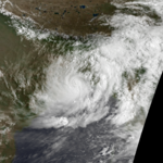
The 1994 North Indian Ocean cyclone season was a below-average year in which eight tropical cyclones affected seven countries bordering the North Indian Ocean. The India Meteorological Department tracks all tropical cyclones in the basin, north of the equator. The first system developed on March 21 in the Bay of Bengal, the first March storm in the basin since 1938. The second storm was the most powerful cyclone of the season, attaining maximum sustained winds of 215 km/h (135 mph) in the northern Bay of Bengal. Making landfall near the border of Bangladesh and Myanmar, the cyclone killed 350 people and left US$125 million in damage.

<span class="mw-page-title-main">2013 North Indian Ocean cyclone season</span>

The 2013 North Indian Ocean cyclone season was an event in the annual cycle of tropical cyclone formation, in which tropical cyclones formed in the North Indian Ocean and Arabian Sea. The season had no official bounds, but cyclones typically formed between May and December, with the peak from October to November. These dates conventionally delimit the period of each year when most tropical cyclones form in the northern Indian Ocean.

<span class="mw-page-title-main">2014 North Indian Ocean cyclone season</span>

The 2014 North Indian Ocean cyclone season was an event in the annual cycle of tropical cyclone formation. The season included two very severe cyclonic storms, both in October, and one other named cyclonic storm, classified according to the tropical cyclone intensity scale of the India Meteorological Department. Cyclone Hudhud is estimated to have caused US$3.58 billion in damage across eastern India, and more than 120 deaths.

<span class="mw-page-title-main">October 1996 India cyclone</span> North Indian Ocean cyclone in 1996

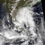
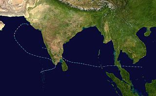
The October 1996 India cyclone had an unusual and protracted path that spanned much of the northern Indian Ocean. It originated in a weather disturbance that formed on October 14 in the southern Bay of Bengal, off India's east coast. Moving westward, it struck Andhra Pradesh on October 17 as a well-defined low-pressure area. It crossed southern India and reorganized in the Arabian Sea off the western coast of India. The system developed into a depression on October 22 and quickly intensified while moving northward. By October 24, the cyclone approached hurricane intensity as it developed an eye, reaching peak winds of at least 110 km/h (70 mph). On October 25, the storm abruptly stalled and weakened off Gujarat, and progressed southwestward as a minimal storm. It was no longer classifiable as a tropical cyclone by October 28, although its remnants persisted until November 2 when they dissipated east of Somalia.

<span class="mw-page-title-main">1995 India cyclone</span> Category 1 North Indian tropical cyclone in 1995

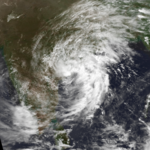
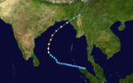
The 1995 India cyclone was a tropical cyclone that struck southeastern India which later spawned a rare snowstorm in Nepal, triggering the deadliest mountain trekking incident in the country's history in November 1995. The storm originated from the monsoon trough on November 7 in the Bay of Bengal, east of India, becoming the penultimate storm of the 1995 North Indian Ocean cyclone season. Moving northwestward, the system gradually intensified while moving toward land, eventually developing an eye in the middle of the convection. Reaching peak winds of at least 120 km/h (75 mph), the India Meteorological Department (IMD) classified the system as a very severe cyclonic storm on November 8, in line with intensity estimates from the American-based Joint Typhoon Warning Center (JTWC). On November 9, the cyclone made landfall near the border of Andhra Pradesh and Orissa. A typical for most November storms, the system continued to the north and dissipated over Nepal on November 11.

<span class="mw-page-title-main">2017 North Indian Ocean cyclone season</span>

The 2017 North Indian Ocean cyclone season was a below average yet deadly season in the annual cycle of tropical cyclone formation. This season produced only three named storms, of which one only intensified into a very severe cyclonic storm. The North Indian Ocean cyclone season has no official bounds but cyclones tend to form between April and December with the two peaks in May and November. These dates conventionally delimit the period of each year when most tropical cyclones form in the northern Indian Ocean. The season began with the formation Cyclone Maarutha on April 15 and ended with the dissipation of a deep depression on December 9.

<span class="mw-page-title-main">2018 North Indian Ocean cyclone season</span>

The 2018 North Indian Ocean cyclone season was one of the most active North Indian Ocean cyclone seasons since 1992, with the formation of fourteen depressions and seven cyclones. The North Indian Ocean cyclone season has no official bounds, but cyclones tend to form between April and December, with the two peaks in May and November. These dates conventionally delimit the period of each year when most tropical cyclones form in the northern Indian Ocean.

References

  1. 1 2 "Annual Summary of the Global Tropical Cyclone Season 2000" (PDF). World Meteorological Organization. Retrieved 2015-05-22.
  2. 1 2 3 4 5 6 7 8 9 10 11 12 13 14 15 16 17 18 19 20 21 22 23 24 "Report on cyclonic disturbances over north Indian Ocean during 1995" (PDF). India Meteorological Department. January 1996. Retrieved 2015-11-23.
  3. 1 2 3 4 5 6 7 8 9 10 11 12 13 Eric J. Trehubenko; Charles P. Guard; Gary B. Kubat; William J. Carle (1996). "1995 Annual Tropical Cyclone Report" (PDF). Hagåtña, Guam: Joint Typhoon Warning Center. pp. 214–238. Archived from the original (PDF) on 2015-09-30. Retrieved 2015-11-24.
  4. "Frequently Asked Questions on Tropical Cyclones" (PDF). India Meteorological Department. p. 15. Retrieved February 29, 2016.
  5. Ghazanfar, Shahina; Fisher, Martin (1998). Vegetation of the Arabian Peninsula. Springer. ISBN   9789401736374 . Retrieved 2015-12-04.
  6. Steve Newman (1995-05-20). "Earthweek: Diary of the planet". Toronto Star.  via Lexis Nexis (subscription required)
  7. "The Week that the Rains Came Down; Weatherwatch". The Guardian. London. 1995-05-16.  via Lexis Nexis (subscription required)
  8. "Heavy Rains Kill 17 People in Southern India". Associated Press. 1995-05-09.  via Lexis Nexis (subscription required)
  9. 1 2 "Three killed in cyclone, tidal surge on Bangladesh coast". Agence France-Presse. 1995-05-16.  via Lexis Nexis (subscription required)
  10. 1 2 3 "Floods Kill 5 People, Maroon 100,000 Others". Associated Press. 1995-05-16.  via Lexis Nexis (subscription required)
  11. 1 2 "Bangladesh – Rainstorm/Tidal Surge Information Report No. 4". ReliefWeb. United Nations Department of Humanitarian Affairs. 1995-06-05. Retrieved 2015-11-23.
  12. 1 2 "Bangladesh – Rainstorm/Tidal Surge Information Report No. 3". ReliefWeb. United Nations Department of Humanitarian Affairs. 1995-06-05. Retrieved 2015-11-23.
  13. "Cyclone death toll nears 400". Agence France-Presse. 1995-05-21.  via Lexis Nexis (subscription required)
  14. 1 2 "Tropical Cyclones" (PDF). Darwin Tropical Diagnostic Statement. Vol. 14, no. 5. Bureau of Meteorology. May 1995. p. 2. Archived from the original (PDF) on 2015-11-24. Retrieved 2015-11-23.
  15. "Tropical Cyclones" (PDF). Darwin Tropical Diagnostic Statement. Vol. 14, no. 9. Bureau of Meteorology. September 1995. p. 2. Retrieved 2015-11-24.
  16. 1 2 Richard Kattelmann; Tomomi Yamada (1997). Storms and Avalanches of November 1995, Khumbu Himal, Nepal (PDF). Proceedings International Snow Science Workshop. Retrieved 2015-11-30.
  17. 1 2 Centre for Research on the Epidemiology of Disasters. "EM-DAT: The Emergency Events Database" . Université catholique de Louvain.
  18. "Bangladesh floods". United Press International. 1995-05-10.  via Lexis Nexis (subscription required)
  19. "Avalanche, landslide survivors are returning to Nepal's capital". Bryan, Ohio. Associated Press. 1995-11-15. Retrieved 2015-12-01.
  20. "Tropical Cyclones" (PDF). Darwin Tropical Diagnostic Statement. Vol. 14, no. 11. Bureau of Meteorology. November 1995. p. 2. Archived from the original (PDF) on 2015-12-08. Retrieved 2015-12-04.
  21. "Bangladesh – Cyclone Information Report No.3". ReliefWeb. United Nations Department of Humanitarian Affairs. 1995-11-25. Retrieved 2015-12-04.
  22. Tofael Ahmed (1995-11-25). "International News". Associated Press.  via Lexis Nexis (subscription required)
  23. "100 Fishermen Killed In Weekend Cyclone". Associated Press. 1995-11-30.  via Lexis Nexis (subscription required)
  24. "The Rohingya Muslims: Ending a Cycle of Exodus?". Human Rights Watch. 8 (8). Burma Library. September 1996. Retrieved 2015-12-04.