2006 Central Pacific cyclone

Last updated
(unofficially)
2006 Central Pacific cyclone
Storm 91C 01 nov 2006 2030Z.jpg
The cyclone at peak strength on November 1

The 2006 Central Pacific cyclone, also known as Invest 91C or Storm 91C, was an unusual weather system that formed in 2006. Forming on October 30 from a mid-latitude cyclone in the north Pacific mid-latitudes, it moved over waters warmer than normal. The system acquired some features more typical of subtropical and even tropical cyclones. However, as it neared the western coastline of North America, the system fell apart, dissipating soon after landfall, on November 4. Moisture from the storm's remnants caused substantial rainfall in British Columbia and the Pacific Northwest. The exact status and nature of this weather event is unknown, with meteorologists and weather agencies having differing opinions.

Contents

Meteorological history

Map plotting the track and the intensity of the unnamed tropical cyclone (starting at left of center)

.mw-parser-output .hidden-begin{box-sizing:border-box;width:100%;padding:5px;border:none;font-size:95%}.mw-parser-output .hidden-title{font-weight:bold;line-height:1.6;text-align:left}.mw-parser-output .hidden-content{text-align:left}
Map key
Saffir-Simpson scale
.mw-parser-output .div-col{margin-top:0.3em;column-width:30em}.mw-parser-output .div-col-small{font-size:90%}.mw-parser-output .div-col-rules{column-rule:1px solid #aaa}.mw-parser-output .div-col dl,.mw-parser-output .div-col ol,.mw-parser-output .div-col ul{margin-top:0}.mw-parser-output .div-col li,.mw-parser-output .div-col dd{page-break-inside:avoid;break-inside:avoid-column}
.mw-parser-output .legend{page-break-inside:avoid;break-inside:avoid-column}.mw-parser-output .legend-color{display:inline-block;min-width:1.25em;height:1.25em;line-height:1.25;margin:1px 0;text-align:center;border:1px solid black;background-color:transparent;color:black}.mw-parser-output .legend-text{}
Tropical depression (<=38 mph, <=62 km/h)

Tropical storm (39-73 mph, 63-118 km/h)

Category 1 (74-95 mph, 119-153 km/h)

Category 2 (96-110 mph, 154-177 km/h)

Category 3 (111-129 mph, 178-208 km/h)

Category 4 (130-156 mph, 209-251 km/h)

Category 5 (>=157 mph, >=252 km/h)

Unknown
Storm type
Tropical cyclone
Subtropical cyclone
Extratropical cyclone, remnant low, tropical disturbance, or monsoon depression 91C 2006 track.png
Map plotting the track and the intensity of the unnamed tropical cyclone (starting at left of center)
Map key
  Tropical depression (≤38 mph, ≤62 km/h)
  Tropical storm (39–73 mph, 63–118 km/h)
  Category 1 (74–95 mph, 119–153 km/h)
  Category 2 (96–110 mph, 154–177 km/h)
  Category 3 (111–129 mph, 178–208 km/h)
  Category 4 (130–156 mph, 209–251 km/h)
  Category 5 (≥157 mph, ≥252 km/h)
  Unknown
Storm type
ArrowUp.svg Extratropical cyclone, remnant low, tropical disturbance, or monsoon depression

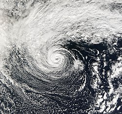
On October 28, 2006, a cut-off extratropical cyclone over the central north Pacific moved over an area of ocean with sea surface temperatures as high as 2 °C above normal, at 16–18 °C (61–64 °F), and stalled there for two days. [1] [2] [3] By October 31, the system had acquired convection, a warmer-than-normal core, [1] and an eye-like feature. [3] During this time, the storm had moved eastward, then northeastward, before turning northwestward. [1] On November 1, the system reached its peak intensity, and had estimated 1-minute sustained winds of 65 mph (100 km/h) and its most developed convection. After that, the storm slowly weakened, looped counter-clockwise, and headed east towards the west coast of North America. This system's center of circulation passed south of observation buoy 46637 on November 1. The buoy's lowest pressure reading was 989 millibars (29.2 inHg). Other buoys indicated that a rather large area of low pressure was associated with the system. Buoy 46637 was not at the system's center of circulation, so it is possible that this system had a lower minimum pressure than was actually measured. [1] On November 2, wind shear and cooler waters began to take their toll on 91C, and all convection was gone by the next day, when the storm was located roughly 520 mi (840 km) off the coast of Oregon. [1] On November 3, the storm made landfall on the Olympic Peninsula in the State of Washington, bringing tropical storm-like conditions to the Pacific Northwest, including sustained winds at 40 mph (64 km/h) and wind gusts up to 60 mph (97 km/h). [4] [3] Following its landfall, the storm rapidly weakened and dissipated on the next day. [4]

Impact, preparation, and records

In response to the weather system, the American National Weather Service issued wind watches for the Oregon Coast. [4] The National Weather Service also issued a High Wind Warning for the southern Washington coast extending as south aa Tillamook. The storm brought gale-force winds to the Pacific Northwest, including sustained winds at 40 mph (64 km/h) and wind gusts up to 60 mph (97 km/h). [4] The system also brought heavy rain to portions of Vancouver Island. [5]

If Storm 91C is considered a tropical or subtropical cyclone, it holds several records. Since it formed at 36°N, this system formed at the northernmost latitude of any cyclone in the eastern north Pacific basin. [6] The previous record-holder was Tropical Storm Wene, which formed at 32°N before crossing the dateline. [7] [8] In addition, this system's track data indicated that it crossed from the central to the east Pacific as it formed at longitude 149°W and dissipated at 135°W. [6] Only two recorded other tropical cyclones had done this previously. [8] However, since the storm was not officially classified, these records are not justified.

Nature of the system

91C at landfall in Washington on November 3 91Clandfall.jpg
91C at landfall in Washington on November 3

The classification of this system is debated, with various agencies considering it to be a tropical, subtropical, or extratropical cyclone.

Mark Guishard, a meteorologist with Bermuda Weather Service, was of the opinion that the system had completed tropical cyclogenesis and was a tropical cyclone. Meteorologist Mark Lander thought that cloud tops were similar to several Atlantic hurricanes, Hurricane Vince in particular. [1] James Franklin, a meteorologist at the National Hurricane Center, said:

The system was of frontal origin... the frontal structure was eventually lost.... The convective structure resembled a tropical, rather than subtropical cyclone, and the radius of maximum winds (based on QuikSCAT) was very close to the center, also more typical of tropical cyclones... on balance, it was more tropical than subtropical. [9]

Clark Evans of Florida State University reported that forecasting tools showed that the system's structure was consistent with that of a subtropical or marginally tropical cyclone. [1] NASA, a non-meteorological government agency, asserted that the system was a subtropical cyclone. [3]

In its review of the 2006 Atlantic hurricane season, the Canadian Hurricane Centre considered this to be an extratropical cyclone. [5]

In 2016, a study by Alicia Bentley and Nicholas Metz found that this cyclone underwent tropical transition, confirming its status as a tropical cyclone. [10]

Since this system had one-minute sustained winds of 100 km/h (65 mi/h), which are above the 60 km/h (39 mi/h) boundary between a depression and a storm, it would qualify as a named storm if it was a tropical or subtropical cyclone. However, neither of the official Regional Specialized Meteorological Centers for the eastern north Pacific, the National Hurricane Center [11] and the Central Pacific Hurricane Center, [12] include this system in their annual archives, nor is it included in the official "best track" file. [8] Hence, this system is not an official tropical or subtropical cyclone of the 2006 Pacific hurricane season.

See also

Related Research Articles

<span class="mw-page-title-main">Subtropical cyclone</span> Cyclonic storm with both tropical and extratropical characteristics

A subtropical cyclone is a weather system that has some characteristics of both tropical and extratropical cyclones.

<span class="mw-page-title-main">2002 Atlantic hurricane season</span> Hurricane season in the Atlantic Ocean

The 2002 Atlantic hurricane season was a near-average Atlantic hurricane season. It officially started on June 1, 2002, and ended on November 30, dates which conventionally limit the period of each year when most tropical cyclones develop in the Atlantic Ocean. The season produced fourteen tropical cyclones, of which twelve developed into named storms; four became hurricanes, and two attained major hurricane status. While the season's first cyclone did not develop until July 14, activity quickly picked up: eight storms developed in the month of September. It ended early however, with no tropical storms forming after October 6—a rare occurrence caused partly by El Niño conditions. The most intense hurricane of the season was Hurricane Isidore with a minimum central pressure of 934 mbar, although Hurricane Lili attained higher winds and peaked at Category 4 whereas Isidore only reached Category 3. However, Lili had a minimum central pressure of 938 mbar.

<span class="mw-page-title-main">2001 Atlantic hurricane season</span> Hurricane season in the Atlantic Ocean

The 2001 Atlantic hurricane season was a fairly active Atlantic hurricane season that produced 17 tropical cyclones, 15 named storms, nine hurricanes, and four major hurricanes. The season officially lasted from June 1, 2001, to November 30, 2001, dates which by convention limit the period of each year when tropical cyclones tend to form in the Atlantic Ocean basin. The season began with Tropical Storm Allison on June 4, and ended with Hurricane Olga, which dissipated on December 6.

<span class="mw-page-title-main">2000 Atlantic hurricane season</span> Hurricane season in the Atlantic Ocean

The 2000 Atlantic hurricane season was a fairly active hurricane season, but featured the latest first named storm in a hurricane season since 1992. The hurricane season officially began on June 1, and ended on November 30. It was slightly above average due to a La Niña weather pattern although most of the storms were weak. It was also the only season to have two of the storms affect Ireland. The first cyclone, Tropical Depression One, developed in the southern Gulf of Mexico on June 7 and dissipated after an uneventful duration. However, it would be almost two months before the first named storm, Alberto, formed near Cape Verde; Alberto also dissipated with no effects on land. Several other tropical cyclones—Tropical Depression Two, Tropical Depression Four, Chris, Ernesto, Nadine, and an unnamed subtropical storm—did not impact land. Five additional storms—Tropical Depression Nine, Florence, Isaac, Joyce, and Leslie—minimally affected land areas.

<span class="mw-page-title-main">1967 Atlantic hurricane season</span> Hurricane season in the Atlantic Ocean

The 1967 Atlantic hurricane season was an active Atlantic hurricane season overall, producing 13 nameable storms, of which 6 strengthened into hurricanes. The season officially began on June 1, 1967, and lasted until November 30, 1967. These dates, adopted by convention, historically describe the period in each year when most tropical cyclogenesis occurs in the Atlantic Ocean. The season's first system, Tropical Depression One, formed on June 10, and the last, Tropical Storm Heidi, lost tropical characteristics on November 2.

<span class="mw-page-title-main">1991 Atlantic hurricane season</span> Hurricane season in the Atlantic Ocean

The 1991 Atlantic hurricane season was the first season since 1984 in which no hurricanes developed from tropical waves, which are the source for most North Atlantic tropical cyclones. The hurricane season officially began on June 1, and ended on November 30. It was the least active in four years due to higher than usual wind shear across the Atlantic Ocean. The first storm, Ana, developed on July 2 off the southeast United States and dissipated without causing significant effects. Two other tropical storms in the season – Danny and Erika – did not significantly affect land. Danny dissipated east of the Lesser Antilles, and Erika passed through the Azores before becoming extratropical. In addition, there were four non-developing tropical depressions. The second depression of the season struck Mexico with significant accompanying rains.

<span class="mw-page-title-main">2006 Atlantic hurricane season</span> Hurricane season in the Atlantic Ocean

The 2006 Atlantic hurricane season was the least active in the basin since 1997, with nine named storms as well as an additional unnamed tropical storm identified by the National Hurricane Center. 2006 was the first season since 2001 in which no hurricanes made landfall in the United States, and was the first since 1994 in which no tropical cyclones formed during October. Following the intense activity of 2003, 2004, and 2005, forecasters predicted that the 2006 season would be only slightly less active. Instead, it turned out to be a below average season, as activity was slowed by a rapidly forming moderate El Niño event, the presence of the Saharan Air Layer over the tropical Atlantic, and the steady presence of a robust secondary high-pressure area to the Azores High centered on Bermuda. There were no tropical cyclones after October 2.

<span class="mw-page-title-main">Tropical Storm Nicholas (2003)</span> Atlantic tropical storm in 2003

Tropical Storm Nicholas was a long-lived tropical storm in October and November of the 2003 Atlantic hurricane season. Forming from a tropical wave on October 13 in the central tropical Atlantic Ocean, Nicholas developed slowly due to moderate levels of wind shear throughout its lifetime. Deep convection slowly organized, and Nicholas attained a peak intensity of 70 mph (110 km/h) on October 17. After moving west-northwestward for much of its lifetime, it turned northward and weakened due to increasing shear. The storm again turned to the west and briefly restrengthened, but after turning again to the north Nicholas transitioned to an extratropical cyclone on October 24. As an extratropical storm, Nicholas executed a large loop to the west, and after moving erratically for a week and organizing into a tropical low, it was absorbed by a non-tropical low. The low continued westward, crossed Florida, and ultimately dissipated over the Gulf Coast of the United States on November 5.

<span class="mw-page-title-main">Subtropical Storm Nicole</span> Atlantic subtropical storm in 2004

Subtropical Storm Nicole was the first subtropical storm to receive a name using the standard hurricane name list that did not become a tropical cyclone. The fifteenth tropical or subtropical cyclone and fourteenth named storm of the 2004 Atlantic hurricane season, Nicole developed on October 10 near Bermuda from a broad surface low that developed as a result of the interaction between an upper level trough and a decaying cold front. The storm turned to the northeast, passing close to Bermuda as it intensified to reach peak winds of 50 mph (80 km/h) on October 11. Deep convection developed near the center of the system as it attempted to become a fully tropical cyclone. However, it failed to do so and was absorbed by an extratropical cyclone late on October 11.

<span class="mw-page-title-main">Hurricane Ioke</span> Category 5 Pacific hurricane and typhoon in 2006

Hurricane Ioke, also referred to as Typhoon Ioke, was a record-breaking, long-lived and extremely powerful storm that traversed the Pacific for 17 days, reaching the equivalent of Category 5 status on the Saffir–Simpson hurricane scale on three different occasions. It was the most intense hurricane ever recorded in the Central Pacific, as well as the fifth-most intense Pacific hurricane on record, tied with 1973's Hurricane Ava. It also generated the most accumulated cyclone energy for a single storm, until Cyclone Freddy surpassed its record in 2023. Ioke was the ninth named storm, fifth hurricane, and third major hurricane of the active 2006 Pacific hurricane season.

<span class="mw-page-title-main">Hurricane Karen (2001)</span> Category 1 Atlantic hurricane in 2001

Hurricane Karen was a hurricane of non-tropical origin that formed in October of the 2001 Atlantic hurricane season. It developed out of the interaction between a cold front and an upper level trough on October 10 located to the south of Bermuda, and quickly strengthened as an extratropical storm. The storm passed near Bermuda on October 12, producing hurricane-force winds on the island. It then organized, becoming a subtropical cyclone on October 12 and a tropical cyclone on October 13. Karen strengthened to reach 80 mph (130 km/h) winds as a Category 1 hurricane on the Saffir-Simpson Hurricane Scale, and after weakening over cooler waters, it made landfall on Nova Scotia as a tropical storm. It quickly became extratropical.

<span class="mw-page-title-main">2005 Azores subtropical storm</span> Unnamed Atlantic subtropical storm

The 2005 Azores subtropical storm was the 19th nameable storm and only subtropical storm of the extremely active 2005 Atlantic hurricane season. It was not named by the National Hurricane Center as it was operationally classified as an extratropical low. It developed in the eastern Atlantic Ocean, an unusual region for late-season tropical cyclogenesis. Nonetheless, the system was able to generate a well-defined centre convecting around a warm core on 4 October. The system was short-lived, crossing over the Azores later on 4 October before becoming extratropical again on 5 October. No damages or fatalities were reported during that time. Its remnants were soon absorbed into a cold front. That system went on to become Hurricane Vince, which affected the Iberian Peninsula.

<span class="mw-page-title-main">Hurricane Erin (2001)</span> Category 3 Atlantic hurricane

Hurricane Erin was the longest-lived hurricane in the 2001 Atlantic hurricane season. The sixth tropical depression, fifth tropical storm, and first hurricane of the season, Erin developed from a tropical wave on September 1. After strengthening to a 60 mph (97 km/h) tropical storm as it moved to the west-northwest, wind shear weakened Erin and caused it to degenerate into a remnant low on September 5. The remnants re-organized into a tropical depression the next day, and Erin strengthened into a hurricane on September 9 while moving northwestward. This was the latest date for the first hurricane of the season since Hurricane Diana on September 10, 1984. Erin quickly intensified and reached peak winds of 120 mph (190 km/h) later on September 9. At its closest approach, Erin passed 105 miles (169 km) east-northeast of Bermuda near peak intensity, and subsequently weakened as it turned to the east. A trough turned Erin to the northeast, and after passing just east of Cape Race, Newfoundland it became extratropical on September 15. The extratropical remnant continued northeastward and was absorbed into another extratropical storm near Greenland on September 17.

<span class="mw-page-title-main">1975 Pacific Northwest hurricane</span> Category 1 Pacific hurricane in 1975

The 1975 Pacific Northwest hurricane was an unusual Pacific tropical cyclone that attained hurricane status farther north than any other Pacific hurricane. It was officially unnamed, with the cargo ship Transcolorado providing vital meteorological data in assessing the storm. The twelfth tropical cyclone of the 1975 Pacific hurricane season, it developed from a cold-core upper-level low merging with the remnants of a tropical cyclone on August 31, well to the northeast of Hawaii. Convection increased as the circulation became better defined, and by early on September 2, it became a tropical storm. Turning to the northeast through an area of warm water temperatures, the storm quickly strengthened, and, after developing an eye, it attained hurricane status late on September 3, while located about 1,200 miles (1,950 km) south of Alaska. After maintaining peak winds for about 18 hours, the storm rapidly weakened, as it interacted with an approaching cold front. Early on September 5, it lost its identity near the coast of Alaska.

<span class="mw-page-title-main">Tropical Storm Chantal (2007)</span> Atlantic tropical storm in 2007

Tropical Storm Chantal was a short-lived tropical storm that affected Bermuda in its formative stages and caused flooding and gusty winds in Newfoundland while extratropical. The third named storm of the 2007 Atlantic hurricane season, Chantal developed on July 31 from non-tropical origins between Bermuda and Cape Cod, and with favorable conditions, the storm rapidly attained peak winds of 50 mph (80 km/h). The storm accelerated northeastward over an area of progressively colder water temperatures, and after a decrease in convection the National Hurricane Center ceased issuing advisories as Chantal began undergoing extratropical transition early on August 1. Shortly thereafter, the extratropical remnant crossed over southeastern Newfoundland before tracking into the open waters of the north Atlantic Ocean. Prior to forming, the storm dropped moderate rainfall on Bermuda. Subsequent to becoming extratropical, the remnants of Chantal produced gusty winds and heavy precipitation across the Avalon Peninsula of Newfoundland, causing flooding and wind damage; insured damage totaled $25 million.

<span class="mw-page-title-main">2006 Pacific hurricane season</span> Hurricane season in the Pacific Ocean

The 2006 Pacific hurricane season was the first above-average season since 1997 which produced twenty-five tropical cyclones, with nineteen named storms, though most were rather weak and short-lived. There were eleven hurricanes, of which six became major hurricanes. Following the inactivity of the previous seasons, forecasters predicted that season would be only slightly above active. It was also the first time since 2003 in which one cyclone of at least tropical storm intensity made landfall. The season officially began on May 15 in the East Pacific Ocean, and on June 1 in the Central Pacific; they ended on November 30. These dates conventionally delimit the period of each year when most tropical cyclones form in the Pacific basin. However, the formation of tropical cyclones is possible at any time of the year.

<span class="mw-page-title-main">Hurricane Grace (1991)</span> Category 2 Atlantic hurricane in 1991

Hurricane Grace was a short-lived Category 2 hurricane that contributed to the formation of the powerful 1991 Perfect Storm. Forming on October 26, Grace initially had subtropical origins, meaning it was partially tropical and partially extratropical in nature. It became a tropical cyclone on October 27, and ultimately peaked with winds of 105 mph (165 km/h). The storm had minor effects on the island of Bermuda as it passed to the south. A developing extratropical storm to the north turned Grace eastward; the hurricane was eventually absorbed into the large circulation of the larger low-pressure system. Fed by the contrast between cold air to the northwest and warm air from the remnants of Grace, this storm became a large and powerful Nor'easter that caused extremely high waves and resulted in severe coastal damage along the East Coast of the United States.

<span class="mw-page-title-main">Tropical Storm Omeka</span> Pacific tropical storm in 2010

Tropical Storm Omeka was the latest forming Eastern Pacific named storm since reliable records began in the 1960s. The storm was part of the 2010 Pacific typhoon and hurricane season. On December 18, 2010, the Central Pacific Hurricane Center (CPHC) began monitoring a subtropical cyclone near the International Dateline for possible tropical cyclogenesis. Over the following two days, the system tracked southwestward, entering the Western Pacific basin. It then began to transition into a tropical cyclone. Shortly before crossing the dateline on December 20, the CPHC assessed the system to have become a tropical storm. The storm was assigned the name Omeka several hours later as it moved into the CPHC's area of responsibility, which is from 140°W to the International Dateline. Upon doing so, Omeka attained its peak intensity with winds of 60 mph (100 km/h). Later on December 20, wind shear in the region increased, causing the system to weaken. By December 21, the center of Omeka was devoid of convection and dissipated on the next day. Omeka brushed Lisianski Island but caused no damage.

<span class="mw-page-title-main">Glossary of tropical cyclone terms</span>

The following is a glossary of tropical cyclone terms.

<span class="mw-page-title-main">Hurricane Pablo</span> Category 1 Atlantic hurricane in 2019

Hurricane Pablo was a late-season Category 1 hurricane that became the farthest east-forming hurricane in the North Atlantic tropical cyclone basin on record, beating the previous record set by Hurricane Vince in 2005. The seventeenth tropical/subtropical cyclone, sixteenth named storm and sixth hurricane of the 2019 Atlantic hurricane season, Pablo originated from a baroclinic cyclone a few hundred miles west of the Azores Islands. The precursor cyclone formed on October 22, traveling eastward towards the island chain. The system initially had multiple centers of circulation, but they consolidated into one small low-pressure system embedded within the larger extratropical storm. On October 25, the embedded cyclone developed into a subtropical cyclone, receiving the name Pablo. The cyclone continued eastwards, transitioning into a fully-tropical storm later that day. Pablo quickly intensified between October 26 and 27, forming an eye and spiral rainbands. At 12:00 Coordinated Universal Time (UTC) on October 27, Pablo intensified into a Category 1 hurricane. The storm continued to strengthen, reaching its peak intensity of 80 mph (130 km/h) and a minimum central pressure of 977 mbar (28.9 inHg) at 18:00 UTC on the same day. The storm quickly weakened the next day, becoming extratropical again, and dissipated on October 29.

References

  1. 1 2 3 4 5 6 7 Gary Padgett. "Possible Tropical Cyclone". Archived from the original on 2008-08-02. Retrieved 2008-01-01.
  2. Dr. Jeff Masters (November 2, 2006). "Thingamabobbercane forms off coast of Oregon". Weather Underground. Retrieved September 30, 2017.
  3. 1 2 3 4 "Subtropical Storm off the Coast of Oregon". NASA. November 2, 2006. Retrieved September 30, 2017.
  4. 1 2 3 4 "First Storm Set to Wow Oregon Coast". Beach Connection. Retrieved 2008-01-01.
  5. 1 2 "2006 Atlantic Hurricane Season Review". Canadian Hurricane Center. 2007-05-22. Archived from the original on 2007-07-26. Retrieved 2008-01-01.
  6. 1 2 Gary Padgett; Karl Hoarau. "Global Tropical Cyclone Tracks — November 2006" . Retrieved 2008-01-02.
  7. "Tropical Storm (TS) 16W (Wene*)". 2000 Annual Tropical Cyclone Report. Joint Typhoon Warning Center. Archived from the original on 2011-06-07. Retrieved 2008-01-02.
  8. 1 2 3 National Hurricane Center; Hurricane Research Division; Central Pacific Hurricane Center (April 4, 2023). "The Northeast and North Central Pacific hurricane database 1949–2022". United States National Oceanic and Atmospheric Administration's National Weather Service. A guide on how to read the database is available here. PD-icon.svg This article incorporates text from this source, which is in the public domain.
  9. "Thingamabobbercane revisited". Jeff Masters' Blog. Weather Underground. November 8, 2006. Retrieved September 30, 2017.
  10. Bently, Alicia (February 1, 2016). "Tropical Transition of an Unnamed, High-Latitude, Tropical Cyclone over the Eastern North Pacific". Monthly Weather Review. 144 (2): 713–736. Bibcode:2016MWRv..144..713B. doi: 10.1175/MWR-D-15-0213.1 . S2CID   123316839 . Retrieved 11 October 2022.
  11. "2006 Eastern Pacific Hurricane Season". National Hurricane Center. Archived from the original on 12 February 2008. Retrieved 2008-01-01.
  12. Andy Nash; Tim Craig; Sam Houston; Roy Matsuda; Jeff Powell; Ray Tanabe; Jim Weyman (July 2007). "2006 Tropical Cyclones Central North Pacific". Central Pacific Hurricane Center. Archived from the original on 3 January 2008. Retrieved 2008-01-01.