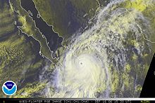
Hurricane Keith was a tropical cyclone in October 2000 that caused extensive damage in Central America, especially in Mexico and Belize. It was the fifteenth tropical cyclone, eleventh named storm, and seventh hurricane of the 2000 Atlantic hurricane season. Keith developed as a tropical depression from a tropical wave in the western Caribbean Sea on September 28. The depression gradually strengthened, and became Tropical Storm Keith on the following day. As the storm tracked westward, it continued to intensify and was upgraded to a hurricane on September 30. Shortly thereafter, Keith began to rapidly deepen, and peaked as a Category 4 hurricane less than 24 hours later. Keith then began to meander erratically offshore of Belize, which significantly weakened the storm due to land interaction. By late on October 2, Keith made landfall in Ambergris Caye and Caye Caulker, Belize as a minimal hurricane. It quickly weakened to a tropical storm, before another landfall occurred near Belize City early on the following day. While moving inland over the Yucatán Peninsula, Keith weakened further, and was downgraded to a tropical depression before emerging into the Gulf of Mexico on October 4. Once in the Gulf of Mexico, Keith began to re-strengthen and was upgraded to a tropical storm later that day, and a hurricane on the following day. By late on October 5, Keith made its third and final landfall near Tampico, Tamaulipas, Mexico as a moderately strong Category 1 hurricane. The storm quickly weakened inland and dissipated as a tropical cyclone by 24 hours after landfall.

The 2007 Atlantic hurricane season was the first season since 2003 to feature tropical activity both before and after the official bounds of the season. There were an above-average number of named storms during the season – 15, however many storms were weak and short-lived. Despite the predominance of weak systems, this was the first season on record to feature more than one Category 5 landfalling hurricane. This would not happen again until 2017. It produced 17 tropical cyclones, 15 tropical storms, six hurricanes, and two major hurricanes. It officially started on June 1 and ended on November 30, dates which conventionally delimit the period during which most tropical cyclones form in the Atlantic Ocean, although as shown by Subtropical Storm Andrea and Tropical Storm Olga in early May and early December, respectively, the formation of tropical cyclones is possible at any time of the year. The first system, Subtropical Storm Andrea, developed on May 9, while the last storm, Tropical Storm Olga, dissipated on December 13. The most intense hurricane, Dean, was, at the time, the third most intense landfalling Atlantic storm on record. It was the second on record in which an Atlantic hurricane, Felix, and an eastern Pacific hurricane, Henriette, made landfall on the same day. September had a then record-tying eight storms, until it was surpassed in 2020. However, the strengths and durations of most of the storms were low.

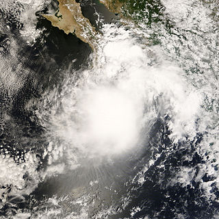
Hurricane Ismael was a weak, but deadly Pacific hurricane that killed over one hundred people in northern Mexico in September of the 1995 Pacific hurricane season. It developed from a persistent area of deep convection on September 12, and steadily strengthened as it moved to the north-northwest. Ismael attained hurricane status on September 14 while located 210 miles (340 km) off the coast of Mexico. It continued to the north, and after passing a short distance east of Baja California Sur it made landfall on Topolobampo in the state of Sinaloa with winds of 80 mph (130 km/h). Ismael rapidly weakened over land, and dissipated on September 16 over northwestern Mexico. The remnants entered the United States and extended eastward into the Mid-Atlantic States.

Tropical Storm Fay was the sixth named storm of the 2002 Atlantic hurricane season; it was a moderate tropical storm which caused flooding in parts of Texas and Northern Mexico. It formed from a trough of low pressure that moved south into the Gulf of Mexico, and became stationary. A low pressure center developed along this trough, and on September 5, a Hurricane Hunter aircraft reported that the system had gained sufficient organization to be classified a tropical depression, 95 miles (153 km) southeast of Galveston. The depression drifted south-southwest while strengthening, reaching its peak strength of 60 miles per hour (97 km/h) on the morning of September 6. The system then made an abrupt turn to the west-northwest, and remained steady in strength and course until landfall the next day, near Matagorda. The system weakened rapidly after landfall degenerating into a remnant low on September 8, but the storm's circulation survived for another three days.
Hurricane John was a Category 4 hurricane that caused heavy flooding and extensive damage across most of the Pacific coast of Mexico in late August through early September 2006. John was the eleventh named storm, seventh hurricane, and fifth major hurricane of the 2006 Pacific hurricane season. Hurricane John developed on August 28 from a tropical wave to the south of Mexico. Favorable conditions allowed the storm to intensify quickly, and it attained peak winds of 130 mph (210 km/h) on August 30. Eyewall replacement cycles and land interaction with western Mexico weakened the hurricane, and John made landfall on southeastern Baja California Sur with winds of 110 mph (180 km/h) on September 1. It slowly weakened as it moved northwestward through the Baja California peninsula, and dissipated on September 4. Moisture from the remnants of the storm entered the southwest United States.

Hurricane Paul was a Category 2 Pacific hurricane that struck Mexico as a tropical depression in October 2006. The seventeenth named storm and tenth hurricane of the annual hurricane season, Paul developed from an area of disturbed weather on October 21. The cyclone slowly intensified as it moved into an area of warm waters and progressively decreasing wind shear. Paul attained hurricane status on October 23, and later that day the storm reached its peak intensity with maximum sustained winds of 105 mph (169 km/h), a strong Category 2 hurricane on the Saffir-Simpson scale. A strong trough turned the hurricane to the north and northeast into an area of strong vertical shear, and Paul weakened to a tropical storm on October 24. It accelerated northeastward, and after passing a short distance south of Baja California Sur the low level circulation became decoupled from the rest of the convection. Paul weakened to a tropical depression on October 25 a short distance off the coast of Mexico, and after briefly turning away from the coast it made landfall on northwestern Sinaloa on October 26. The depression dissipated shortly thereafter.

Hurricane Isis was the only hurricane to make landfall during the 1998 Pacific hurricane season. The ninth tropical storm and sixth hurricane of the season, Isis developed on September 1 from an interaction between a tropical wave and a large surface circulation to the southwest of Mexico. It moved northward, striking the extreme southeastern portion of the Baja California peninsula before attaining hurricane status in the Gulf of California. Isis made landfall at Topolobampo in the Mexican state of Sinaloa on September 3, and quickly lost its low-level circulation. The remnants persisted for several days before dissipating over the U.S. state of Idaho on September 8.
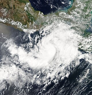
Tropical Storm Barbara was the first tropical cyclone to make landfall during the 2007 Pacific hurricane season. The second storm of the season, Barbara developed from a small low-pressure area on May 29 about 235 miles (380 km) southeast of Acapulco, Mexico. The system drifted southward before turning to a steadily eastward motion, and quickly intensified into a tropical storm. Increased wind shear weakened Barbara, though it re-organized to attain peak winds of 50 mph (80 km/h) before moving ashore just west of the border of Mexico and Guatemala. It rapidly weakened over land, and on June 2 the National Hurricane Center discontinued advisories on the storm. Despite expectations that the storm would attain hurricane status, Barbara moved ashore as a small, weak tropical storm. It produced locally heavy rainfall and gusty winds, and in most locations damage was minor. However, in southern Mexico, the rainfall destroyed large areas of cropland, with crop damage totaling 200 million pesos. In El Salvador, four people were killed by storm-induced floods.

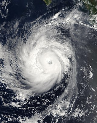
Hurricane Felix was an extremely powerful tropical cyclone which was the southernmost-landfalling Category 5 storm on record, surpassing Hurricane Edith of 1971. It was the sixth named storm, second hurricane, and second Category 5 hurricane of the 2007 Atlantic hurricane season. Felix formed from a tropical wave on August 31, passing through the southern Windward Islands on September 1 before strengthening to attain hurricane status. On the next day, Felix rapidly strengthened into a major hurricane, and early on September 3 it was upgraded to Category 5 status; at 2100 UTC on the same day, the hurricane was downgraded to Category 4 status, but strengthened into a Category 5 hurricane for the second and final time by the morning of September 4.

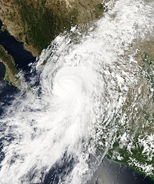
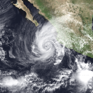
Hurricane Henriette was a minimal Category 1 hurricane that affected portions of Mexico in late August and early September 2007. The storm, which caused nine fatalities, formed from an area of disturbed weather on August 30, 2007, and became a tropical storm the next day. The cyclone moved parallel to the Mexican Pacific coast, but its proximity to the shore resulted in heavy rainfall over land. The most affected city was Acapulco, Guerrero, where six people were killed by landslides, and where over 100 families had to be evacuated after the La Sabana River flooded. Henriette then turned north and headed towards the Baja California peninsula, and became a Category 1 hurricane on the Saffir-Simpson Hurricane Scale. Henriette made its first landfall east of Cabo San Lucas at peak intensity, causing the death of one woman due to high surf.
Tropical Storm Julio was a tropical storm that made landfall on the southern tip of Baja California Sur in August 2008. The eleventh named storm of the 2008 Pacific hurricane season, it developed from a tropical wave on August 23 off the coast of Mexico. It moved parallel to the coast, reaching peak winds of 50 mph (85 km/h) before moving ashore and weakening. On August 26 it dissipated in the Gulf of California. Julio was the third tropical cyclone to make landfall in the Eastern Pacific tropical cyclone basin during the season, after Tropical Storm Alma, which struck Nicaragua in May, and Tropical Depression Five-E, which moved ashore along southwestern Mexico in July. The storm brought locally heavy rainfall to southern Baja California, killing one person and leaving several towns isolated. Moisture from Julio reached Arizona, producing thunderstorms, including one which damaged ten small planes in Chandler.

The 2006 Pacific hurricane season was the first above-average season since 1997 which produced twenty-five tropical cyclones, with nineteen named storms, though most were rather weak and short-lived. There were eleven hurricanes, of which six became major hurricanes. Following the inactivity of the previous seasons, forecasters predicted that season would be only slightly above active. It was also the first time since 2003 in which one cyclone of at least tropical storm intensity made landfall. The season officially began on May 15 in the East Pacific Ocean, and on June 1 in the Central Pacific; they ended on November 30. These dates conventionally delimit the period of each year when most tropical cyclones form in the Pacific basin. However, the formation of tropical cyclones is possible at any time of the year.
Hurricane Rosa was the only Pacific hurricane to make landfall during the above-average 1994 Pacific hurricane season. It killed at least 4 people in Mexico. Moisture from the hurricane was a factor in widespread flooding in the U.S. state of Texas that killed 22 people and caused hundreds of millions of dollars in damage in October 1994. The pre-Rosa tropical depression formed on October 8 before degenerating the next day. It reformed on October 10 and steadily strengthened as it approached Mexico. Ultimately peaking as a Category 2 hurricane on the Saffir-Simpson Hurricane Scale right before landfall, Rosa was the final hurricane, nineteenth tropical storm, and second-last tropical cyclone of the 1994 Pacific hurricane season.
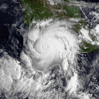
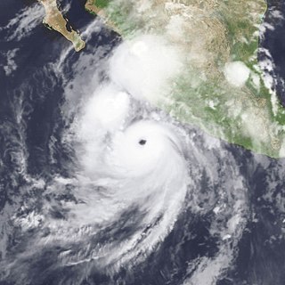
Hurricane Norbert is tied with Hurricane Jimena as the strongest tropical cyclone to strike the west coast of Baja California Sur in recorded history. The fifteenth named storm, seventh hurricane, and second major hurricane of the 2008 hurricane season, Norbert originated as a tropical depression from a tropical wave south of Acapulco on October 3. Strong wind shear initially prevented much development, but the cyclone encountered a more favorable environment as it moved westward. On October 5, the National Hurricane Center (NHC) upgraded the depression to Tropical Storm Norbert, and the system intensified further to attain hurricane intensity by October 6. After undergoing a period of rapid deepening, Norbert reached its peak intensity as a Category 4 on the Saffir–Simpson hurricane wind scale, with maximum sustained winds of 135 mph (217 km/h) and a minimum barometric pressure of 945 mbar. As the cyclone rounded the western periphery of a subtropical ridge over Mexico, it began an eyewall replacement cycle which led to steady weakening. Completing this cycle and briefly reintensifying into a major hurricane, a Category 3 or higher on the Saffir–Simpson hurricane wind scale, Norbert moved ashore Baja California Sur as a Category 2 hurricane late on October 11. After a second landfall at a weaker intensity the following day, the system quickly weakened over land and dissipated that afternoon.

Tropical Depression One-E was the earliest tropical cyclone in the calendar year to impact the Mexican state of Sinaloa ever recorded. The first system of the 2009 Pacific hurricane season, One-E formed out of an area of disturbed weather on June 18, 2009, and initially tracked slowly northwards. Throughout the day, convection developed around the center of circulation and the system was anticipated to become a tropical storm. Late on June 18, the National Hurricane Center noted that the system was on the verge of becoming a tropical storm; it would have been named Andres had this occurred. However, the following day, strong wind shear caused the depression to rapidly degenerate into a trough of low pressure before dissipating off the coast of Sinaloa.
Hurricane Lidia was the strongest tropical cyclone of the 1993 Pacific hurricane season. Forming from a tropical wave on September 8, Lidia steadily organized and became a hurricane on September 10. The hurricane continued to strengthen while developing a well-defined eye, and peaked as a Category 4 hurricane on September 11. However, it weakened considerably before making landfall in Sinaloa as a Category 2 storm. Lidia dissipated near Austin on September 14 and was later absorbed by a cold front. Across Mexico, the hurricane killed seven people; over 100,000 people were forced to evacuate their homes. A total of 160 homes were destroyed and 10,000 people were left homeless because of the storm. In the United States, five people suffered injuries and storm damage totaled $8 million.

Hurricane Manuel was a catastrophic tropical cyclone that brought widespread flooding across much of Mexico in September 2013, in conjunction with Hurricane Ingrid. The fifteenth named storm and seventh hurricane of the annual hurricane season, Manuel originated from a strong area of low pressure south of Acapulco on September 13. Within favorable conditions aloft, the storm intensified into a tropical storm as it tracked northward. The following day, Manuel curved westward and strengthened to a point just shy of hurricane intensity before making its first landfall at that intensity on September 15. Due to interaction with land, the tropical storm quickly weakened, and its center dissipated over western Mexico on September 16. However, the storm's remnants continued to track northwestward into the Gulf of California, where they reorganized into a tropical cyclone the next day. Manuel regained tropical storm status on September 18 as it began to curve northeastward. Shortly thereafter, Manuel attained Category 1 hurricane intensity, before making its final landfall just west of Culiacán at peak intensity. Over land, Manuel quickly weakened due to interaction with Mexico's high terrain, and the storm dissipated early on September 20.

Hurricane Olaf was a Category 2 Pacific hurricane that struck the Baja California Peninsula in September 2021. The fifteenth named storm and sixth hurricane of the 2021 Pacific hurricane season, the cyclone formed from an area of low pressure that developed off the southwestern coast of Mexico on September 5, 2021. The disturbance developed within a favorable environment, acquiring more convection and a closed surface circulation. The disturbance developed into Tropical Depression Fifteen-E by 18:00 UTC on September 7. The depression strengthened into a tropical storm and was named Olaf at 12:00 UTC the next day. Olaf quickly strengthened as it moved to the north-northwest, and was upgraded to a hurricane 24 hours after being named. Hurricane Olaf continued to intensify and reached peak intensity while its center was just offshore the southwestern coast of Baja California Sur, with maximum sustained winds of 105 mph (169 km/h) and a minimum barometric pressure of 975 mbar (28.8 inHg). Just after reaching peak intensity, the hurricane made landfall near San José del Cabo. Interaction with the mountainous terrain of the Baja California Peninsula caused Olaf to quickly weaken. It was downgraded to a tropical storm at 12:00 UTC on September 10. The system became devoid of convection later that day and degenerated to a remnant low by 06:00 UTC on September 11.

Hurricane Orlene was a powerful tropical cyclone that caused minor damage to the Pacific coast of Mexico in October 2022. The cyclone was the sixteenth named storm, ninth hurricane, and third major hurricane of the 2022 Pacific hurricane season. Orlene originated from a low-pressure area off the coast of Mexico. Moving towards the north, Orlene gradually strengthened, becoming a hurricane on October 1 and reaching its peak intensity the following day with winds of 130 mph (215 km/h). Orlene made landfall just north of the Nayarit and Sinaloa border, with winds of 85 mph (140 km/h). Soon afterward, Orlene rapidly weakened and became a tropical depression, eventually dissipating over the Sierra Madre Occidental late on October 4.